
Pichl near Wels
|
market community Pichl near Wels
|
||
|---|---|---|
| coat of arms | Austria map | |
 |
|
|
| Basic data | ||
| Country: | Austria | |
| State : | Upper Austria | |
| Political District : | Catfish Land | |
| License plate : | WL | |
| Surface: | 26.42 km² | |
| Coordinates : | 48 ° 11 ' N , 13 ° 54' E | |
| Height : | 332 m above sea level A. | |
| Residents : | 2,911 (January 1, 2020) | |
| Population density : | 110 inhabitants per km² | |
| Postal code : | 4632 | |
| Area code : | 07247 | |
| Community code : | 4 18 16 | |
| NUTS region | AT312 | |
| UN / LOCODE | AT PWE | |
| Address of the municipal administration: |
Community of Pichl near Wels Community square 7 4632 Pichl near Wels |
|
| Website: | ||
| politics | ||
| Mayoress : | Gabriele Maria Aicher ( ÖVP ) | |
|
Municipal Council : (2015) (25 members) |
||
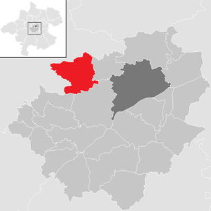
| Location of Pichl bei Wels in the Wels-Land district | ||
  |
||
 The place Pichl |
||
| Source: Municipal data from Statistics Austria | ||

Pichl bei Wels is a market town in Upper Austria in the Wels-Land district in the Hausruckviertel with 2911 inhabitants (as of January 1, 2020). The responsible judicial district is Wels.
geography
Pichl bei Wels lies at an altitude of 332 m above sea level. A. in the Hausruckviertel. The extension is 7.5 km from north to south and 6.6 km from west to east. The total area is 26.3 km². 14.8% of the area is forested, 74.6% of the area is used for agriculture.
Community structure
Cadastral communities are Oberthanbach , Ödt , Pichl bei Wels, Sulzbach , Unterthanbach , Weilbach .
The municipality includes the following localities (population in brackets as of January 1, 2020):
- Oh (12)
- Aichet (6)
- Aichmuehl (18)
- Am Irrach (13)
- Anxiety Loan (7)
- Au (12) (also Krenglbach )
- Excavation (8)
- Brandstatt (4)
- Breitwies (35)
- Etzelsdorf (246)
- Fadleit (63)
- Falzberg (8)
- Franzing (33)
- Clearance (39)
- Geisensheim (114)
- Hague (10)
- High float (9)
- Wooden houses (47)
- Inn (27)
- Jagersberg (4)
- Kaiserleiten (46)
- Kerschberg (9)
- Krottendorf (17)
- Lechlödt (3)
- Malling (5)
- Mitterleiten (16)
- Moosleiten (11)
- Müllerberg (21) (also Bad Schallerbach and Wallern )
- Nisting (26)
- Oberirrach (10)
- Oberndorf (13)
- Oberthambach (31)
- Wasteland (43)
- Pfaffendorf (97)
- Pichl near Wels (717) (main town)
- Pröstlsberg (10)
- Puchet (10) (also Schlüßlberg )
- Pühret (1)
- Schalbach (420)
- Schmiedsberg (14)
- Schnappling (15)
- Cutting Ring (142)
- Schustersberg (3)
- Silbersberg (15)
- Stadl (25)
- Steinpichl (16)
- Sulzbach (120)
- Trappelsberg (12)
- Unterirrach (224)
- Unterthambach (25)
- Uttendorf (7)
- Waldgattern (21)
- Weilbach (40)
- Vineyard (6)
- Angular field (5)
Counting areas are the Pichl central area and the Pichl area .
Neighboring communities
.svg)
history
Originally located in the eastern part of the Duchy of Bavaria , the place belonged to the Duchy of Austria since the 12th century . Since 1490 it has been assigned to the Principality of Austria ob der Enns .
During the Napoleonic Wars , the place was occupied several times.
After the annexation of Austria to the German Reich on March 13, 1938, the place belonged to the Gau Oberdonau .
The market survey took place on March 19, 2012.
Population development
In 1991, according to the census, the municipality had 2,503 inhabitants, in 2001 it had 2,719 inhabitants.
politics
The municipal council (2015) consists of 25 members and is divided between the ÖVP (12), FPÖ (6), SPÖ (4), GRÜNE (2) and DW (1).
- mayor
- until 2020 Johann Doppelbauer (ÖVP)
- since 2020 Gabriele Aicher (ÖVP)
coat of arms
Official description of the municipal coat of arms:
- In silver over a green hill, two red, floating crosses side by side , the inner side arms of which have been removed .
The community colors are green-white-red .
The hill explains the place name (obd. Bühel, Pichl , ' hill '); the rare herald figure - crosses with their backs turned against each other with half crossbars - is taken from the coat of arms of the Schmidtauers, who were lords of Etzelsdorf in the 14th century .
Culture and sights
- Filialkirche Unterirrach in Unterirrach : The church has a two-bay, ribbed, late Gothic choir with a 3/8 end and a flat ceiling with a stucco frame decoration in the nave. The ridge turret wears an onion helmet.
- Filialkirche Sulzbach in Sulzbach : The late Gothic church was once an important pilgrimage church. A healing well, which was used against eye diseases, and St. Valentin, who was considered a protector and helper against Fraisen and epilepsy, were the goal of up to 40 pilgrimages during one year.
- Parish church Pichl near Wels : The originally Gothic church was rebuilt by Johann Michael Prunner in 1734–1736 and renovated by Johann Matthias Krinner after a fire in 1750. The main painting on the high altar shows the glorification of Bishop Martin von Tours from 1761 by Bartolomeo Altomonte .
- Etzelsdorf Castle : The first records of the castle go back to the 12th century. The current building dates from the 17th century. The farm buildings are laid out separately from the main building. In the summer of 1944, the National Socialist People's Welfare Association built a “ foreign national children's home” in Etzelsdorf Castle . Until the end of 1946, children of forced laborers were housed here. Thirteen of these children died in the fall of 1944 due to poor care and nutrition.

Filial church St. Jakob

Filial church of St. Valentin in Sulzbach

Etzelsdorf Castle


Web links
- Community website
- 41816 - Pichl near Wels. Community data, Statistics Austria .
- Further information about the municipality of Pichl bei Wels can be found on the geographic information system of the federal state of Upper Austria .
- Map in the Digital Upper Austrian Room Information System ( DORIS )
Individual evidence
- ↑ Statistics Austria: Population on January 1st, 2020 by locality (area status on January 1st, 2020) , ( CSV )
- ↑ Changes to the community from 1945 (associations, partitions, name and status changes). Statistics Austria, p. 174 , accessed on February 16, 2019 .
- ↑ Marktgemeinde Pichl / Politik , accessed on July 3, 2016
- ↑ The children of Etzelsdorf Castle ( page no longer available , search in web archives ) Info: The link was automatically marked as defective. Please check the link according to the instructions and then remove this notice. , dioezese-linz.at

Aichkirchen | Bachmanning | Bad Wimsbach-Neydharting | Buchkirchen | Eberstalzell | Edt at Lambach | Fischlham | Gunskirchen | Holzhausen | Krenglbach | Lambach | Marchtrenk | Neukirchen bei Lambach | Offenhausen | Pennewang | Pichl near Wels | Sattledt | Schleissheim | Sipbachzell | Stadl-Paura | Steinerkirchen an der Traun | Stone house | Thalheim near Wels | Weißkirchen an der Traun
Cadastral communities: Oberthanbach | Wasteland | Pichl near Wels | Sulzbach | Unterthanbach | Weilbach
Locations: Oh | Aichet | Aichmühl | Am Irrach | Anxiety Loan | Au | Auhub | Brandstatt | Breitwies | Etzelsdorf | Fadleit | Falzberg | Franzing | Freedom | Geisensheim | Hague | Hochwimm | Wooden houses | Inn | Jägersberg | Kaiserleiten | Kerschberg | Krottendorf | Lechlödt | Malling | Mitterleiten | Moosleiten | Müllerberg | Nisting | Oberirrach | Oberndorf | Oberthambach | Wasteland | Pfaffendorf | Pichl near Wels | Pröstlsberg | Puchet | Pühret | Schalbach | Schmiedsberg | Schnappling | Cutting ring | Schustersberg | Silbersberg | Stadl | Steinpichl | Sulzbach | Trappelsberg | Unterirrach | Unterthambach | Uttendorf | Waldgattern | Weilbach | Vineyard | Angular field
Villages:
Etzelsdorf •
Geisensheim •
Pfaffendorf •
Pichl bei Wels •
Schalbach •
Schnittering •
Unterirrach
Weiler:
Aichmühl •
Angsterlehen •
Franzing •
Haag •
Kerschberg •
Krottendorf •
Malling •
Oberndorf •
Puchet •
Stadl •
Steinpichl •
Unterthambach •
Uttendorf •
Waldgattern •
Winkelfeld
Rotten
Ach •
Aichet •
Auhub •
Breitwies •
Fadleiten •
Falzberg •
Freiung •
Hochwimm •
Inn •
Kaiserleiten •
Lechlödt •
Mitterleiten •
Moosleiten •
Müllerberg •
Nisting •
Oberirrach •
Oberthambach •
Ödt •
Pröstlsberg •
Schmiedsberg •
Schnappling •
Schustersberg •
Silbersberg •
Trappelsberg •
Weilbach •
Vineyard
Scattered Houses:
Am Irrach •
Wooden Houses •
Sulzbach |
Other locations:
Au •
Brandstatt •
Jägersberg •
Pühret
Counting district: Pichl central area | Pichl area