St. Peter (Linz)
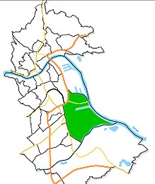
Until the incorporation in 1915, St. Peter was a suburb in the east of the city of Linz and until the end of 2013 it was both a district and a statistical district . This was inhabited by 254 registered residents in 2012. Most of the area has belonged to the newly created Industriegebiet-Hafen district since 2014 , with a small part going to the Franckviertel . The cadastral parish of St. Peter still exists on most of the area .
history
An ecclesiastical community (Ecclesia) is mentioned as early as 1111 and, in the middle of the 12th century, a church or chapel consecrated to St. Peter with the right to be buried. This was established by the Archbishopric of St. Peter in Salzburg and the cathedral chapter of the archdiocese.
The village of St. Peter had 298 inhabitants in 46 houses in 1827 and the neighboring Zitzlau, with which St. Peter formed the parish of the same name, 365 inhabitants in 40 houses. St. Peter became an independent parish in 1863 and an independent parish in 1851. The village of St. Peter was incorporated into the urban area of Linz in 1915. Originally dominated by farmers, a few factories were established in St. Peter in the 19th century, such as the Josef Estermann soap factory and a factory in the Kleinmünchner spinning mill , which employed a few hundred workers. From 1932 to 1937 numerous single-family houses were built as suburban settlements to alleviate the housing shortage at the time. A few of these houses on Strattnerstrasse and Gaisbergerstrasse have been preserved to this day. Since St. Peter was a popular excursion destination for the people of Linz, there were also several inns here.
As a result of the proximity to the Danube , the entire East was built sparsely from Linz, was determined by the regulation of the Danube , a new zoning plan drafted in 1934, in which the region was intended for industrial development. In 1938 the district of St. Peter-Zizlau by the Nazis for that was originally in the room Enns - Asten planned, Hermann Goering Works - later VÖEST , today voestalpine - wiped out. 4,500 residents were relocated to other parts of the city, where replacement accommodation was made available. Around 500 homeowners were given building sites with new housing developments in Keferfeld , residents of rental apartments were largely relocated to today's Wiener Straße in the Kleinmünchen district . Some of these accommodations had amenities such as bathrooms with running water.
The parish was transferred to Linz, Spallerhof and still exists today as the parish Linz - St. Peter .
As part of the reorganization of the districts on January 1, 2014 (decision of the city senate of September 2013), St. Peter was largely absorbed in the newly created industrial area-port district. A small part went to the Franckviertel .
The cadastral community of St. Peter (KG 45208) still exists on most of the area of the former district ; it borders on Ufer (KG 45209) to the south, Kleinmünchen (KG 45202) and Waldegg (KG 45210) to the west, and Lustenau to the north (KG 45204) and in the east to Steyregg (KG 45641, neighboring municipality of Steyregg ).
Geography and population of the former district
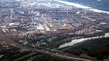
St. Peter was in the eastern part of the Upper Austrian capital Linz and bordered to the north by the districts of Lustenau , the east by the Danube separated on the communities of Steyregg and air mountain , on the south by the district Ebelsberg and in the west of the districts Kleinmuenchen and Waldegg . The area was 9.14 km² and the height 266 m above sea level. A. The greatest extent from east to west was around three kilometers, from north to south around nine kilometers. In 2012 there were only 125 apartments, but 600 buildings. This is due to the fact that voestalpine and the Linz Chemical Park are located in this area. This also explains the small number of inhabitants (0.1 percent of the Linz population).
The district and statistical district of St. Peter was bordered in the south by the river Traun and in the east by the Danube . The same applies to the cadastral community that still exists.
literature
- Günter Kaar, Manfred Carrington , Andreas Reiter: LiNZ contemporary history - from provincial to steel city, the beginning of VÖEST. Lentia-Verlag, Linz 2012, ISBN 978-3-9503469-0-9 .
- F. Dobusch, J. Mayr (Ed.): Linz - City of Work and Culture. Linz: Gutenberg Advertising Ring, 1997.
- City research Linz: CD-ROM Linz 2000. Facts, pictures, graphics. Linz, 2000.
Web links
- St. Peter - the disappeared village . Austria picture from August 9, 1998 in the ORF TV counter
Individual evidence
- ↑ a b c linz-stpeter.at: The history of the parish Linz - St. Peter , accessed on November 1, 2015
- ^ Benedikt Pillwein : History, geography and statistics of the Archduchy of Austria above the Enns and the Duchy of Salzburg. First part: the mill circle. Linz 1827, p. 246 ( books.google.de ).
- ^ Günter Kaar, Manfred Carrington , Andreas Reiter: LiNZ-Zeitgeschichte - from the provincial to the steel city, the beginning of the VÖEST. Linz 2012. p. 23 ff.
- ↑ linz.at: Statistical Districts , accessed on November 1, 2015
- ↑ a b Map with cadastral boundaries on DORIS.at , accessed on December 8, 2018.
- ↑ Statistical District 17: OrthoFoto. Archived from the original on November 30, 2012 ; accessed on November 1, 2015 .
Coordinates: 48 ° 16 ' N , 14 ° 20' E


