
Kammersee (Styria)
| Kammersee | ||
|---|---|---|

|
||
| Geographical location | Styria , Austria | |
| Tributaries | Traun origin | |
| Drain | underground → Toplitzsee … Traun | |
| Data | ||
| Coordinates | 47 ° 38 '56 " N , 13 ° 56' 38" E | |
|
||
| Altitude above sea level | 719 m above sea level A. | |
| surface | 1.5 ha | |
| length | 330 m | |
| width | 160 m | |
| Maximum depth | 18 m | |
| Middle deep | 8 m | |

The Kammersee is a small, shallow lake in the Styrian part of the Salzkammergut in Austria . The lake lies in a rock basin at an altitude of 719 m above sea level. A. at the southern end of the Dead Mountains . The water level can fluctuate by up to 10 m depending on the precipitation, but is a maximum of 18 m. Therefore the area fluctuates strongly and amounts to a maximum of 1.5 hectares. The lake drains underground into the Toplitzsee . In rainy years, the excess water flows through an artificial canal to the Toplitzsee. This drift canal to transport the wood into the Traun was completed in 1549 and is 97 m long, 2 m wide and 6 m deep. A waterfall in the northeast of the Kammersee is called the Traun-Ursprung . During the late Ice Age, the Kammersee and Toplitzsee were still part of the Grundlsee .
The Kammersee can be reached from the east bank of the Toplitzsee, which can be reached with a plate or a hat. From the landing stage, the Kammersee can be reached on foot in around five minutes.
gallery

The Kammersee

View over the Kammersee in autumn, east bank
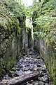
Trift Canal from Kammersee to Toplitzsee

The origin of the Traun east above the Kammersee


literature
- Harald Lobitzer: Geological walks: Ausseerland - Salzkammergut . Ed .: Publishing house of the Federal Geological Institute in Vienna with the Kammerhof Museum Bad Aussee. Vienna 2011, ISBN 978-3-85316-063-3 .
- Irene Drozdowski, Alexander Ch. Mrkvicka, Georg F. Mrkvicka: The aquatic flora of stagnant waters of the Styrian Salzkammergut (Austria) as well as comments on the occurrence of large mussels, crabs and amphibians . In: Biodiversity and Nature Conservation in Eastern Austria - BCBEA . tape 1/2 . Vienna 2015, p. 233–251 ( PDF on ZOBODAT [accessed July 18, 2020]).
Web links

Almsee | Altausseer See | Attersee | Augstsee | Dreibrüdersee | Egelsee | Elmsee | Fuschlsee | Gosau Lakes | Great Bad Sea | Großsee | Grundlsee | Hallstätter See | Lake Henar | Hinterer Lahngangsee | Hintersee | Hirzkarseelein | Irrsee | Kammersee | Little Bad Sea | Koppenwinkel lacquers | Krallersee | Langbathseen | Laudachsee | Fairytale lake | Mondsee | Nut Lake | Offensee | Ödensee | Ostersee | Salza reservoir | Schwarzensee (St. Wolfgang) | Schwarzensee (Tauplitz) | Sommersbergsee | Steirersee | Taferlklaussee | Tauplitzsee | Toplitzsee | Traunsee | Vorderer Lahngangsee | Wildensee | Wolfgangsee