
Katschberg
| Katschberghöhe | |||
|---|---|---|---|
 Katschberg, in the background the Tschaneck |
|||
| Compass direction | North | south | |
| Pass height | 1641 m above sea level A. | ||
| district | Tamsweg | Spittal an der Drau | |
| Watershed | Mur , Drava , Danube | Lieser , Drau, Danube | |
| Valley locations | Sankt Michael im Lungau | Rennweg on Katschberg | |
| expansion | B99 / motorway tunnel | ||
| Mountains | Ankogel Group / Gurktal Alps | ||
| profile | |||
| Ø pitch | 12.3% | 8.8% | |
| Max. Incline | 15% | 15% | |
| map | |||
|
|||
| Coordinates | 47 ° 3 '33 " N , 13 ° 36' 56" E | ||

The Katschberg or the Katschberghöhe ( 1641 m above sea level ) connects the Katschtal in Carinthia with the Lungau in the Salzburg region. Katschberghöhe is also the name of the settlement of the Rotte at the top of the pass, which belongs to the Carinthian municipality of Rennweg am Katschberg .
The holiday region or the Schischaukel Katschberg-Aineck ski area extends around the top of the pass .
Location and surroundings
The road over the Katschberghöhe leads from the municipality of Rennweg am Katschberg over the pass to Sankt Michael im Lungau . The border between the federal states of Carinthia and Salzburg runs at the top of the pass . It forms the transition from the Hohe Tauern ( Hafner Group ) in the west to the Gurktal Alps (Nockberge) in the east.
In addition to the Katschbergstraße (B99), which is of more regional importance today, the Katschberg is crossed by the Tauernautobahn (A10) through the Katschberg tunnel.
history
The earliest known earthquake in Austria was recorded on May 4, 1201 in Katschberg, then the Duchy of Carinthia . It is estimated to have a strength of 6.1 on the Richter scale .
The Katschberg is part of the old Radstadt - Obertauern ( Radstädter Tauernpass ) - Lungau - Katschberg - Spittal an der Drau / Millstätter See transport connection . It was probably already used as a transition by the Romans. In 1459, "a Oberstrasse" over the Katschberg was first mentioned in a document. There is evidence that mail was carried over the mountain from 1764 onwards.
Probably already by the Taurisci saw the first extensive expansions of the pass routes, you could already speak of a road. This lasted for many centuries, but when the Romans came into the country it had to be improved. In connection with the factual new construction of the road over the Radstädter Tauern by the Romans, the Katschberg also received a new, particularly bold road connection from them. In large parts it runs differently than today's road, already at Sankt Margareten im Lungau it seems to have led east of today's road through the valley of the Schindergraben. At Unterbayrdorf one gained height through the creation of switchbacks and a short eastward swing; The road then found its continuation in the grain forest . There are still two milestones there today , so there is little doubt about the route there. When crossing the ridge, however, the road did not use the actual Katschberg, which today's Landesstraße conquers, but the Lausnitzhöhe a little further east, a saddle at 1812 m on the Hafner Alm. Today, a hiking trail leads from St. Margarethen over the Esseralm to this top of the pass, which continues as a poorly traveled goods road towards Rennweg.
![]()
The road over the Katschberg, rather than the Lausnitzhöhe, as well as over the Radstadt Tauern part was a total of a single street, which the for Noricans important and Roman cities Teurnia (St.Peter in wood) with Cucullae ( Kuchl ) and Iuvavum ( Salzburg ) connected with each other and beyond that connected the northern Alpine region with the Balkans. It is significant that 2000 years later this old route experienced a renaissance when the Tauern Autobahn was built, which itself forms an important link between Germany and the Balkans .
At Moosham Castle , where the northern ramp of the Katschberg merges into the southern ramp of the Radstädter Tauern , there was a small settlement where travelers could relax and take care of themselves. There was also a small temple of the Mithras cult , which was so popular at the time and which stood in opposition to Christianity for a long time . It was found when a water reservoir was built for an apprentice dormitory between 1950–52. Sculptures, inscription stones and numerous beautiful building parts were uncovered. When excavating the cellar for the apprentice dormitory, a layer was found that was richly filled with cultural debris from Roman times. Not far from this point, numerous Roman cremation graves were found that were covered with stones. From old Roman road maps we also know the name of this place - " Immurium " - which was not far above the road on a mountain slope and from which other important routes such as to the Turracher Höhe started. At the latest at the end of Roman times, the village fell into disrepair and was soon forgotten. However, this place was not a Roman foundation: Finds show that there was settlement for at least five pre-Roman centuries. Under the Romans, the place was upgraded, more houses were built; In addition to residential buildings, there are also several inns, workshops, warehouses and even a small bathroom, and the Mithra temple mentioned above. Slag finds seem to be a clue that metallurgy was also practiced in the place; indigenous ores were certainly smelted here, which were found to be quite numerous in this area.
tourism
In 1929 J. Kastner built the first restaurant on the Katschberghöhe. On April 16, 1956, Matthias and Gertrude Bogensperger took over Kastner's restaurant and gradually expanded it into a four-star hotel. Today there are numerous hotels and holiday apartments on the Katschberg.
In 1957 Matthias Bogensperger built the first ski lift on the Tschaneck . Between 1957 and 1997 he expanded the entire ski area into one of the largest private ski areas with 10 lifts. Today the Katschberg-Aineck ski area stretches with 16 lifts and 70 km of slopes from Tschaneck (2024 m) over the Aineck (2220 m) to St. Margarethen im Lungau . In 2001 the snow-making system went into operation and the lift systems were expanded and modernized.
Winter & ski tourism
Departures
The longest ski runs are the "A1" from Aineck to St. Margarethen, the Aineck run to Katschberg (black run - known as Direttissima / Kamikaze run - or red family run) and the Tschaneck run (marked black, but mostly suitable for families).
For beginners, the pommel lift, Minijet and Königswiesenbahn on Tschaneck as well as family and spirits downhill runs on the Aineck are possible.
Lifts and cable cars
On the Katschberg there are three gondola lifts, two 6-seater high-speed chairlifts, as well as two fixed-grip 4-seater chairlifts, a 3-seater chairlift, and five drag lifts, as well as three button lifts.
Feeder
The 8-seater gondola lift Silverjet 1 acts as a feeder from the St. Margarethen valley station to the Aineck and from the Katschberghöhe to the Tschaneck the 6-seater Tschaneck high-speed railway with covers built in 2001 ends.
Other cable cars and lifts
- Carinthian side
There is also the Gamskogelexpress (6-person high-speed train with covers and conveyor belts from 2003). There is also the Königwiesenbahn (4-seater chair lift, fixed-grip year 1997) and the Sonnenalmlift (4-seater chair lift, fixed-grip year 2002 replaces a drag lift). On the Carinthian side there is the Aineckbahn (3-seater high-speed chairlift, detachable). There are also three tow and button lifts.
- Salzburg side
After there was a DSB Aineckbahn and three tow lifts on the Salzburg side up to the 2008/09 season, modernization work began from 2009 to 2018. This resulted in three new 8-seater gondola lifts, Silverjet 1, Silverjet 2 and the Aineck summit lift.
Summer tourism
With the development of the ski area, summer tourism also developed. Today there is - across the whole of Salzburg's Lungau - a network of hiking trails over 200 km as well as numerous summer activities and accommodations in the region.
photos

Sign at the top of the pass
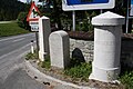
Pass summit, two boundary stones and a myriameter stone

View of Katschberg and Aineck from Tschaneck

South ramp

North ramp


literature
- Katschbergbahnen GmbH: The Katschberg. A chronicle from Dir. Norbert Loquenz .
Web links
- Katschberg / Rennweg holiday region
- Katschberg mountain railways
- Slope profile of the driveway from Kremsbrücke
- Slope profile of the St. Michael driveway
Individual evidence
- ↑ Katschberg and the surrounding area on ÖK 50 , www.austrianmap.at , Federal Office for Metrology and Surveying Austria, Austrian map, scale 1: 50,000.
- ↑ http://www.zamg.ac.at/cms/de/geophysik/lexikon/erdbeben-in-oesterreich ZAMG: Lexicon - keyword earthquake in Austria
- ↑ Sonja Burger, Martin Kugler: Hidden Signs for Earthquakes. In: Universum Magazin. Krems-Wien 2016. Issue 11/2016. ZDB ID 2092993-6 . P. 59.
- ^ Steffan Bruns: Alpine passes - from the mule track to the base tunnel, vol. 4
- ↑ Ski vacation on Katschberg - The perfect winter fun in Austria on Katschberg accessed on May 14, 2019
- ↑ Lifts Cable cars T-bar lifts Magic carpets Chair lifts in the ski area - Katschbergbahnen - More skis on Katschi accessed on May 14, 2019
- ↑ SilverJet 1 (built in 2018) in the 8-seater gondola from St. Margarethen to Aineck, accessed on December 16, 2018
- ↑ Hiking & Active Accessed on May 14, 2019
Ahorn • Alpl • Ammer • Annaberg • Arlberg • Ascher • Bieler • Birkfelder • Boding • Brenner • Buchauer • Buchener • Dientner • Dürrholzer • Eibegg • Erb • Eisental • Faschina • Feistritz • Fern • Filzen • Flattnitz • Flexen • Forsthof • Furka • Fuscher • Gaberl • Gaden wide • Gailberg • Gangleit • Geiseben • Gerichtsberg • Gerlos • Geschriebenstein • Goller • Grießen • Griffner • Large Kripp • Grubberg • Grünbacher • Gschuett • Hafner • Hahntenn • neck • Haselrast • Hebalm • stallion • Hengstl • Hiaslegg • Hirschegger • Hochegger • Hochrindl • Hochtannberg • Hochtor • Holzleiten • Iselsberg • Josefsberg • Kaiserauer • Cold Kuchl • Kartitscher • Katsch • Kernhofer • Kerschbaumer • Klachauer • Klamm • Klamml • Small Kripp • Klippitz • Klostertaler • Kraxen • Kreuth • Kreuzberg • Kühtai • Lahn • Lienbach • Loibl • Losen • Luft • Mendling • Michelbühel • Moarigraben • Nassfeld • Neumarkter • Niederalpl • Norberts • Nöring • Obdacher • Oberjoch • Och • Pack • Paulitsch • Perchauer • Pfaffen • Pfarralm • Pielachtaler • Piller • Plöcken • Pogusch • Pölshals • Pötschen • Präbichl • Prebersattel • Preiner • Pretal • Promau • Pyhrn • Radl • Radling • Radstädter • Radstatt • Rams • Raneck • Rechberg • Rieder • Rohrer • Sattler • Saurüssel • Schaida • Schanz • Scharflinger • Schiestel • Schober • Schönfeld • Schwarze Sau • Schwarzenbichl • Seeberg • Seefelder • Semmering • Kleiner Semmering • Sieggraben • Silzer • Soboth • Summer • Staller • Styrian Seeberg • Straßegg • Sölk • Thurn • Timmels • Triebener Tauern • Turracher • Origin • Wechsel • Weinebene • Weißenbacher • Wagrainer • Windische • Wurzen • Zellerrain