
Katschberg Street
| State road B99 in Austria | ||||||||||||||||||||||||||||||||||||||||||||||||||||||||||||||||||||||||||||||||||||||||||||||||||||||||||||||||||||||||||||||||||||||||||||||||||||||||||||||||||||||||||||||||||||||||||||||||||||||||||||||||||||||||||||||||||

|
||||||||||||||||||||||||||||||||||||||||||||||||||||||||||||||||||||||||||||||||||||||||||||||||||||||||||||||||||||||||||||||||||||||||||||||||||||||||||||||||||||||||||||||||||||||||||||||||||||||||||||||||||||||||||||||||||
| Basic data | ||||||||||||||||||||||||||||||||||||||||||||||||||||||||||||||||||||||||||||||||||||||||||||||||||||||||||||||||||||||||||||||||||||||||||||||||||||||||||||||||||||||||||||||||||||||||||||||||||||||||||||||||||||||||||||||||||
| Start of the street: | Bischofshofen ( 47 ° 23 ′ N , 13 ° 28 ′ E ) |
|||||||||||||||||||||||||||||||||||||||||||||||||||||||||||||||||||||||||||||||||||||||||||||||||||||||||||||||||||||||||||||||||||||||||||||||||||||||||||||||||||||||||||||||||||||||||||||||||||||||||||||||||||||||||||||||||
| Overall length: | 114.0 km | |||||||||||||||||||||||||||||||||||||||||||||||||||||||||||||||||||||||||||||||||||||||||||||||||||||||||||||||||||||||||||||||||||||||||||||||||||||||||||||||||||||||||||||||||||||||||||||||||||||||||||||||||||||||||||||||||
|
State : |
||||||||||||||||||||||||||||||||||||||||||||||||||||||||||||||||||||||||||||||||||||||||||||||||||||||||||||||||||||||||||||||||||||||||||||||||||||||||||||||||||||||||||||||||||||||||||||||||||||||||||||||||||||||||||||||||||
|
Course of the road
|
||||||||||||||||||||||||||||||||||||||||||||||||||||||||||||||||||||||||||||||||||||||||||||||||||||||||||||||||||||||||||||||||||||||||||||||||||||||||||||||||||||||||||||||||||||||||||||||||||||||||||||||||||||||||||||||||||
The Katschbergstraße (Katschberg Road, B99) is a country road in Austria and runs from Bischofshofen in the province of Salzburg to Spittal in Carinthia .
Katschberg Strasse runs almost parallel to the A 10 Tauern Autobahn and crosses two passes .
From Bischofshofen the 114 km long road leads to Radstadt im Pongau , then to Untertauern and over the Tauern Pass (highest point of the road).
The winter sports resort of Obertauern is located on the Tauern Pass . The road then runs via Tweng , Mauterndorf and Sankt Michael im Lungau to the Katschberg Pass . The Katschbergpass may not be used by trucks with trailers, articulated vehicles or vehicles with caravan trailers . The pass connects the Katschtal in the municipality of Rennweg am Katschberg in Carinthia with the Lungau in the Salzburg region and the Hohe Tauern in the west with the Gurktal Alps (Nockberge) in the east.
Via Rennweg am Katschberg and Gmünd , the road runs along the Lieser to Spittal an der Drau . The entire length of Katschbergstrasse is used by the Postbus .
history
Between 1519 and 1530 the first road over the Radstädter Tauern was set up, on which a large part of the goods transport between Salzburg and Venice was handled. From 1749 to 1753 this driveway was expanded into a road .
The Carinthian street (in Salzburg) or Salzburgerstraße (in Carinthia) belongs to the former imperial roads that were taken in 1921 as federal highways. Until 1938 this federal road was designated as the B 62, after the connection of Austria it was run as part of the Reichsstraße 331 until 1945 .
Because of the gradients of up to 18%, the Katschberg was previously feared by drivers. In the summer months, there were many cars with boiling cooling water on the roadsides. In the years 1956 to 1958, the road was defused, modernized and paved. The Katschberg is with an average gradient of 12.3% over 5 km in the north ramp, 11.9% over 3 km in the south ramp and maximum gradients of 15% in both ramps, viewed from the top of the pass, as well as some very tight turns and curves are difficult to negotiate even today.

On August 12, 2017 at around 10:30 p.m. there was a rock fall of around 5000 m³ of rock at a location between Kreuzbergmaut and Pöham at a point with an approximately 45-year-old rock protection (by adjacent shotcrete). The road was buried over a length of 50 meters. The A10 Tauern motorway and the ÖBB train route through the Fritztal were not affected by this rock fall.
Pictures from the Carinthian section

Road north below the Katschberghöhe

Road south below the Katschberghöhe
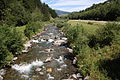
Street next to the Lieser south of Rennweg am Katschberg


Web links
Individual evidence
- ^ Official Austrian map
- ↑ Division of the Alps, No. 46a on the map
- ^ Federal law of July 8, 1921, regarding federal highways. Federal Law Gazette No. 387/1921.
- ↑ B99 “Certainly not open next 14 days” orf.at, August 14, 2017, accessed August 14, 2017.
- ↑ Bundesstraße buried up to 20 meters high salzburg.orf.at, August 13, 2017, accessed August 14, 2017.
| B99 | Like the other former federal highways, Katschberg Strasse was part of the federal administration. Since April 1, 2002, it has been under state administration and continues to have the B in the number, but not the name Bundesstraße. |