Lieser (Drava)
| Readers | ||
|
Liesergraben near Seebach / Seeboden around 1920. |
||
| Data | ||
| location | Carinthia ( Austria ) | |
| River system | Danube | |
| Drain over | Drau → Danube → Black Sea | |
| source | rear Pöllatal | |
| Source height | approx. 1900 m above sea level A. | |
| muzzle |
Drau near Spittal an der Drau Coordinates: 46 ° 46 ′ 52 " N , 13 ° 29 ′ 58" E 46 ° 46 ′ 52 " N , 13 ° 29 ′ 58" E |
|
| Mouth height | 529 m above sea level A. | |
| Height difference | approx. 1371 m | |
| Bottom slope | approx. 27 ‰ | |
| length | 50 km | |
| Catchment area | 1,036.3 km² | |
| Discharge at the Spittal gauge (Fasan) A Eo : 905.2 km² Location: 3.18 km above the mouth |
NNQ (03/05/1996) MNQ MQ Mq MHQ HHQ (09/02/1965) |
1.99 m³ / s 5.92 m³ / s 21.6 m³ / s 23.9 l / (s km²) 176 m³ / s 400 m³ / s |
| Right tributaries | Malta | |
| Medium-sized cities | Spittal an der Drau | |
| Small towns | Gmünd in Carinthia | |
| Navigable | World championship course whitewater | |
|
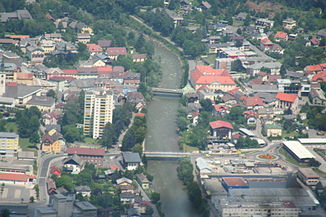
Lieser in Spittal |
||
The Lieser is a 50 km long river in Carinthia .
course
It rises in the rear Pöllatal (Lieser origin) in the Hafner group , first flows through the Pöllatal (nature reserve) and then through the Katschtal before it joins the Malta at Gmünd . From then on it flows through the Liesertal , absorbs the water from the Millstätter See and finally flows into the Drau below Spittal .
meaning
The name Lieser is one of the oldest names in Carinthia, as rivers were the most important means of orientation in ancient times. The name is derived from Indo-European * (E) Lesura derived which Liebental means.
The entire length of the Lieser forms the border between the Nock Mountains, the southwestern part of the Gurktal Alps and the Hohe Tauern . Its catchment area in the upper reaches largely coincides with the former judicial district of Gmünd . The entire course can be used as fishing water.
Floods
On September 11, 1903, there was a very severe thunderstorm with rain, snow and storms, especially in the Malta and Lieser valleys. A mudslide dammed the Maltabach in front of the "Blauen Tumpf" in the Maltatal . A water and debris avalanche developed from this, which caused enormous damage along Lieser and destroyed 13 km of Gmündner Strasse. Both the bridge in Lieseregg and Seebach were destroyed. The event was described by the dialect poet Franz Podesser from Tangern in the epic "Die Große Gieß". The disaster in 1904 led to the Lieser regulation between Grud and Seebach. The new road to Gmünd was only opened in November 1905. The provisional "Kirchsteig" near Lieseregg existed from 1904 until 1956 when a concrete bridge was built.
White water sports
Your lower course in the Liesergraben, which cuts through the Millstätter See ridge , is a demanding white water route for canoeists. The first kayak competitions were held here in 1960 . In 1961 the canoeing section was founded in the Spittal sports community. In 1963, 1965 and 1977 canoe world championships were held on this Lieser section. The Lieser Canoe School was founded in 1992. The route was very well visible to spectators thanks to the road that ran directly along the river. The infrastructure for canoe competitions no longer exists, but canoeists from home and abroad still use the river.
Power plant project
The plans for a power plant project that became known in March 2010, a water catchment in Lieserbrücke with a pipeline in the federal highway B99 and a power plant near Marienheim, provoked protests from previous users (fishermen, paddlers) who founded a "Lieser interest group".
Web links
- Hydrographic service in Carinthia - online measurement data
- Info page for kayakers with photos
- Report on a kayak tour on the Lieser
- Non-partisan interest group for the preservation of the Lieser
Individual evidence
- ↑ Federal Ministry of Agriculture, Forestry, Environment and Water Management (Ed.): Area directory of the Austrian river basins: Draugebiet. Contributions to the hydrography of Austria, issue No. 59, Vienna 2011, p. 40 ( PDF; 3.5 MB )
- ↑ Federal Ministry for Agriculture, Forestry, Environment and Water Management (Ed.): Hydrographisches Jahrbuch von Österreich 2011. 119th Volume. Vienna 2013, p. OG 337, PDF (12.9 MB) on bmlrt.gv.at (yearbook 2011)
- ^ Eberhard Kranzmayer: Place name book of Carinthia . Part I, 1956, p. 20.
- ↑ Edi Rauter: Seeboden. A health resort on Lake Millstatt. Carinthia Verlag, Klagenfurt, 1976, ISBN 3-85378-015-6 , p. 19.
- ↑ Stöflin, Helmut: Planned power plant on the Lieser "electrifies". In: Kleine Zeitung, March 22, 2010 ( Memento from June 12, 2010 in the Internet Archive ), accessed on March 24, 2010.

