
Hafner group
| Hafner group | |
|---|---|
 View of St. Michael ; in the middle behind the Hafner group |
|
| Highest peak | Großer Hafner ( 3,076 m above sea level ) |
| location | Carinthia and Salzburg , Austria |
| part of | Ankogel Group , Central Eastern Alps |
| Coordinates | 47 ° 4 ' N , 13 ° 24' E |
The Hafner Group is a mountain group in the Hohe Tauern . It is the easternmost subgroup of the Ankogel group .
Location and landscape
The border between Carinthia ( Spittal district ) and Salzburg ( Lungau , Pongau ) and the watershed between Mur and Salzach ( Grossarltaler Ache ) in the north and Lieser and Malta in the south run through the Hafner ridge between Arlscharte and Katschberg .
The group includes the easternmost three-thousand-meter peaks in the Alps: the highest and eponymous summit is the Große Hafner ( 3,076 m above sea level ). Other high peaks are Lanischhafner ( 3018 m above sea level ), Lanischeck ( 3022 m above sea level ), Gr oßer or Malteiner Sonnblick ( 3030 m above sea level ) and Mittlerer Sonnblick ( 3000 m above sea level ).
The Pöllatal , which divides the eastern part into two ridges, runs through the middle of the Hafner Group , a northern, sharper ridge of the Kareck ( 2481 m above sea level ) to the Katschberg, and a larger southern train with the Schober ( 2976 m above sea level) . ), which runs towards Gmünd .
The southwestern part of Hafner group by the Malta High Alpine Road opened up, originally a Kraftwerkstraße the Malta power plant . On the Lungau side there are several small Keese lakes and the Rotgüldensee , which has been expanded to become the Lungau power plant group's reservoir .
Communities
Mining
Place and field names such as Hüttschlag , Rotgülden , Eisentratten and Waschgang (a mountain peak) testify to earlier mining, as do the Eisentratten blast furnace, the Oberdorfer stamp mill and mouth holes .
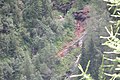
Former arsenic mines below the Rotgüldensee

The name Hüttschlag and the coat of arms with the Venus symbol (as a symbol for copper ), mallets and iron refer to the mining industry

2.JPG)


Refuges

photos
View from Weinschnabel (Hafnergruppe) to Hochalm and Ankogel

Murtal near Muhr ; Hafnergruppe on the left, Niedere Tauern on the right

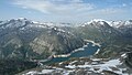
Upper Maltatal with Kölnbreinspeicher Left Hafner Group, right Hochalm Group

Karwassersee in the rear Mur valley
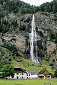
Fallbach in the Maltatal, with Fallbach via ferrata

Larch grove in the Pöllatal


literature
- Christof Exner : Geology of the peripheral Hafner group (Hohe Tauern). In: Yearbook of the Federal Geological Institute , Volume 114 (1971), pp. 1–119 ( article pdf , geologie.ac.at).
- Christof Exner: Geology of the central Hafner group (Hohe Tauern). In: Jahrbuch der Geologische Bundesanstalt , Volume 125, Issue 1–2 (1982), pp. 51–154, PDF on ZOBODAT
Web links
- Entry on Hafnergruppe in the Austria Forum (in the AEIOU Austria Lexicon )
Individual evidence
- ↑ Entry on Hafnergruppe in the Austria Forum (in the AEIOU Austria Lexicon )
- ^ Lungau mining history: Rotgülden