
Muhr (Salzburg)
|
Muhr
|
||
|---|---|---|
| coat of arms | Austria map | |
 |
|
|
| Basic data | ||
| Country: | Austria | |
| State : | Salzburg | |
| Political District : | Tamsweg | |
| License plate : | TA | |
| Main town : | Front clock | |
| Surface: | 116.07 km² | |
| Coordinates : | 47 ° 6 ' N , 13 ° 30' E | |
| Height : | 1107 m above sea level A. | |
| Residents : | 487 (January 1, 2020) | |
| Population density : | 4.2 inhabitants per km² | |
| Postal code : | 5583 | |
| Area code : | 06479 | |
| Community code : | 5 05 05 | |
| NUTS region | AT321 | |
| Address of the municipal administration: |
Front watch 5 5583 Muhr |
|
| Website: | ||
| politics | ||
| Mayor : | Hans-Jürgen Schiefer ( ÖVP ) | |
|
Municipal Council : ( 2019 ) (9 members) |
||
| Location of Muhr in the Tamsweg district | ||
  |
||
 The Muhrtal, into the valley |
||
| Source: Municipal data from Statistics Austria | ||

Muhr is one of the 15 municipalities in the Tamsweg (Lungau) district, State of Salzburg in Austria and has 487 inhabitants (as of January 1, 2020). The - almost - same-named river Mur rises in the municipality .
geography
The municipality covers the uppermost Mur valley. “Upper Murtal” can also be understood to mean the whole of Lungau in a broader sense - Upper Murtal specifically refers to the Styrian section to Bruck an der Mur. Here, Murtal is understood to mean in particular the section from St. Michael via Ramingstein to the state border at Kendlbruck / Predlitz, which as a valley widening from St. Michael to Tamsweg represents the core area of the Lungau and can also be seen as part of the Lungau basin . In order to identify the valley of Muhr as one of the side valleys of this core area, the term Muhrtal - like the municipality in the old spelling with "h" - has become naturalized.
As is customary in the area, the Talung is simply called the Muhr , as is often the case in Upper Germany .
The name Murwinkel is also found . This old field name originally referred to the parish, i.e. the area around St. Rupert and the Rotgülden mining region . It can be found both for the entire Muhr valley in the sense of the municipality, also corresponding to the present-day localities of Vorder- and Hintermuhr as Vorderer and Hinterer Murwinkel , and especially for the uninhabited uppermost valley above Rotgülden.
The Muhrtal measures around 20 kilometers. In its outer part it forms a continuation of the Mur-Mürz furrow , and around Schellgaden still an extension of the Lungau basin. It stretches westwards a little south of St. Michael at the foot of the Katschberg . It then leads uphill via Hemrach and the Vordermuhr ; the latter is divided into Lower and Upper Au . About halfway along it is divided by the Murfall , from this area onwards one speaks of Hintermuhr . Here the Altenberg valley branches off to the southwest. From Rotgülden it leads more north-west and forms the Murwinkel in the narrower sense. Here southwest branches the Rotgüldental to Rotgüldensee from. At Jagdhaus Muritzen there is another side valley, the Muritzental with the Karwassersee . At the Sticklerhütte the valley of the Mur - still seen towards the valley - bends southwest. The very bottom part is then called the lard pit . Here rises at the foot of the Murecks the Mur ( Murursprung ).
The ridge to the north is the Weißckgruppe of the Radstädter Tauern , with the Weißeck ( 2711 m above sea level ). Behind it lies the Zederhaus valley as a neighboring valley to the Muhr valley. To the south lies the Hafner group of the Ankogel group , with the Kareck ( 2481 m above sea level ) above the Katschbergpass and the Großer Hafner ( 3076 m above sea level ) as the main summit. This ridge is the Salzburg-Carinthian state border, behind it is the Pöllatal , the uppermost valley of the Lieser , in the south, and the uppermost Maltatal around the Kölnbrein reservoir in the west . The ridge of the Schöderhorn ( 2475 m above sea level ) connects the two mountain ranges, over it the Murtörl leads to the Pongauer Großarltal . This ridge belongs to the main Alpine ridge , and the Murtörl separates the Hohe Tauern , to which the Hafner belongs, from the Niedere Tauern , to which the Weißeck is counted.
Community structure
The municipality includes the following three localities and cadastral communities (population in brackets as of January 1, 2020):
- Hintermuhr (82) at the head of the valley, with Jedl , Reit , Rotgülden and Unterm Fall
- Schellgaden (61) out of the valley, with Hemerach
- Vordermuhr (344) with Laas , the Kirchweiler Muhr , Obere Au , Untere Au
The only counting area is Muhr for the entire municipality.
The community belongs to the judicial district of Tamsweg . Until the end of January 1962 she belonged to the judicial district of Sankt Michael im Lungau .
The community cooperates with the other Lungau communities and the neighboring Carinthian communities in the UNESCO Biosphere Park Salzburg Lungau and Carinthian Nockberge . It also belongs - as the only Lungau community - to the national park communities Hohe Tauern National Park .
Neighboring communities
| Cedar house | ||
| Hüttschlag ( District St. Johann (Pongau) ) |
.svg)
|
Sankt Michael im Lungau |
| Malta ( District Spittal , KTN ) | Rennweg am Katschberg ( District Spittal , KTN ) |
history
There is no evidence of the settlement until Roman times, which is well preserved in the Lungau core area.
From the Middle Ages, the Muhr valley was an important mining region . Already in the later High Middle Ages , in the middle of the 14th century, the gold mining Schellgaden and the arsenic mining Rotgülden can be proven. They were run by the Salzburg archbishops . The heyday of mining falls into the 16th century, at that time 150 mining sites were known by name. The Rupert Church in Muhr (ecclesia s. Ruperti in valle mur) can also be documented in 1523 . In 1670 a vicariate of St. Michael was established.
In 1813 the former Michael Vicariate was elevated to the parish of Muhr im Lungau (originally Murwinkel ). While gold mining in Schellgaden ended in 1818, the Rotgülden mine was still the largest arsenic mine in the Habsburg monarchy at the end of the 19th century .
Production in the arsenic smelter was stopped in 1994. The British mining company Noricum Gold stopped the multi-year gold search for the former Rotgülden gold mine in May 2015 for cost reasons. Several test boreholes had been driven to a depth of 150 m.
On 29./30. In October 2018 the low-lying town center was flooded by the rising Mur after heavy rainfall .
coat of arms
Blazon: a shield, diagonally divided by a double wavy band in blue, above in the left field in silver a man with red-silver clothes, on the right a sword, on the left holding a gold ring with ruby, below in the right field in gold a blahhaus in Black.
The man is the local Samson . Blahhaus means a small blast furnace and refers in particular to the arsenic mining Rotgülden .
politics
The community council has a total of 9 members.
- With the municipal council and mayoral elections in Salzburg in 2004, the municipal council had the following distribution: 5 ÖVP, 3 SPÖ, and 1 FPÖ.
- With the municipal council and mayoral elections in Salzburg in 2009 , the municipal council had the following distribution: 4 SPÖ, 4 ÖVP, and 1 FPÖ.
- With the municipal council and mayoral elections in Salzburg in 2014 , the municipal council had the following distribution: 4 SPÖ, 4 ÖVP, and 1 FPÖ.
- With the municipal council and mayoral elections in Salzburg in 2019 , the municipal council has the following distribution: 5 ÖVP, 3 SPÖ, and 1 FPÖ.
- mayor
- until 2004 Hans Hohenwarter (ÖVP)
- 2004–2009 Hubert Gruber (ÖVP)
- 2009–2019 Ernst Josef Kandler (SPÖ)
- since 2019 Hans-Jürgen Schiefer (ÖVP)
economy
The power plants are located in the municipality of Muhr Murfall , Rotgülden and Hintermuhr the power plant group Lungau of Salzburg AG , the infrastructure company of the city of Salzburg for energy, transport and telecommunications.
The 300 km Mur Cycle Path through Austria begins in Muhr . A rough, ultimately very steep, gravel road leads up to the Sticklerhütte . A rather flat hiking trail runs right up to the source of the Mur in the Kar. On the shady side, in the Hafner group, lies the Rotgüldenseehütte .
Culture and sights
- Prangstangen
- The giant figure of Samson
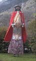
The Samson von Muhr

View of the town of Muhr

Chapel - in the background the church

Church tower in Muhr


Web links
- Community website
- 50505 - Muhr. Community data, Statistics Austria .
- Muhr . In: Salzburger Nachrichten : Salzburgwiki .
Individual evidence
- ↑ The Mitterberg is viewed as an island mountain in the pelvic area.
-
↑ a b (FC Weidmann, Hrsg. :) Tourist manual on excursions and hikes in Salzburg. Volume 1 (first main part, general overview. City of Salzburg, surroundings of the city, Pongau and Lungau. ), Verlag Carl Gerold, Vienna 1845, section Die Thauerntäler des Pongau's and Lungau’s , 7. Murwinkel and Murthal (Lungau) , pp. 290-303 ( Google eBook, full view ):
“From the wall [di: Wendung] on the Roßkogl to the Blasnerlehen [near Rotgülden], the valley bears the name of the Murwinkel . [...] The brook [...] flows past the place Mur , St. Michael and Tamsweg, [...] and thus forms the main valley of the Lungau, which from the Blasnerlehen, where the Murwinkel takes the name Murthal , ... "(quote p . 292). - ↑ something like: Peter Holl: Niedere Tauern. Alpine Association Guide series : Zentralalpen , Bergverlag Rother, 2005, ISBN 978-3-7633-1267-2 , On the geography of the Niedere Tauern , p. 18 and valleys and valley locations: Murtal , p. 396 f and Muhrtal , p. 397 f.
- Jump up ↑ For example: Christian Steinwender, Lukas Plan: Kontaktkarst in the Murursprung-Rosskar area (Lungau, Salzburg). In: Die Höhle 62 (2011), pp. 15–26, PDF on ZOBODAT “the Muhr (the valley in which the source of the Mur lies)…” (citation p. 16 below).
- ↑ Entry on Murwinkel in the Austria Forum (in the AEIOU Austria Lexicon ): “top piece of the Mur valley ”.
-
↑ a b For example: Benedikt Pillwein (Ed.): History, geography and statistics of the Archduchy of Austria above the Enns and the Duchy of Salzburg . With a register, which is also the topographical and genealogical lexicon and the district map. Geographical-historical-statistical detail according to district commissariats. 1st edition. Fifth part: the Salzburg district . Joh. Christ. Quandt, Linz 1839, Chapter 17) Nursing Court St. Michael , p. 480 ( Google eBook - Faks. Druckhaus Nonntal, Salzburg 1983). 2nd edition 1843 ( Google Book )
also tourist handbook 1845, p. 294: "Mur (actually Murwinkel) is a parish ..." -
↑ For example: Adolph Schaubach: The German Alps. Volume 1, Verlag F. Frommann, 1845, Chapter I) The Central Alps , 4. The Muhrtaler Alps , 1) The Lungau Alps , especially p. 100 (Chapter I.4 from p. 98; Google eBook, full view ) :
"The center of the country falls in the area of St. Michael and Tamsweg and there the inner ridges converge, as do the valleys between them: Murwinkel, Zederhaus, Tweng, Weißbriach, Lignitz, Göriach, Lessach and Leisnitz." The author then speaks of “Schellgaden im Murwinkel”. - ↑ a b c d e Historisches, on vs-muhr.salzburg.at (accessed November 14, 2016).
- ↑ The location Unterm Fall belongs to Hintermuhr.
- ↑ Statistics Austria: Population on January 1st, 2020 by locality (area status on January 1st, 2020) , ( CSV )
- ↑ The mining history of Schellgaden. In: taurachsoft.at: Lungau mining history
- ↑ a b The arsenic mining in Rotgülden. In: taurachsoft.at: Lungau mining history
- ↑ Parish, on vs-muhr.salzburg.at (accessed November 14, 2016).
- ↑ Joseph Ernst von Koch-Sternfeld (Ed.): Salzburg and Berchtesgaden in historical-statistical-geographical and state-economic contributions. Verlag Mayr, 1810, pp. 294 and 323 ( Google eBook, full view ).
- ↑ Muhr parish in Lungau. Archdiocese of Salzburg: kirchen.net → Who can I find where? (accessed November 14, 2016).
- ↑ Gold prospecting in Lungau discontinued. ORF.at, May 11, 2015 (accessed May 11, 2015).
- ↑ Tens of thousands of households without electricity orf.at, October 30, 2018, accessed October 30, 2018.
- ↑ Hans Hohenwarter . In: Salzburger Nachrichten : Salzburgwiki .
- ↑ Ernst Josef Kandler . In: Salzburger Nachrichten : Salzburgwiki .

Göriach | Lessach | Mariapfarr | Mauterndorf | Muhr | Ramingstein | St. Andrä | St. Margarethen | St. Michael | Tamsweg | Thomatal | Tweng | Unterberg | Weißpriach | Cedar house
Salzburg:
Krimml |
Wald im Pinzgau |
Neukirchen am Großvenediger |
Bramberg am Wildkogel |
Hollersbach im Pinzgau |
Mittersill |
Uttendorf |
Kaprun |
Fusch an der Großglocknerstrasse |
Rauris |
Bad Gastein |
Hüttschlag |
Muhr |
Carinthia:
Malta |
Mallnitz |
Obervellach |
Heiligenblut am Großglockner |
Großkirchheim |
Mörtschach |
Winklern |
Tyrol:
Iselsberg-Stronach |
Dölsach |
Nussdorf-Debant |
Kals am Großglockner |
Matrei in East Tyrol |
Virgen |
Prägraten am Großvenediger |
Hopfgarten in Defereggen |
St. Veit in Defereggen |
St. Jakob in Defereggen
(clockwise)
Cadastral communities and localities: Hintermuhr | Schellgaden | Front clock
Villages: Obere Au | Lower Au • Hamlet: Laas | Reit • Rotten: Hemerach | Jedl | Muhr | Schellgaden | Unterm Fall • Scattered houses: Rotgülden • Other localities: Almfried | Cavern power plant | Sticklerhütte | Rotgüldenseehütte
Counting district: Muhr