
Salzburg Lungau and Carinthian Nockberge
|
Salzburg Lungau Biosphere Park and Carinthian Nock Mountains
|
||
| location | Lungau / Upper Carinthia | |
| Area / extent | 1490 km² / 54 km | |
| Identifier | - | |
| Geographical location | 47 ° 0 ' N , 13 ° 43' E | |
|
||
| Sea level | from 300 m to 3000 m ( ø 1650 m) | |
| Setup date | July 11, 2012 | |
| administration | Nockberge Biosphere Reserve, Reichenau plain ; Regional association Lungau, Mauterndorf | |
| particularities | partly former Nockberge National Park | |

In July 2012 , the Salzburg Lungau and the neighboring Carinthian Nockberge were designated as a biosphere reserve by UNESCO . It covers the entire Tamsweg (Lungau) district of Salzburg and the adjacent areas of the Nockberge in Carinthia. This makes the area on the border between the federal states of Salzburg and Carinthia a “model region for sustainable development”.
location
The biosphere reserve comprises areas in the Liesertal , the uppermost Gurktal , and the headwaters of the Mur , with parts of the Nockberge in the Carinthian-Salzburg-Styrian border area, and parts of the Niederen and Hohen Tauern .
Its southern border is the region valley , where it still includes the eastern end of Lake Millstatt and the Wöllaner Nock , and the Kleinkirchheimer valley . In the east, the Großer Speikkogel , Turracherhöhe , and the peaks of Königstuhl (Dreiländereck), Gstoder and Preber belong to the reserve. In the north the main Alpine ridge is the border, with Hochgolling in the Schladminger Tauern , the Obertauern area spared, Mosermandl of the Radstädter Tauern , and Murtörl . Then it borders in the southwest in the Hafner group of the Hohe Tauern, from the Hafner over the Katschberg , the Innerkrems westward and to the Karlhöhe , then southward through the Drehtal , and over Millstätter Alpe to Millstättersee.
The biosphere park is 1490 km², 2 ⁄ 3 (almost 990 km²) in the Salzburg part, 1 ⁄ 3 in Carinthia, and extends to altitudes of 300 to 3000 m above sea level. A.
Around 26,000 people live in the biosphere region, around 20,700 of them in Salzburg. The main locations are Tamsweg , Mauterndorf , Sankt Margarethen im Lungau and Bad Kleinkirchheim in Carinthia. In addition to all Lungau municipalities , Krems in Carinthia , Radenthein and Reichenau also have shares.
history
Nockberge National Park
|
former Nockberge National Park
|
|
 Overview map of the former national park area (Carinthian part of the biosphere reserve) |
|
| location | Upper Carinthia , Nockberge |
| Area / extent | 184 km² / 23.3 km |
| Geographical location | 46 ° 53 ' N , 13 ° 40' E |
| Setup date | 1987 |
| particularities | dissolved in 2012 |
Originally , a ski area was planned in what is now the core zone of the Nockberge since the early 1970s, when the region was opened up with the Tauern motorway . In 1979 the construction of the Nockalm Road , which connected the Liesertal with the uppermost Gurktal, began. It was supposed to open up the Nockberge for tourism and was expanded to a continuously paved, toll road by 1981.
The plans to develop what is now the core area of Carinthia with, among other things, 18 cable cars and lifts as well as two hotel villages with a total of 3,000 beds on both sides of the Nockalmstrasse met with little approval from the population. A citizens' initiative carried out a referendum, which on December 7, 1980 resulted in a 94% vote against this type of tourism. Instead, ski areas emerged in Innerkrems and on the Turracher Höhe .
The Nockberge National Park was opened on January 1st, 1987. In the ordinance of the Carinthian provincial government of 1987 it said among other things:
- The national park should be preserved in its complete or extensive originality for the benefit of the population of the region and the Republic of Austria, for the benefit of science and to promote the regional economy.
- The flora and fauna characteristic of the national park, including their habitats and its historically significant objects and parts of the landscape, should be preserved.
- The national park should enable as large a group of people as possible an impressive natural experience in the future.
It covered 184 km² (47% Krems, 23% Bad Kleinkirchheim, 21% Radenthein, 9% Reichenau), of which 77.3 km² core zone with alpine areas and summit zones and 106.7 km² outer zone with the extensive mountain forest level (these were divided into core and Care zone of the biosphere reserve converted).
Although it was established as a national park , the protected area was not classified as IUCN Category II ( English National Park ) by the IUCN , but as Protected Landscape (Category V), because the Nockberg area has only minimal non-anthropogenic landscapes and the national park management is on preservation traditional alpine farming throughout the area. The protected area therefore did not fit into the IUCN scheme of Category II, which focused on species and ecosystem protection (making it publicly accessible).
On November 16, 2004, the Carinthia National Park Committee passed the unanimous decision to convert the National Park into a biosphere reserve based on the UNESCO concept. In these areas, a close connection between man and nature and sustainable development are paramount, and the protection goals are extended to include cultural assets much more comprehensively .
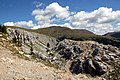
Mountain landscape on the Nockalm

The western part with Liesertal
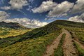
Hiking trail above St. Oswald

Southern end of the biosphere region on Lake Millstatt


Lungau holiday region
Due to its isolated location, the Lungau has always been an economically weak region, even when winter sports tourism began to develop in the 1970s, it was blocked by the highly prominent Salzburg ski areas (today's Ski amadé ) and is also poor in snow for climatic reasons. Apart from the important Obertauern ski center , only smaller ski areas developed: Katschberg – Aineck , Großeck – Speiereck and Fanningberg in the central area of Lungau, as well as Thomatal – Schönfeld . The Lungau is also an insider tip in summer mountain tourism. The expansion of the Hohe Tauern National Park in 1991 (Ankogel Group) only proved to be an economic engine to a limited extent, the Lungau has only a small share of the National Park and the centers are in the Oberpinzgau (Mittersill, Krimml). Turning to gentle tourism and the cultural peculiarities of the Lungau was the guiding principle from the 1990s.
In 1997, the Lungau region holiday region was set up on the initiative of the cultural manager Johann Bogensberger, former mayor of Ramingstein . The fact that the region (the Tamsweg district) is also otherwise closed has also been anchored in the new Salzburg spatial planning (ROG 2009), where the district represents a planning region and a community association .
Only the areas around the Obertauern region, which is used intensively for tourism, were excluded from the biosphere reserve project.

Riedingtal Nature Park with Mosermandl
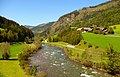
Murtal near Ramingstein
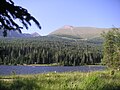
The Prebersee with Preber


Establishment of the common biosphere reserve
When the conversion of the national park in Carinthia became ripe, negotiations began to jointly plan the biosphere reserve in both federal states so that the region between the tourist hotspots Salzachtal – Ennstal and the Upper Carinthian Lake District does not continue to fall apart on the Katschberg. The establishment of cross-border biosphere reserves is one of the declared goals of the MAB program. The Styrian Sölktäler Nature Park (created 1977–1983), which also relies on gentle tourism, is an adjacent strategic partner.
UNESCO recognized it as a biosphere reserve (the designation as a "biosphere reserve" is an Austrian specificity ) in July 2012 as the Salzburg Lungau and Carinthian Nockberge biosphere reserve . On the Carinthian side, the National Park Act was changed to a National Park and Biosphere Park Act (K-NBG), and the biosphere reserve was thus also anchored as a state-legal class (as the second federal state after Vorarlberg). On the Salzburg side, the park is a voluntary municipal cooperation supported by the association of municipalities , but not a nature conservation category. The program is intensively supported by the Salzburg state government (in the form of a funding agreement).
Especially the great support in Salzburg, where the project was promoted at community level, as well as within the former national park administration, fully corresponds to the requirement of UNESCO that protected areas of the MAB program must be anchored intensively in the self-image on site, because only that the implementation of the Guiding principles guaranteed in the long term.
Management and administration
The focus of the Man and Biosphere Program (MAB) of UNESCO is nature conservation and tourism as well as sustainable regional development , with which the park follows the more modern models of the Seville Strategy and Madrid Action Plan. Biosphere reserves are primarily model regions for overcoming problems at the beginning of the 21st century with regard to climate change, globalization and the loss of diversity in ecology and culture.
The biosphere reserve only has a relatively small core zone (UNESCO requires a minimum of 5% of the area). In addition, because the area consists of valley areas, these are mostly on the edge of the biosphere reserve, but are buffered by adjacent protected areas in Salzburg's Pongau , in Styria and in Upper Carinthia. It consists of four zones, on the one hand the summit regions of the Nockberge in the border triangle ( Rosennock , Kollernock , Hohe Pressing ) and the valley ends of Krems and Mühlbach (continuation in Styria through protected areas), on the Speikkogel (larger nature reserve) in the east, the Lungau parts at the Hohe Tauern National Park in the west (where continuation is guaranteed), and the summit regions of the Hochgolling massif in the north (protected areas of Styria).
The maintenance zone includes all mountain areas (40% in Lungau, comparable in Carinthia), the development region the populated valleys.
The biosphere reserve management is based in Ebene Reichenau 117 for Carinthia (former national park administration) and at the Lungau regional association in Mauterndorf , Markt 89, for Salzburg.
natural reserve
The biosphere reserve is not entirely covered by other protection categories.
In the biosphere reserve are:
- European protection area Nockberge National Park (core zone) , GGB / FFH , ( Ktn.ESG AT2102000 , 7744 ha) - core / maintenance zone (corresponds to the abandoned national park)
- Parts of the National Park and European Protected Area Hohe Tauern ( NP 1981 , ESG Salzburger Teil , GGB / FFH and BGS / VS , AT3210001 , portion approx. 1,700 ha, of which approx. 1,400 ha from its core zone) - core zone
- Rosanin nature reserve ( Sbg.NSG00011 , 1,116 ha) - core zone
- Riedingtal Nature Park ( Sbg.NPK00002 , 2,671 ha, in LSG00036) - maintenance zone
- Parts of the Gurkursprung nature reserve (Ktn. NSG.023 , share approx. 500 ha) - core / maintenance zone
- Landscape protection area Niedere Tauern ( Sbg.LSG00059 , 19,699 ha) - maintenance zone
- Most of the Lantschfeld, Oberes Zederhaustal, Oberes Murtal protected landscape areas ( Sbg.LSG00036 , approx. 19,200 ha of the area) - maintenance zone (the remaining part is the non-integrated area on Obertauern)
- Bundschuhtal landscape protection area ( Sbg.LSG00028 , 2,218 ha) - maintenance zone
- Landscape protection area Priedröf (Ktn. LSG.076 , 1,631 ha) - development zone
- Innerkrems landscape protection area (Ktn. LSG.027 , 505 ha) - development zone
- Landscape protection area Turracher Grünsee (Ktn. LSG.024 , 68 ha) - development zone
- Parts of the Obertauern plant protection area ( Sbg.PSG00002 , portion approx. 300 ha, in LSG00036 and 59) - maintenance zone
There are also numerous small areas of various categories and local protection objects such as natural monuments. This means that around 52,000 hectares are also subject to regional protection, which is 1 ⁄ 3 of the reserve area. In addition, the alpine region is in principle protected from interference, as are all bodies of water and their banks . 9,500 ha (6%, the European protected areas) are also of international interest, and the entire biosphere falls within the protection zone of the Alpine Convention .
Adjacent (clockwise from the national park area):
- Landscape protection area Hüttschlager Talschluss ( Sbg.LSG00032 )
- Landscape protection area Obertauern ( Sbg.LSG00041 )
- European protected area Niedere Tauern ( BSG / VS , Styria AT2209000 / No. 38 )
- Landscape protection area Schladminger Tauern (Styria LS11 , largely ESG)
- Protected landscape part of Zinkwand – Vötternspitz (Styria GLT 156 small area in ESG / LSG)
- Sölktäler Nature Park (Styria No. 15 , ESG / LSG)
- European protection area high elevations of the south-eastern Schladminger Tauern (FFH, Styria AT2209003 / No. 40 ) / nature reserve Klafferkessel (Styria NSa 11 )
- Krakau-Schöder nature reserve (Styria NSa 15 , ESG / LSG)
- European Protected Area Upper and Middle Rivers of the Mur (FFH, Styria AT2236000 / No. 5 )
- European protection area parts of the Styrian Nock area ( AT2219000 / No. 32 ) / Styrian Nockberge nature reserve ( Styrian NSGc 53 )
- Landscape protection area Turracher Schwarzsee (Ktn. LSG.024 )
- Landscape protection area Hochrindl-Seebachern (Ktn. LSG.069 , south of the NSG Gurkursprung )
- Landscape protection area Millstätter See-Süd (Ktn. LSG.069 )
- Landscape protection area Outer Pöllatal (Ktn. LSG.004 )
- European protected area Inneres Pöllatal ( FFH , Ktn.AT2108000 , NSG.019 )
The adjacent Styrian areas stretch far east and connect to the large protected areas of the Limestone Alps . With these and the national park, the biosphere park is integrated into a complex of protected areas, which today stretches largely closed from the eastern edge of the Alps near Vienna to far into Switzerland ( Econnect project ), and closes an important gap in order to also connect the southern Alps .
Protected cultural asset
Originally settled in Slavic and then Bauiuwar , the entire region belonged to Carinthia in the High Middle Ages . The rule of Gmünd came to the diocese of Salzburg in 1142 , the county of Lungau in 1248, then also the rule of Rauchenkatsch . In 1535 Gmünd and in 1605 the Rauchenkatsch returned to Carinthia, and thus to Austria , but the Lungau remained Salzburg until the archbishopric was abolished in 1803. The region was important as an important trade route, as well as because of its rich mining, which was not stopped in Lungau until 1880.
The following are listed as intangible cultural heritage on the UNESCO list of cultural heritage in Austria :
- the Slovene field and farm names in Carinthia , which document the largely peaceful conquest of land by the Baiuwaren, and are widespread throughout the Nock area and Lungau
- the Samsontragen in Lungau and Murau (with Styria), a declining perhaps in the early Protestantism move custom with gigantic figures, which is still practiced in 10 places Lungauer
- the Verein Vereinigte zu Tamsweg , a burial brotherhood of 18th century craftsmen
In addition, the entire Austrian cultural heritage is important. The prangstangen are also known as a spring custom .
The following are protected in the register of traditional foods in Austria:
- the Lungauer Eachtling (potato), the leading product Genussregion Lungau,
- the Lungauer Tauern rye , a local special variety ( Lungauer Tauern , 1924, Hz 35/1949)
- the Nockberge Almrind , the leading product of the Nockberge region in Carinthia
Based on a product, they represent a way of life and economy that has been associated with it since ancient times and is still alive today. Here, too, all Austrian protected foods are also part of the cultural heritage.
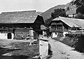
The region is rich in historical monuments and is especially known for the well-preserved rural architecture.

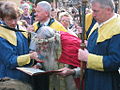
The Samson von Mauterndorf and his dwarfs

Prangstangen in Zederhaus
Palm donkey ride in Thomatal
Radenthein around 1920

Murtal Museum Railway


Filmography
- Green islands in the stone sea. Nockberge National Park , documentary, 45 min., Austria, 1997, by Klaus Feichtenberger, production: Science Vision.
literature
- Dieter Buck: The Nockberge. Nature and culture . Carinthia Verlag, Klagenfurt 1997, ISBN 3-85378-468-2 .
- Bettina Golob: The Nockberge . Natural science Association f. Carinthia, Klagenfurt 2003, ISBN 3-85328-031-5 .
- Ewald Neffe, Helmut Moik: Nockberge National Park . Styria, Graz 2002, ISBN 3-222-12958-4 .
Web links
- Website of the biosphere reserve (Carinthia, biosphaerenparknockberge.at)
- Website of the biosphere park (Salzburg, biosphaerenpark.com)
to the national park:
Individual evidence
- ↑ not yet recorded by Unesco, probably AUS07
- ↑ Thomatal – Schönfeld tourist office: beautiful - beautiful - Schönfeld
- ↑ Lungau holiday region . In: Salzburger Nachrichten : Salzburgwiki .
- ↑ a b c Around Obertauern, around 1 km² does not belong to the biosphere reserve. The Obertauern plant protection area largely covers the area towards Obertauern that is left out of the biosphere reserve, but extends a little further south and continues on the other side in the Pongau. The Lantschfeld, Oberes Zederhaustal, Oberes Murtal protected landscape area saves only about 50 hectares around the top of the pass.
- ↑ Reiter: Biosphere reserves as a research assignment from UNESCO - MAB. Opportunity for nature conservation, sustainable development, science. Presentation, University of Vienna, undated, slide National criteria for biosphere reserves ( pdf , accessed 7/2013, p. 9 there).
- ↑ Status ( Memento of the original from September 21, 2013 in the Internet Archive ) Info: The archive link was inserted automatically and has not yet been checked. Please check the original and archive link according to the instructions and then remove this notice. , biosphaerenparknockberge.at
- ^ Law on the establishment of national parks and biosphere parks (Carinthian National Park and Biosphere Park Act - K-NBG) . StF: LGBl. 55/1983 (idgF online, ris.bka ), amendment LGBl. No. 124/2012 , also: Government documents, explanations and text comparison to Zl. 01-VD-LG-1536 / 7-2012, both November 2012 (pdf, ktn.gv.at).
- ↑ Biosphere Park for the Lungau. In: NaturLand Salzburg. Issue 1, 2012, pp. 7–9 ( pdf ( memento of the original from September 21, 2013 in the Internet Archive ) Info: The archive link has been inserted automatically and has not yet been checked. Please check the original and archive link according to the instructions and then remove this notice . , salzburg.gv.at).
- ↑ see also Max AE Rossberg: New State Government: Sustainability and Biosphere Park ( Memento of the original from September 21, 2013 in the Internet Archive ) Info: The archive link was automatically inserted and not yet checked. Please check the original and archive link according to the instructions and then remove this notice. , on wir-sind-biosphaere.at, June 12, 2013, accessed August 10, 2013.
- ↑ cf. Lit. Information brochure Unesco Biosphere Park , map In order to be able to meet the requirements, a biosphere reserve is divided into three zones , and the following pages: core zone, maintenance zone, development zone (pdf p. 4 ff.)
- ↑ UNESCO Biosphere Park, on lungau.at
- ↑ § 6 Protection of the Alpine Region and § 8 Protection of Wetlands of the Carinthian Nature Conservation Act 2002 - K-NSG 2002 . LGBl. No. 79/2002; 9. Protection of habitats § 24 Salzburg Nature Conservation Act 1999 - NSchG. LGBl. No. 73/1999 (both as amended online, ris.bka ).
- ^ Manfred Scheuch: Austria - Province, Empire, Republic. A historical atlas. Verlag Das Beste, Vienna 1994, ISBN 3-87070-588-4 , Becoming Carinthia. P. 36 f. and Salzburg - archbishopric and imperial principality. P. 36 f.
-
↑ Lungau Eachtling . Entry no. 17 in the register of traditional foods of the Austrian Federal Ministry for Agriculture, Regions and Tourism .
Lungauer Eachtling at the Genuss Region Österreich association . - ↑ Lungau Tauern rye . Entry no. 100 in the register of traditional foods of the Austrian Federal Ministry for Agriculture, Regions and Tourism .
-
↑ Lungau Tauern rye . Entry no. 137 in the register of traditional foods of the Austrian Federal Ministry for Agriculture, Regions and Tourism .
Lungau Tauern rye at the Genuss Region Österreich association .