Wöllaner Nock
| Wöllaner Nock | ||
|---|---|---|
|
Wöllaner Nock (left, south view) as seen from Tassach (municipality of Afritz am See ) |
||
| height | 2145 m above sea level A. | |
| location | Carinthia , Austria | |
| Mountains | Nockberge , Gurktal Alps | |
| Dominance | 8.1 km → Moschelitzen | |
| Notch height | 1042 m ↓ southeast. Rottenstein | |
| Coordinates | 46 ° 46 '36 " N , 13 ° 49' 42" E | |
|
|
||
| rock | Quartzite | |
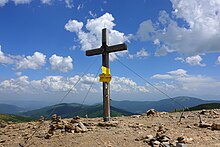
The Wöllaner Nock is a 2145 meter high peak in Carinthia and is located in the municipality of Arriach and is its highest point. It is part of the Nockberge and lies between the region valley in the south and the Bad Kleinkirchheim valley in the north. South of the summit is the village of Afritz am See , to the north is the village of Bad Kleinkirchheim.
In addition to several local hiking trails, the Salzsteigweg , an Austrian long-distance hiking trail from the Bohemian Forest to Arnoldstein , also leads over the summit of the Wöllaner Nock.
View of the Wöllaner Nock from the Oswaldiberg
Web links
Commons : Wöllaner Nock - Collection of images, videos and audio files


