Sankt Michael im Lungau
|
market community Sankt Michael im Lungau
|
||
|---|---|---|
| coat of arms | Austria map | |
|
|
||
| Basic data | ||
| Country: | Austria | |
| State : | Salzburg | |
| Political District : | Tamsweg | |
| License plate : | TA | |
| Surface: | 68.83 km² | |
| Coordinates : | 47 ° 6 ' N , 13 ° 38' E | |
| Height : | 1075 m above sea level A. | |
| Residents : | 3,512 (January 1, 2020) | |
| Population density : | 51 inhabitants per km² | |
| Postal code : | 5582 | |
| Area code : | 06477 | |
| Community code : | 5 05 09 | |
| NUTS region | AT321 | |
| UN / LOCODE | AT SEL | |
| Address of the municipal administration: |
Marktplatz 1 5582 Sankt Michael im Lungau |
|
| Website: | ||
| politics | ||
| Mayor : | Manfred Sampl ( ÖVP ) | |
|
Municipal Council : (2019) (21 members) |
||
| Location of Sankt Michael im Lungau in the Tamsweg district | ||
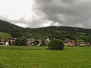
 View of St. Michael im Lungau |
||
| Source: Municipal data from Statistics Austria | ||
Sankt Michael im Lungau ( Lungau dialect : Michee ) is a market town located at 1075 meters above sea level in Lungau in Salzburg and with 3512 inhabitants (as of January 1, 2020) is the second largest municipality in the district.
geography
St. Michael is located in a valley at the foot of the Speiereck mountain . To the south is the Katschberg with the Katschbergpass and the Aineck mountain. The Mur River flows through the south of the market town . Until the end of January 1962 the community belonged to the judicial district of Sankt Michael im Lungau , since February 1, 1962 it has been part of the judicial district of Tamsweg .
climate
|
Average monthly temperatures and precipitation for St. Michael im Lungau
|
|||||||||||||||||||||||||||||||||||||||||||||||||||||||||||||||||||||||||||||||||||||||||||||||||||||||||||||||||||||||||||||||||||||||||||||||||||||||||||||||||||||||||
Community structure
The municipality includes the following five localities (population in brackets as of January 1, 2020):
- Court (265)
- Oberweißburg (310)
- Saint Martin (640)
- Sankt Michael im Lungau (2070)
- Unterweißburg (227)
The community consists of the cadastral communities Höf, Oberweissburg, St. Martin im Lungau, St. Michael im Lungau and Unterweissburg.
history
In the 5th century, the Romans were ousted from the Lungau by the great migration of peoples. The Slavs appeared, whose rule lasted about 200 years. The district of Stranach dates from this time.
In the 8th century, the Bavarians pushed back the Slavs.
The parish church was built in the 12th century.
In the 13th century the Archbishopric of Salzburg received the area of St. Michael.
In 1499 the Gasthaus Wastlwirt opened, which today is run as a 4-star hotel under this name by Rudi Baier in the fifth generation.
In the 18th century the guardianship court came to St. Michael, which belonged to Moosham Castle .
In 1822, the first glass blowing facility was built in St. Michael .
Partner communities
The partner community of St. Michael is Bad Leonfelden in Upper Austria .
coat of arms
The coat of arms of the community is: "In the red field on a green mountain (ground) a white clad Saint Michael with outspread wings, in the right the flaming sword, in the left holding a golden balance."
Population development

politics
The community council has a total of 21 members.
- With the municipal council and mayoral elections in Salzburg in 1974, the municipal council had the following distribution: 8 SPÖ, 7 ÖVP, and 4 FPÖ.
- With the out-of-tour municipal council election on September 21, 1975, the municipal council had the following distribution: 8 SPÖ,?
- With the municipal council and mayoral elections in Salzburg in 2004, the municipal council had the following distribution: 10 ÖVP, 8 SPÖ, and 3 FPÖ.
- With the municipal council and mayoral elections in Salzburg in 2009 , the municipal council had the following distribution: 12 ÖVP, 7 SPÖ, and 2 FPÖ.
- With the municipal council and mayoral elections in Salzburg in 2014 , the municipal council had the following distribution: 13 ÖVP, 6 SPÖ, and 2 FPÖ.
- With the municipal council and mayoral elections in Salzburg in 2019 , the municipal council has the following distribution: 13 ÖVP, 6 SPÖ, and 2 FPÖ.
- mayor
- 1974–1975 Richard Hochreiner (FPÖ)
- 1975 Gerhard Ortner (independent) (?)
- 1975–1979 Benedikt Schaiter (SPÖ)
- 1979–1982 Reinfried Pichler (FPÖ)
- 1982–1984 Franz Sampl (ÖVP)
- 1984–1990 Siegfried Gell (SPÖ)
- 1990–1994 Reinhold Wahlhütter (SPÖ)
- 1994–2009 Wolfgang Fanninger (ÖVP)
- since 2009 Manfred Sampl (ÖVP)
economy
Due to its geographical location, St. Michael is an important traffic junction - the St. Michael toll station is located between the Katschberg and Tauern tunnels . However, the main source of income is tourism. Winter tourism is not only very important in St. Michael, but in the entire Lungau. The Aineck-Katschberg and the local mountain Speiereck are only a few minutes away. The bus connections to the remaining ski areas are very well developed.
Culture and sights
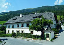
- Heihsgut
- Parish Church of St. Michael
- Filial church St. Martin
- Branch church Oberweißburg
- Branch and pilgrimage church of St. Giles
- The Samson custom is a very old custom in the Lungau in which a giant figure is carried around.
traffic
- Street: St. Michael is on the Tauern Autobahn (A10) and on the federal highways B96 and B99 . St. Michael is thus connected to Salzburg, Villach, Radstadt and Katschberg.
- Bus: St. Michael is only served by bus. There are trips to Salzburg, Tamsweg, Muhr, Katschberg and Radstadt.
societies
- St. Michael Volunteer Fire Brigade
- USK St. Michael
- Lungau hang-glider club
- FC Oberweißburg (District Champion 1996)
- FC St. Martin
- Le 'Fond - Business Development Association
- Traditional women
- Male choir of Oberweißburg
- Citizen Music St. Michael
- Rural youth St. Michael
Personalities
- Dagobert Peche (* 1887 in St. Michael; † 1923 in Vienna), applied arts
- Rudi Wilfer (* 1936), jazz musician, composer
- Hermann Neubauer (* 1988), Austrian State Rally Champion 2016
- Richard Hochreiner , FPÖ local politician and mayor of the municipality from 1974 to 1975
The dialect band Querschläger , which was founded in 1990 and has its roots in Lungau, is also known nationwide .
Web links
- 50509 - Sankt Michael im Lungau. Community data, Statistics Austria .
Individual evidence
- ↑ Statistics Austria: Population on January 1st, 2020 by locality (area status on January 1st, 2020) , ( CSV )
- ↑ Wastlwirt ( Memento of 27 November 2010 at the Internet Archive ); Retrieved April 4, 2011.
- ↑ Reinhold Wahlhütter . In: Salzburger Nachrichten : Salzburgwiki .
- ↑ Wolfgang Fanninger . In: Salzburger Nachrichten : Salzburgwiki .
- ↑ Klaus Heitzman: Information about St. Michael Samson on the Lungau customs portal. Lungau folk culture, accessed on June 17, 2020 .
- ↑ Homepage Hermann Neubauer Racing. Retrieved September 27, 2016 .


