Göriach
|
Göriach
|
||
|---|---|---|
| coat of arms | Austria map | |
|
|
||
| Basic data | ||
| Country: | Austria | |
| State : | Salzburg | |
| Political District : | Tamsweg | |
| License plate : | TA | |
| Surface: | 44.1 km² | |
| Coordinates : | 47 ° 10 ' N , 13 ° 46' E | |
| Height : | 1180 m above sea level A. | |
| Residents : | 344 (January 1, 2020) | |
| Postal code : | 5574 | |
| Area code : | 06483 | |
| Community code : | 5 05 01 | |
| NUTS region | AT321 | |
| Address of the municipal administration: |
Wassering 67 5574 Göriach |
|
| Website: | ||
| politics | ||
| Mayor : | Reinhard Radebner ( ÖVP ) | |
|
Municipal Council : ( 2019 ) (9 members) |
||
| Location of Göriach in the Tamsweg district | ||
| Source: Municipal data from Statistics Austria | ||
Göriach is one of the 15 communities in the Tamsweg district in Salzburg's Lungau in Austria , with 344 inhabitants (as of January 1, 2020).
geography
Göriach is about six kilometers northwest of the district capital Tamsweg and about 80 km southeast of the provincial capital Salzburg . The community area is formed by the Göriach Valley on the south side of the Schladminger Tauern and the Göriachbach stream flows through it.
The municipal area contains numerous peaks with a height of more than 2500 m above sea level. A. , of which the Hochgolling at 2862 m above sea level. A. is the highest. Other outstanding peaks are the Hocheck ( 2638 m above sea level ) and the Kasereck ( 2740 m above sea level ). The lowest point of the community is at approx. 1100 m above sea level. A. in the south, where the Göriachbach leaves the municipality.
Neighboring communities
Göriach borders in the north on the municipality of Schladming , which is located in the Liezen district of the federal state of Styria . Göriach is separated from it by the main Alpine ridge, which is formed here by the Schladminger Tauern . The neighboring community in the west is Mariapfarr , in the east Lessach . The boundary to both communities is formed by the natural boundary of the Göriach valley. In the south, where the valley opens to the Lungau Taurach , Göriach borders on Sankt Andrä im Lungau .
coat of arms
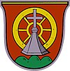
The coat of arms of the municipality is: "In a red shield on a green three-mountain a silver stand cross, behind it a six-spoke gold wagon wheel."
politics
The community council has a total of 9 members.
- With the municipal council and mayoral elections in Salzburg in 2004, the municipal council had the following distribution: 5 ÖVP, 3 SPÖ, and 1 FPÖ.
- With the municipal council and mayoral elections in Salzburg in 2009 , the municipal council had the following distribution: 6 ÖVP, 2 SPÖ, and 1 FPÖ.
- With the municipal council and mayoral elections in Salzburg in 2014 , the municipal council had the following distribution: 5 ÖVP, 3 SPÖ, and 1 FPÖ.
- With the municipal council and mayoral elections in Salzburg in 2019 , the municipal council has the following distribution: 5 ÖVP, 3 SPÖ, and 1 FPÖ.
- mayor
- until 1999 Anton Zehner (ÖVP)
- since 1999 Reinhard Radebner (ÖVP)
Partner communities
Asel in Harsum in Lower Saxony , Germany , is the partner municipality of Göriach.
Culture and sights
There are two cup stones in the village .
Web links
- 50501 - Göriach. Community data, Statistics Austria .
- Cup stones in Göriach
Individual evidence
- ^ Anton Zehner . In: Salzburger Nachrichten : Salzburgwiki .
- ↑ Reinhard Radebner . In: Salzburger Nachrichten : Salzburgwiki .
- ↑ Entry about the partner communities on the homepage of the community of Harsum.Retrieved on April 26, 2019, 1:40 am


