Asel (Harsum)
|
Asel
Harsum parish
|
||
|---|---|---|
| Coordinates: 52 ° 11 ′ 34 ″ N , 9 ° 58 ′ 9 ″ E | ||
| Height : | 87 m above sea level NHN | |
| Area : | 3.65 km² | |
| Residents : | 1171 (Jun. 30, 2019) | |
| Population density : | 321 inhabitants / km² | |
| Incorporation : | March 1, 1974 | |
| Postal code : | 31177 | |
| Area code : | 05127 | |
|
Location of Asel in Lower Saxony |
||
Asel is the third largest part of the municipality of Harsum and belongs to the Hildesheim district in Lower Saxony .
geography
The place is in the Hildesheimer Börde , about one kilometer south of Harsum between the Hildesheim-Lehrte railway line and the federal highway 494 . The Unsinnbach flows through the village. To the east of the village lies the Aseler Wald behind the B 494.
history
The town of Asel was first mentioned in a document in 1211 and is one of the oldest towns in Hildesheim Abbey . Later she belonged to the tax forest office. Because of the fertile soil, Asel was a farming village until the beginning of the 20th century. Today wheat and sugar beet are mainly grown. The place has grown significantly due to immigration.
Incorporations
For local government reform in Lower Saxony Asel was integrated into the community Harsum on 1 March 1974th
Population development
|
|

|
politics
Local council
The local council of Asel consists of 7 council members from the following parties:
- Free voters Asel (FWA) : 5 seats
- CDU : 1 seat
- SPD : 1 seat
(Status: local election September 11, 2016)
Local mayor
The local mayor is Ellen Krone (CDU). Your deputy is Leonie Voges (SPD).
coat of arms
Asel has had the heraldic shield with a golden spoked wheel on a red background, broken halfway to the right, since 1926.
The broken Martyriumsrad symbolizes one of the attributes of St. Catherine of Alexandria , the patron saint of the local church.
Culture and sights
Catholic Church of St. Catharina
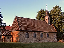
The oldest parts of the Catholic St. Catharine Church date from the 15th century. A small bell in the tower bears the name Katerina and the year 1498. This makes the church the oldest building in town. The historical organ (prospectus from the 16th century, pipework mostly from the 19th century) is one of the oldest church organs in Lower Saxony. Together with the altar, it comes from the Nikolaikirche in Hildesheim, which was dissolved in 1803 . The church patroness is St. Catherine of Alexandria . Since November 1, 2014, St. Catharina has been a branch church of the parish of St. Cäcilia , based in Harsum.
Paltrockmühle Asel

The Paltrockmühle was originally built in 1850 as a post mill near Schöppenstedt . In 1894 it was sold for 6,000 marks and rebuilt in Asel. At the same time it was converted into a Paltrockmühle. The mill was operated as a grain mill. After various changes of ownership, the mill was shut down in 1969 and became very dilapidated in the following years. Just one year after the establishment of the Asel e. V. in 1992 the mill was able to be restored to a functional condition.
Asel black earth profile
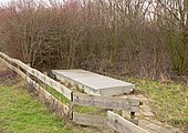
The Asel black earth profile is a soil profile that is located next to a freely accessible lawn at the Aseler Paltrockmühle. It is the only soil that is designated as a natural monument in Lower Saxony . The accessible show profile is covered by a metal construction and can be viewed on request in the Hildesheim district building. An information board explains the origins of black earth in the Börderegion. The soil around Asel is pseudogley - black earth , as the subsoil consists of impermeable and water-retaining clay . The soil profile is characteristic of the Hildesheimer Börde .
"1000-year-old" count oak
The oak stands on the Springberg on the B 494. Its real age is estimated to be around 500–600 years. The trunk circumference is 7.91 m, the crown has a diameter of about 30 m. The Swedish stone south of the oak bears the inscription “Dem Gott be gracious”. It is a grave stele that used to stand in the area between Asel and Drispenstedt .
Economy and Infrastructure
Asel is connected with the other localities of the municipality of Harsum, with Algermissen-Groß Lobke and with Hildesheim with the bus lines of the regional traffic Hildesheim . On the western outskirts of the village, the Lehrte – Hildesheim line passes without a S-Bahn stop. The federal highway 494 runs on the eastern edge of the village and about one kilometer south of the federal highway 7 with junction no. 61 (Hildesheim-Drispenstedt).
Personalities
People connected to the place
- John III von Asel (1380–1472), Bishop of Verden
- August Schaper (1840–1920), organ builder who mainly worked in the Hildesheim diocese, in 1884 he built the organ of the local St. Catharine Church
literature
- Aloys Köhler: From the history of the village of Asel 1211–2011. Druckhaus Köhler, Harsum 2010.
- Udo Stenger: Harsum, Asel and Klein Förste - pictures and stories from days gone by. Geiger publishing house, Horb a. N. 1984.
- Inge Wrage: Asel ... and the years passed, an old oak tells us. Ambaum-Verlag, Vöhl-Basdorf 2009, ISBN 978-3940616081 .
Web links
Individual evidence
- ↑ a b Lower Saxony State Administration Office (ed.): Community directory for Lower Saxony . Municipalities and municipality-free areas. Self-published, Hanover January 1, 1973, p. 30 , district of Hildesheim-Marienburg ( digitized [PDF; 21.3 MB ; accessed on February 21, 2020]).
- ↑ a b c d e f g Municipality of Harsum budget 2020 - population. (PDF; 5.3 MB) In: Website of the municipality of Harsum. June 30, 2019, p. 5 , accessed February 21, 2020 .
- ^ Federal Statistical Office (ed.): Historical municipality directory for the Federal Republic of Germany. Name, border and key number changes in municipalities, counties and administrative districts from May 27, 1970 to December 31, 1982 . W. Kohlhammer, Stuttgart / Mainz 1983, ISBN 3-17-003263-1 , p. 209 .
- ^ Ulrich Schubert: Community directory Germany 1900 - District Hildesheim. Information from December 1, 1910. In: gemeindeververzeichnis.de. January 5, 2020, accessed February 23, 2020 .
- ^ A b c Michael Rademacher: German administrative history from the unification of the empire in 1871 to the reunification in 1990. Hildesheim district ( see under: No. 4 ). (Online material for the dissertation, Osnabrück 2006).
- ↑ a b Statistisches Bundesamt Wiesbaden (ed.): Official municipality register for the Federal Republic of Germany - 1957 edition (population and territorial status September 25, 1956, for Saarland December 31, 1956) . W. Kohlhammer, Stuttgart 1958, p. 166 ( digitized version ).
- ^ Local councilor Asel. In: Website of the municipality of Harsum. Retrieved February 21, 2020 .
- ↑ Document on the dissolution of the Catholic parishes of St. Cäcilia, Harsum, St. Catharina, Harsum-Asel, St. Matthäus, Algermissen and on the establishment of the Catholic parish of St. Cäcilia, Harsum. In: Bischöfliches Generalvikariat (Hrsg.): Kirchlicher Anzeiger for the Diocese of Hildesheim . No. 8 . Druckhaus Köhler GmbH, Hildesheim November 3, 2014, p. 218-220 , col. 2 , p. 14 ( digitized version [PDF; 3.1 MB ; accessed on February 21, 2020]).
- ↑ Wulf pit Marion Gunreben: The black earth-profile Asel - Soil of the Year 2005: The Black Earth. (PDF; 226 kB) In: Website German Society for Geosciences. Archived from the original on December 30, 2016 ; accessed on February 21, 2020 .
- ↑ Grafeneiche in the directory of monumental oaks . Retrieved January 10, 2017
- ↑ a b localities of the municipality of Harsum. In: Website of the municipality of Harsum. Retrieved May 8, 2015 .


