Asel black earth profile
The Asel black earth profile is a geotope in Asel in the Hildesheim district . It is a soil profile that shows the soil type black earth on loess over clay from the Lower Cretaceous period in an accessible pit about 1.2 meters deep . The Asel black earth profile has been designated as a natural monument since 1990, making it the only soil profile in Lower Saxony that is protected by nature conservation law. It is located in the area of the Hildesheimer Börde , which is used intensively for agriculture and whose soils have the highest soil values in Germany.
location
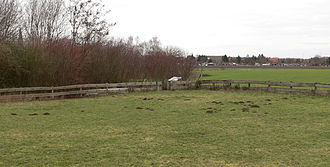
The black earth profile is located in the southwestern edge of the Hildesheimer Börde. It is located on the northwestern outskirts of Asel on a hill-like elevation near a listed Paltrock windmill . The profile lies on the edge of a former clay pit that was filled with rubble and soil and is no longer visible today.
description

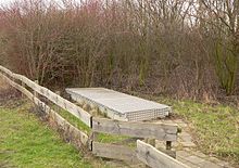
The Asel black earth profile is a walk-on show profile about 1.2 meters deep, which is freely accessible and can be viewed on request. It is on the edge of a group of bushes and a lawn. The profile can be accessed through a staircase leading down and has a lockable cover device made of metal for weather protection. An information board next to it explains the type of soil of the loess and how it was built during the Ice Age.
The forerunner of the show profile is an exposed ground outcrop around 70 meters away, also protected as a natural monument . It can be reached via a field and is therefore not suitable for larger groups of visitors. This exposed profile is not protected from the weather and has to be prepared again and again. The soil exposure shows the black earth in better form than the covered show profile.
Soil horizons
The black earth near Asel has developed under continental climatic conditions since the end of the last ice age around 18,000 years ago. A degradation to parabroun earth did not occur because the hydrological conditions caused a pseudo-gyration of the soil as a result of a water-retaining lower Cretaceous clay layer . Special characteristics of the soil around Asel are a mighty, 40 to 50 cm thick humus horizon as well as the carbonate-containing , ocher-colored loess up to a thickness of 1.6 to 2.5 meters . It contains Krotowinen ( burial tunnels filled with topsoil by soil diggers) and Lösskindel (limestone concretions). Underneath is the clay formed in the Lower Cretaceous about 110 million years ago.
Protection status and meaning
As early as the 1980s, the horticultural scientist Karl-Heinrich Hartge from the Institute for Soil Science at the University of Hanover pointed out the scientific importance of the soil profile. The University of Hanover suggested that it should be placed under protection, which was done on September 17, 1990 by the Hildesheim district. Since then, the excavation under the name "Black earth soil profile in the Asel clay pit" has been a natural monument within the meaning of the Lower Saxony Monument Protection Act . This is a specialty, as soil profiles in Germany have only rarely been designated as a monument.
In 2004 the black earth was declared the soil of the year 2005. Thereupon the district of Hildesheim decided to make the ground area, which has been protected since 1990, visible for teaching and research as well as for the public. A show profile was created as an open pit. An improvement was made in 2008, when the soil outcrop was enclosed with a concrete structure and a cover was provided for protection.
The special significance of the walkable show profile is that it is the only soil profile to show the original continental soil development in the bordering landscape from the time it was created. The soil profile is one of the best-known example objects for black earth soils in Western Europe . It is regularly visited by students from Lower Saxony universities as part of excursions.
Asel black earth lacquer profiles are located in the building of the Hildesheim district, at the Lower Saxony State Office for Mining, Energy and Geology in Hanover and in the international soil museum in Wageningen in the Netherlands. A lacquer profile of the Aseler Forest, one of the few German forests on black earth, is in the local history museum of the municipality of Harsum in nearby Borsum .
literature
- Wulf Grube, Marion Gunreben: The soil of the year 2005: Die Schwarzerde, the natural monument "Black earth soil profile in the clay pit Asel" , in: Bodenschutz 3/2005.
- Bördeboden is 18,000 years old , in: Hildesheimer Allgemeine Zeitung from December 15, 2006
- A unique hole , in: Hildesheimer Allgemeine Zeitung from November 25, 2008
- The Asel black earth profile is ready - an example object in Western Europe , in: Harsumer Rundschau from December 5, 2008
Web links
- Brief description of the Asel black earth profile with location map (PDF, 225 kB)
- Lacquer profile of the floor in the area of the Asel black earth profile with explanations
- Federal Institute for Geosciences and Raw Materials: Hildesheim Black Earth. Collection item of the month 11/05
Coordinates: 52 ° 12 ′ 1 ″ N , 9 ° 57 ′ 57 ″ E


