Laar (Zierenberg)
|
Laar
City of Zierenberg
Coordinates: 51 ° 24 ′ 25 ″ N , 9 ° 16 ′ 54 ″ E
|
|
|---|---|
| Height : | 210 m above sea level NHN |
| Area : | 10.52 km² |
| Residents : | 12 (2015) |
| Population density : | 1 inhabitant / km² |
| Incorporation : | 1st December 1970 |
| Postal code : | 34289 |
| Area code : | 05606 |
Laar is a district of Zierenberg in the north Hessian district of Kassel with fewer than 20 inhabitants.
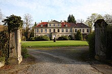
It consists of the few houses of the “ Gutshof Laar”, the “Old Mill” and the Laar Castle with its park.
geography
Laar is located in the northern part of the Habichtswald Nature Park, about 4.5 km north-northwest of the center of the town of Zierenberg. It is embedded in the valley lined by wooded mountains on the middle course of the southern Diemel tributary Warm and is located at about 210 m above sea level. NHN .
In addition to Zierenberg in the south, the next town is the Hohenborn district , around 1.5 km north , and the Rangen estate around 2 km south of Laar . About 2.5 km south-east is the Schartenberg castle ruins , about 2.5 km to the south-south-west are the Falkenberg castle ruins , about 2.5 km west-south-west is the Escheberg castle in Zierenberg- Escheberg and about 1.5 km west-north-west the Malsburg castle ruins (distances as the crow flies ).
history
Gut and Schloss Laar
The Laar estate, which is of cultural and historical importance due to the unity of its overall location, originally belonged to the judicial district of the Lords of Malsburg , in whose possession Laar was first mentioned in 1322. They sold the estate in two steps in 1688 and 1691 to the Hessian Landgrave Karl . In the following years the owners changed several times. Since 1902 the estate and castle have been owned by the descendants of Wilhelm von Starck . The farm buildings date from 1565 and 1599. The estate has a small cemetery that houses the graves of various lords and employees. The Laar Castle , to the south adjoins a park with a pond, was built on the western edge of the Gutsgeländes to 1790th
Old Mill
The lavishly restored " Old Mill ", which was built in 1599 as a water mill on the eastern edge of Laar on a 700 m long mill ditch of the Warme, has been generating electricity since its restoration in 1994 and houses a mill museum.
Ringwall Laar
About 350 m northeast of the mill and thus a little above Laar are the remains of the Laar ring wall , also known as the “Laarer Wand”, in the forest area of the “ Hagen Laar” , remnants of a spur castle built in the 9th century and destroyed in 938 .
Territorial reform
In the course of the regional reform in Hesse on December 1, 1970, the previously independent municipality of Laar was incorporated into the city of Zierenberg on a voluntary basis .
traffic
The state road 3211 runs directly to the west past Laar between Zierenberg and Hohenborn in a south-north direction . The Fulda-Diemel-Weg , a hiking trail between the rivers Fulda in the east and Diemel in the northwest , runs through Laar .
Web links
- Laar on the website of the city of Zierenberg.
- Laar, Kassel district. Historical local dictionary for Hessen. In: Landesgeschichtliches Informationssystem Hessen (LAGIS).
- Literature on Laar in the Hessian Bibliography
Individual evidence
- ^ Laar, Kassel district. Historical local dictionary for Hessen. (As of September 24, 2015). In: Landesgeschichtliches Informationssystem Hessen (LAGIS).
- ↑ Population of the city districts. ( Memento from February 29, 2016 in the Internet Archive ) In: Internet presence . City of Zierenberg. Accessed February 2016.
- ↑ Map services of the Federal Agency for Nature Conservation ( information )
- ↑ Water map service of the Hessian Ministry for the Environment, Climate Protection, Agriculture and Consumer Protection ( information )
- ↑ Incorporation of the Laar communities into the Zierenberg community in the Wolfhagen district on November 13, 1970 . In: The Hessian Minister of the Interior (ed.): State Gazette for the State of Hesse. 1970 No. 48 , p. 2254 , point 2252 ( online at the information system of the Hessian state parliament [PDF; 5,6 MB ]).
- ^ Federal Statistical Office (ed.): Historical municipality directory for the Federal Republic of Germany. Name, border and key number changes in municipalities, counties and administrative districts from May 27, 1970 to December 31, 1982 . W. Kohlhammer, Stuttgart / Mainz 1983, ISBN 3-17-003263-1 , p. 411 .
