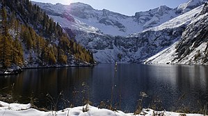
Lower Rotgüldensee
| Lower Rotgüldensee | |||||
|---|---|---|---|---|---|
| Lower Rotgüldensee with Großem Hafner | |||||
|
|||||
|
|
|||||
| Coordinates | 47 ° 5 '43 " N , 13 ° 24' 33" E | ||||
| Data on the structure | |||||
| Lock type: | Rockfall dam | ||||
| Construction time: | 1956-1957 and 1988-1991 | ||||
| Height above foundation level : | 45 m | ||||
| Building volume: | 346 000 m³ | ||||
| Crown length: | 273 m | ||||
| Crown width: | 5 m | ||||
| Base width: | 145 m | ||||
| Operator: | Salzburg AG | ||||
| Data on the reservoir | |||||
| Altitude (at congestion destination ) | 1733 m above sea level A. | ||||
| Water surface | 43 hectares | ||||
| Reservoir length | 1.3 km | ||||
| Reservoir width | 460 m | ||||
| Storage space | 14.9 hm³ | ||||
| Total storage space : | 15.6 hm³ | ||||
| Catchment area | 32.96 km² | ||||
The Lower Rotgüldensee is a reservoir with a storage target of 1733 m above sea level. A. , which is located within the Ankogel group in the Salzburg municipality of Muhr . In terms of energy, it is used as an annual storage facility and has a storage volume of 15 hm³ (20 GWh ).
dam
The former natural lake was initially dammed by an 18-meter-high stone embankment, completed in 1957, to form a storage lake with a net volume of 3 hm³ with a storage target of 1710.5 m . The relatively small catchment area of the reservoir of 9.8 km² was more than tripled from 1982 to 1984 by the incorporation of the Mur and Muritzen in a 6.1 km long free-flow gallery. In the years 1988 to 1991, the dam was then enlarged to its current dimensions of 45 meters in a second expansion stage, so that the Lower Rotgüldensee now takes up the entire valley. In the greening of the rocky embankment, new paths were explored as a pilot project by removing the vegetation in areas that were flooded by the enlarged lake and transplanting it onto the dam so that it now fits relatively harmoniously into the surroundings and the lake continues to look almost like one natural lake.
Energy use
The Lower Rotgüldensee is used as annual storage by the Hintermuhr power plant (104 MW ) of Salzburg AG . In 2008 the power plant was expanded into a pumped storage power plant and since then has also been using the Lower Rotgüldensee as an upper basin for pumped storage operation.
tourism
Directly at the western end of the dam is the Rotgüldenseehütte of the Austrian Alpine Club, which was built between 1992 and 1994 as part of the dam elevation .
literature
- Hermann Grengg (ed.): Statistics of the Austrian dams 1961 , Austrian Water Management Association, Vienna 1962, pp. 133–135.
- Franz Huber (Ed.): Dams in Austria , Austrian National Committee for Dams, Vienna 1991, pp. 175–178.
- Gerald Zenz (Ed.): Pumped Storage Hydropower in Austria , Austrian National Committee for Dams, Granz 2018, pp. 158–171.
Web links
Individual evidence
- ↑ Official website of the Rotgüldenseehütte , accessed on January 28, 2018

