
Spittal an der Drau district
| location | |
|---|---|
  |
|
| Basic data | |
| state | Carinthia |
| NUTS III region | AT-212 |
| Administrative headquarters | Spittal an der Drau |
| surface | 2764 km² |
| Residents | 75,868 (January 1, 2020) |
| Population density | 27 inhabitants / km² |
| License Plate | SP |
| website | www.bh-spittal.ktn.gv.at |
| map | |
  |
|
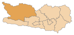
The Spittal an der Drau district is a political district in the Austrian state of Carinthia . The district administration is based in Spittal an der Drau .
geography
With an area of 2,763.99 km², the district is by far the largest district in Carinthia, after the Liezen district in Styria the second largest district in Austria and larger than the federal state of Vorarlberg . It is essentially congruent with the region known as Upper Carinthia in the north and west of the state. The region is shaped in the north and west by the mountains of the Hohe Tauern , whose numerous three-thousand-meter peaks are among the highest peaks in Austria, on the one hand, and the plain of the Upper Drautal as well as Mölltal , Maltatal and Liesertal on the other. Two of the four large lakes in Carinthia are located in the east and south of the district, Millstätter See and Weißensee .
The Spittal an der Drau district borders East Tyrol in the west and the state of Salzburg in the north .
Adjacent local authorities
| Zell am See | Sankt Johann im Pongau , Tamsweg | Murau |
| Lienz |
.svg)
|
Feldkirchen |
| Hermagor | Villach-Land |
Administrative division
The Spittal an der Drau district is divided into 33 communities, including three towns and ten market communities . The population figures are from January 1st, 2020.
|
Legend for the breakdown table
|

| local community | Slovenian | location | Ew | km² | Ew / km² | Judicial district | region | Type | Metadata |
|---|---|---|---|---|---|---|---|---|---|
Bad Kleinkirchheim
|

|
1,711 | 74.01 | 23 | Spittal an der Drau | local community |
According to code: 20601 |
||
Baldramsdorf
|

|
1,862 | 37.98 | 49 | Spittal an der Drau | local community |
Acc. To code: 20602 |
||
Berg im Drautal
|

|
1,268 | 54.24 | 23 | Spittal an der Drau | local community |
According to code: 20603 |
||
Dellach in the Drautal
|

|
1,590 | 76.09 | 21st | Spittal an der Drau | local community |
According to code: 20604 |
||
Flat flat
|

|
1,188 | 98.85 | 12 | Spittal an der Drau | local community |
Acc. To code: 20607 |
||
Gmünd in Carinthia
|
Sovodenj |

|
2,550 | 31.55 | 81 | Spittal an der Drau | urban community |
Acc. To code: 20608 |
|
Greifenburg
|

|
1,733 | 76.22 | 23 | Spittal an der Drau | market community |
Acc. To code: 20609 |
||
Großkirchheim
|

|
1.310 | 109.51 | 12 | Spittal an der Drau | local community |
According to code: 20605 |
||
Heiligenblut am Großglockner
|
Sveta Kri |

|
997 | 193.15 | 5.2 | Spittal an der Drau | local community |
Acc. To code: 20610 |
|
Irschen
|

|
1,966 | 33.43 | 59 | Spittal an der Drau | local community |
According to code: 20611 |
||
Kleblach-Lind
|

|
1,170 | 62.99 | 19th | Spittal an der Drau | local community |
According to code: 20613 |
||
Krems in Carinthia
|

|
1,661 | 207.48 | 8th | Spittal an der Drau | local community |
According to code: 20642 |
||
Lendorf
|

|
1,703 | 34.37 | 50 | Spittal an der Drau | local community |
Acc. To code: 20616 |
||
Lurnfeld
|
Lurnsko Polje |

|
2,679 | 33 | 81 | Spittal an der Drau | market community |
Acc. To identification: 20643 |
|
Mallnitz
|
Malnice |

|
762 | 111.73 | 6.8 | Spittal an der Drau | local community |
According to code: 20618 |
|
Malta
|

|
1.936 | 262.02 | 7.4 | Spittal an der Drau | local community |
According to code: 20619 |
||
Millstatt am See
|
Milje |

|
3,436 | 57.74 | 60 | Spittal an der Drau | market community |
Acc. To code: 20620 |
|
Mortschach
|

|
824 | 74.73 | 11 | Spittal an der Drau | local community |
According to code: 20622 |
||
Mühldorf
|
Mlinče |

|
1.007 | 24.42 | 41 | Spittal an der Drau | local community |
According to code: 20624 |
|
Oberdrauburg
|

|
1,188 | 69.92 | 17th | Spittal an der Drau | market community |
According to code: 20625 |
||
Obervellach
|
Zgornja Bela |

|
2,171 | 104.4 | 21st | Spittal an der Drau | market community |
According to code: 20627 |
|
Radenthein
|
Radenče |

|
5,782 | 89.3 | 65 | Spittal an der Drau | urban community |
Acc. To code: 20630 |
|
Rangersdorf
|

|
1,705 | 84.28 | 20th | Spittal an der Drau | local community |
According to code: 20631 |
||
Reisseck
|

|
2,101 | 139.71 | 15th | Spittal an der Drau | local community |
Acc. To identification: 20644 |
||
Rennweg on Katschberg
|

|
1,740 | 120.48 | 14th | Spittal an der Drau | market community |
According to code: 20632 |
||
Sachsenburg
|

|
1,322 | 42.59 | 31 | Spittal an der Drau | market community |
According to code: 20633 |
||
Seeboden on Lake Millstatt
|
Jezernica |

|
6,506 | 44.44 | 146 | Spittal an der Drau | market community |
According to code: 20634 |
|
Spittal an der Drau
|
Špital ob Dravi |

|
15,300 | 48.57 | 315 | Spittal an der Drau | urban community |
According to code: 20635 |
|
barn
|

|
1,524 | 96.46 | 16 | Spittal an der Drau | local community |
According to code: 20636 |
||
Steinfeld_COA.svg)
|

|
2,039 | 81.33 | 25th | Spittal an der Drau | market community |
According to code: 20637 |
||
Trebesing
|
Trebežinče |

|
1,162 | 73.79 | 16 | Spittal an der Drau | local community |
According to code: 20638 |
|
Weissensee
|

|
761 | 78.11 | 9.7 | Spittal an der Drau | local community |
According to code: 20639 |
||
Winklern
|

|
1,214 | 37.2 | 33 | Spittal an der Drau | market community |
According to code: 20640 |
Population development

The population is currently 76,248 inhabitants (2018). This means that since the high of 81,719 in 2001, more than 5,000 people, almost 7%, have been lost. Only 5 of the 33 municipalities were able to gain residents. First and foremost, Seeboden due to its proximity to the district town of Spittal, its location on Lake Millstatt and a nursing home . Winklern and Mühldorf also prove that a nursing home brings residents. There was still a slight increase in Millstatt and Baldramsdorf. The three municipalities with the greatest declines are Krems (over 20%) and Mallnitz and Mörtschach with just under 20%.

The population decline is expected to continue. One reason are students who do not return to their home community due to a lack of jobs. Other reasons are the low average income and the high unemployment rate :
 |
 |
A special feature is that a particularly large number of men from the Mölltal work in tunnel construction . In 2011 around 50 workers from the small community of Stall were involved in the construction of the Bosruck tunnel . Mölltalers have been working in tunnel construction across Europe for generations.
economy
The economy in the Spittal district has a clear focus on tourism , and the production sector is also above average, with a particularly strong construction industry .
Economic structure
The proportion of the population who works in agriculture and forestry corresponds to the Carinthian average. The production sector, where 30.1% of the population is active (2017), is more pronounced, while the service sector is less developed:
 |
 |
 |
In the Spittal / Drau district, the proportion of out- commuters is very high; almost a third of those in employment have their job in another district. In contrast, the proportion of inbound commuters is relatively low at 15%.
.jpg)
Agriculture and Forestry
In agriculture, the focus is on cattle farming , the basis of which is grassland management . Almost a third of the 150,000 hectares of grassland in Carinthia are in the Spittal district. The alpine management is particularly well developed . At 30,000 19,625 ha Almfutterflächen be LU 285 dairymen held (state 2017). As in all Carinthian districts, both the number of farms (to 1,636, a decrease of 1.7% compared to 2016) and the number of cattle kept (37,217 in 2017, minus 1.1% compared to 2016) are also decreasing in Spittal ).
In forestry, the sale of coniferous wood is the main source of income due to the altitude. In 2017, 442,606 solid cubic meters of wood were sold, of which over 99% (440,064 solid cubic meters) was softwood.

Industry / manufacturing, manufacturing of goods
The top 5 industrial companies in the Spittal an der Drau district are (as of 2017):
- RHI Magnesita in Radenthein: headquarters in Vienna, manufacture of refractory materials
- Strabag AG in Spittal / Drau: Head office in Vienna, international company in the construction industry
- Merck KG in Spittal: Headquarters in Darmstadt, pharmaceuticals, chemicals, biotech
- Noritec Holzindustrie GmbH in Sachsenburg: Part of Hasslacher Holding GmbH, wood processing
- Kärntnermilch reg.Gen.mbH in Spittal: milk and milk products
 |
While there is only a small number of large companies, the proportion of small and very small companies is high compared to other Carinthian districts.


tourism
Tourism is an important part of the economy in the Spittal / Drau district. Almost 4 million of the 13 million overnight stays in Carinthia were in Spittal (figures for the 2017 financial year). The distribution among the individual municipalities is quite different:
 |
The main attractions are the two large lakes Millstätter See and Weißensee, as well as the ski areas such as Bad Kleinkirchheim, Katschberg and Heiligenblut. The Hohe Tauern National Park and the Nockberge Biosphere Park are also largely located in the district. Despite this diversity, the development in tourism is below the average for Carinthia and Austria:

Development of overnight stays

Mining
Magnesite has been mined in Radenthein for more than 100 years . The mineral is used on site by RHI Magnesita for the production of refractory materials . In underground mining, 11 employees mine 67,995 t of magnesite (as of 2016).

Infrastructure / traffic
- Railway: The Drautalbahn , which runs from Maribor to Innichen , runs across the district from east to west . At Spittal an der Drau station, the Tauernbahn turns off, which runs via Mallnitz and the Tauern tunnel through the Gastein Valley to Schwarzach-St. Veit leads.
- Road: The Tauern Autobahn comes from Salzburg in the north through the Katschberg into the district, leads past Millstätter See and Spittal into the Drautal and further south to Villach . Important federal roads are the Drautalstraße , which connects Villach via Spittal with Lienz , the Mölltalstraße from Möllbrücke to Winklern, and the Großglockner Straße from Lienz via Winklern to Heiligenblut, where it continues as the Großglockner High Alpine Road through the Hohe Tauern National Park via the Hochtor (2,504 m) leads to Salzburg.
Web links
Individual evidence
- ↑ Statistics Austria - Population at the beginning of 2002–2020 by municipalities (area status 01/01/2020)
- ↑ Kleine Zeitung, The Spittal and Hermagor districts are shrinking. March 3, 2016, accessed January 7, 2019 .
- ↑ a b c d WIBIS, Carinthian Economic Development Fund - District profile 2017. Accessed on January 7, 2019 .
- ↑ Upper Austrian news, tunnel view. February 26, 2011, accessed January 7, 2019 .
- ↑ Südwestrundfunk, Stuttgart. May 28, 2016, accessed January 7, 2019 .
- ↑ WIBIS, Carinthian Economic Promotion Fund - District Profile 2017. Retrieved on January 7, 2019 .
- ^ Province of Carinthia, Agriculture Report 2017. Accessed on January 7, 2019 .
- ^ Province of Carinthia, Tourism. Retrieved January 7, 2019 .
- ^ ORF Carinthia, 100 years of RHI's Radenthein plant. April 11, 2012, accessed January 7, 2019 .
- ^ Federal Ministry of Sustainability and Tourism, Austrian Mining Handbook. Retrieved January 7, 2019 .
- ↑ Austria Tourism Portal, Großglockner High Alpine Road. Retrieved January 7, 2019 .
Coordinates: 46 ° 48 ' N , 13 ° 30' E