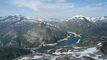
Crying beak
| Crying beak | ||
|---|---|---|
| height | 2754 m above sea level A. | |
| location | Carinthia / Salzburg border , Austria | |
| Mountains | Ankogel Group , Hohe Tauern | |
| Coordinates | 47 ° 5 '50 " N , 13 ° 21' 18" E | |
|
|
||
The Weinschnabel is a 2754 m above sea level. A. high mountain of the Hohe Tauern , on the border between Carinthia and the state of Salzburg .
Location and landscape

The summit (historically Schneeleitköpfl ) lies between the uppermost Murtal (Muhrtal) , Großarltal and Maltatal , above the Kölnbreinspeichersee , on the municipal boundaries of Großarl , Muhr and Malta .
The Weinschnabel is a western side summit of the Kaltwandspitze ( 2822 m above sea level ), the gap in between is about 2680 m . Then the ridge leads to the Hafner south-east. To the west the ridge falls to the Marchkarscharte ( 2384 m ), behind it lies the Brunnkogel at 2427 m above the Arlscharte , the transition from Grossarler Hüttschlag to Murwinkel . Northwestern The Kar is the Marchkar that over the valley of the only times available Schödersees to Großarlbach drained of at Schwarzach-St. Veit flows into the Pongauer Salzach . The Kölnbreinsee southwest accumulates the highest Malta (top barrage of Malta power stations ), which over the Lieser to Drava goes. To the north of Weinschnabel and Kaltwandspitze lies a high valley in which the Upper and Lower Schwarzsee are located. Here the ridge leads west of the lakes over the Muritzenscharte ( 2384 m ) to Marchkareck ( 2661 m ), and then on towards Murtörl . The closed kartal of the Schwarzseen drains in the block debris to the Karwassersee in the Muritzen east below, and the Muritzenbach to the uppermost Mur .
The mountain thus belongs to the main Alpine ridge and is the triple point of three fundamental river basin units in Austria , Danube to Jochenstein (DBJ), to which the Inn with the Salzach belongs, the Drau and the Mur - the latter in itself a tributary of the Drau , which is, however, counted independently in Austria . The Drau – Inn watershed leads in a westerly direction to the Dreiherrnspitze , the Salzburg-East Tyrolean-South Tyrolean triangle, and in a northerly direction to the Faulkogel , with the Inn-Drau-Enns triple point. The Jochenstein as a brand is right north on the Upper Austrian-Bavarian border in the Danube. The Drau – Mur watershed runs through the Hafner group to the Katschberg , and along the Carinthian-Styrian border to the mouth of the Murmur in the Slovenian-Hungarian-Croatian border triangle.
The summit is part of the Hohe Tauern National Park and the Lungau – Nockberge Biosphere Park .
geology
The summit is formed from the central alpine crystalline rocks of the Tauern window ("primary rock"). To the west of the summit are granites of the Hölltor-Rotgülden core, to the east of the old crystalline gneisses of the Hafner zone. These are paleozoic , 450 to 300 million year old remains of the Variscan basement of the Alps.
In the cirque of the Schwarzseen and on the southern flank, between Weinschnabel and Kaltwandspitze lies the debris from glacier remains .
Tours
Ascent is possible from all three sides of the valley. The Central Alpine Trail (Austrian long-distance hiking trail 02, here No. 502), stage Tappenkarseehütte - Murtörl or Sticklerhütte - Murursprung - Schmalzgrube (Albert bivouac on the Schmalzscharte ) to Kölbrein reservoir - Osnabrücker Hütte leads over the ridge on the Weinschnabel . The high trail passes the Weinschnabel to the south and a path leads to the summit. The tours are generally considered to be demanding, so there is a climbing area between the Schwarzseen.
Individual evidence
- ^ Franziszäischer Cadastre 1817–1861 (layer online at SAGIS)
- ↑ Christof Exner: Geology of the central Hafner group (Hohe Tauern). In: Jahrbuch der Geologische Bundes-Anstalt 125, Issue 1–2 (1982), esp. 2.7. Hölltor-Rotgülden-Kern , p. 93, full article p. 51–154, PDF on ZOBODAT there p. 43.
- ↑ Weinschnabel (from Hüttschlag). Tour dates on wanderdoerfer.at (accessed November 10, 2016).
- ↑ Weinschnabel (from Hüttschlag). Tour dates on bergfex.at (accessed November 10, 2016).
- ↑ From the Kölnbreinspeicher to the summit of the Weinschnabel. Tour dates on bergfex.at (accessed November 10, 2016).
- ↑ Stage 21A in Hans Führer: Tauern-Höhenweg: From the Seckauer Tauern to the Ahrntal in South Tyrol. Series Rother Wanderführer Special , Bergverlag Rother, 2016 ISBN 978-3-7633-4263-1 , p.168 f.
