Jochenstein
| Jochenstein | ||
|---|---|---|
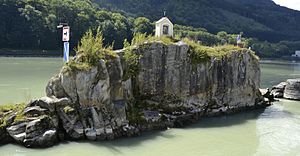
| The Jochenstein from the east | ||
| Waters | Danube | |
| Geographical location | 48 ° 30 '58.3 " N , 13 ° 42' 55.1" E | |
|
|
||
| length | 42 m | |
| width | 15 m | |
| surface | 0.045 ha | |
| Highest elevation | 290 m | |
| Sculpture of the mermaid Isa on the left (north) bank of the Danube, on the left at the edge of the picture the Jochenstein | ||
The Jochenstein is a small rock island on German territory near the German-Austrian border and rises about nine meters above the Danube . The rock is located in the upper reaches of the Danube at river kilometer 2202.72 and 78 meters from the left (northern) and 187 meters from the right river bank. It is part of the pile , a chain of quartz rocks in the Bavarian Forest, which runs along the Danube rim break through Lower Bavaria , and like the left (northern) Danube bank and the river to the left of the valley path , part of the Gottsdorf district the community of Untergriesbach .
The Jochenstein gives the place Jochenstein, a district ( village ) of the municipality Untergriesbach, the power plant Jochenstein , a floating pontoon crane and the ruins Altjochenstein and Neujochenstein the name. In addition, in the hydrography of Austria it forms the central border point between the two planning areas of the Danube up to and below Jochenstein . To the right or south of it on the opposite bank of the Danube is the Upper Austrian municipality of Engelhartszell with its cadastral municipality of Stadl.
Origin of name
The name Jochenstein probably goes back to the pagan custom of the St. John Minne, which was held as a libation on the winter and summer solstices . In the course of Christianization, it became the Blessing of St. John ( John the Baptist ), although it was customary until the 20th century to baptize new sailors at the Jochenstein. Today, a wayside shrine from the 18th century and a stone figure of the same age of St. John Nepomuk , who is the patron of the ship's people, stand on the rock.
There are several legends about the Jochenstein. For example the story that the devil wanted to flood the market town of Engelhartszell through a large wall in the Danube and dropped a devil's stone in the river; or the story of the mermaid Isa, who lives under the Jochenstein and attracts and beguiles the boatmen with her singing.
Importance as a border mark
The border between today's Bavaria and the Upper Austrian Mühlviertel from Jochenstein to the north was established in 1765 by a state treaty between the Principality of Passau and the Archduchy of Austria .
The so-called wet border between Bavaria and (Upper) Austria, which ends at the mouth of the Dandlbach about 940 meters below the Jochenstein, begins a good 20 kilometers upstream at Kräutelstein and follows the Danube valley path .
Danube up to and below Jochenstein
The Austrian geoscience separated at this rock the two major hydrographic planning areas Donau below Jochenstein (DUJ) comprising the entire intake region of the Danube itself, and Danube to Jochenstein (DBJ), whereby the catchment areas of the inns in Upper Austria and Tyrol and the Salzach are summarized . From Jochenstein the watershed runs through Sauwald and the Inn and Hausruckviertel hill country (where it marks the border between Innviertel and Hausruckviertel ) south to Hausruck and Kobernaußerwald , then (only roughly accompanying the Upper Austria -Salzburg border) through the Salzkammergut Mountains ( Kolomannsberg , Drachenwand , Hoher Zinken ) to the Gschütt pass , and over the Gosaukamm to the Hohe Dachstein , then it encompasses the Ennspongau of Salzburg via Roßbrand , Hochgründeck and Wagrainer Höhe , and ends at the Faulkogel in the Radstädter Tauern , where it crosses the watershed to the planning area Mur (MUR) meets. The watershed to the Weinschnabel ( Ankogel group ⊙ ) on the main Alpine ridge , to the Drau planning area, runs a little further over the Murtörl . The Mur flows (as Mura) into the Drau (Drava), and that also into the Danube / Black Sea (but far outside Austria), the other two large catchment areas, to the Rhine / Atlantic (RHI) and Elbe / Baltic Sea (ELB) stay small in Austria.
Jochenstein is the central measuring point because the Achleiten near Passau gauge , which measured the Danube when it entered Austria, has been in the area of influence of the Jochenstein reservoir since 1955, i.e. it only shows floods.
See also
literature
- Herbert Böck: The construction of the Jochenstein Danube power plant . Emphasis. In: Austrian water management . Born 8th Vienna 1956.
- Andreas Scheidleder, Günter Eisenkölb, Gabriela Vincze, Helga Lindinger, Franko Humer, Claudia Schramm, Elisabeth Stadler (employees), Federal Environment Agency: planning area Danube to Jochenstein . Ed .: Federal Ministry of Agriculture, Forestry, Environment and Water Management, Section VII / 1. ( doc , eionet.eu.int). Planning area Danube below Jochenstein . Catchment area Danube (incl. Elbe). In: Results report . Project inventory according to Articles 3 and 5 WFD, creation of maps, tables and texts; Work package location and boundaries of groundwater bodies (incl. WGEV measuring network). Part B. Vienna February 2005 ( doc , eionet.eu.int [accessed on October 9, 2010] short title WFD maps BMLFUW-UW.3.2.5 / 0008-VII / 2/2004).
Web links
Individual evidence
- ↑ Water Law 1959 - WRG 1959 StF: Federal Law Gazette No. 215/1959 (WV) Appendix F Catchment areas Appendix. 6 ( ris.bka , plan cannot be shown!)


