
Dragon wall
| Dragon wall | ||
|---|---|---|
 Dragon wall of Mondsee seen from |
||
| height | 1176 m above sea level A. | |
| location | Salzburg , on the border with Upper Austria ; Austria | |
| Dominance | 1.86 km → Treasure Wall | |
| Notch height | 165 m ↓ notch to the treasure wall | |
| Coordinates | 47 ° 48 '39 " N , 13 ° 21' 12" E | |
|
||
| rock | Wetterstein lime | |
| particularities | 700 m high north face | |

The Drachenwand is a rock face at 1176 m above sea level. A. Height in the Salzkammergut Mountains , a mountain group in the Northern Limestone Alps . Due to its attractive tourist location on the west bank of the Mondsee , it is a popular destination for hikes from St. Lorenz . Your forested southern side has only a slight slope to the north, however, making it an impressive, about 700 meters high, nearly vertical rock wall that the panorama of the northern Mondsee dominated .
geology
.jpg)
The Drachenwand was created by the tectonic forces of the Alpid mountain formation about 100 to 5 million years ago, when the rock masses of the Tyrolean blanket pushed from the south over the flysch zone , a rock formation that marks the transition to the Alpine foothills. The wall consists of extremely brittle Wetterstein limestone , which makes a mountaineering ascent tricky.
caves
At the foot of the wall hang a strong springs Karst source in the vicinity of nearly 25 meters wide portal of the Klaus Bach Cave (Cave register 1532/2, 47 ° 48 '45 " N , 13 ° 21' 23" O ). A narrow entrance is followed by more spacious cave parts and finally the so-called dragon hall , from whose lake the spring is fed. In the massive, post-glacial sediments in the entrance area, Latène Age and later cultural remains and pet bones were found.
North of it which is Nixloch to 47 ° 48 '53 " N , 13 ° 21' 18" O .
Directly below the ridge there is the Drachenloch , a rock window that turns the ridge into a narrow bridge.
Location and surroundings

The Drachenwand stretches for a good one kilometer from west to east and has its highest point at 1176 meters. The border between the Austrian federal states of Upper Austria in the north and Salzburg in the south runs along the ridge . Neighboring mountains in the west are the 1264 meter high Schatzwand and the 1328 meter high Schober , in the east the directly adjacent Drachenstein (1060 m, with summit cross ), and in the southeast the Almkogel with 1030 meters height. The next important place is St. Lorenz, a good one kilometer as the crow flies in a north-easterly direction on the west bank of the Mondsee.
Tourist development

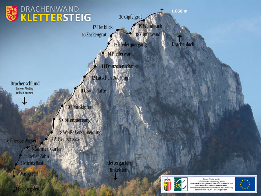
An alpine path leads to the Drachenwand, some of which is provided with rope insurance and ladders. Coming from the east, the village of Plomberg , a southern district of St. Lorenz, is the starting point for an ascent on this rocky path with a partial via ferrata character . In 2008, a via ferrata was built along the east ridge to the lower summit of the Drachenwand. This has a difficulty level of C and variant C / D and overcomes around 400 meters in altitude (including ascent around 560 meters in altitude). The alpine climbing is at the dragon wall due to the crumbling rock and the associated risk of rock falls tricky.
legend

The wall got its name after a legend. A dragon lived in a cave in the rock face and ravaged the area until a knight defeated the dragon. He is said to have built the watchtower to observe the kite, which the Wartfels ruins are reminiscent of today. There are several ways to explain the stone formation: One says that a pastor's cook secretly skimmed the cream from the milk and only served her employer with diluted milk, so the devil fetches it. According to another version, she disregards the ban on dancing during Lent. But since the cook complained loudly about her harsh punishment and began to moan and scream, the devil went off course, crashed through the middle of the mountain and tore a hole, the dragon hole , which can still be seen today.
Panoramas


Literature and map
- Wolfgang Heitzmann: Tour guide Salzkammergut, with totem mountains and Dachstein , Bruckmann Munich, 1998, ISBN 3-7654-3336-5
- Freytag & Berndt , hiking map 1: 50,000, sheet WK 282, Attersee-Traunsee-Höllengebirge-Mondsee-Wolfgangsee
- Via ferrata Topo
- Under the dragon wall , novel by Arno Geiger
Web links
Individual evidence
- ↑ Karl Mais, Gernot Rabeder: Speleology. For caving and exploring the caves . In: Upper Austrian Museum Association - Society for Regional Studies (Hrsg.): Yearbook of the Upper Austrian Museum Association . Year 128. Linz 1983, p. 393 ( PDF on ZOBODAT [accessed on February 19, 2010] from Trimmel 1972).
- ↑ Mondsee. ( ZIP ; 97 kB) Retrieved on February 19, 2010 (plan of the cave).
- ↑ Josef Pöttinger: The Upper Austrian folk tale. With pictures by KA Wilke . Scholle-Verlag, Vienna 1948, p. 118 .
- ↑ Ibid. P. 120.
- ↑ Josef Brettenthaler: The beautiful Mondseeland, A travel and memory booklet , Salzburg 1964, pp. 27-30.
- ^ W. Heitzmann: Tour Guide Salzkammergut, with Totem Gebirge and Dachstein , Munich, 1998, p. 24