
Hüttau (municipality of Hüttau)
| Hüttau ( village ) ( capital of the municipality ) | |||
|---|---|---|---|
|
|||
| Basic data | |||
| Pole. District , state | St. Johann im Pongau (JO), Salzburg | ||
| Judicial district | St. Johann im Pongau | ||
| Pole. local community | Hüttau ( KG Hüttau, Sonnberg , Sonnhalb ) | ||
| Locality | Hüttau ( Iglsbach , Sonnberg , Sonnhalb ) | ||
| Coordinates | 47 ° 24 '57 " N , 13 ° 18' 28" E | ||
| height | 697 m above sea level A. | ||
| Building status | 100 (approx., 2014) | ||
| Post Code | 5511 Huettau | ||
| Statistical identification | |||
| Counting district / district | Hüttau (50 412 000) | ||
| Allocation of place to place different information Source: STAT : place directory ; BEV : GEONAM ; SAGIS |
|||

Hüttau is a place in the Fritztal in the state of Salzburg as well as the capital , locality and cadastral municipality of the municipality of Hüttau in the St. Johann (Pongau) district .
geography
|
Hüttau locality cadastral community Hüttau
|
|
|---|---|
| Basic data | |
| Pole. District , state | St. Johann im Pongau , Salzburg |
| Pole. local community | Huettau |
| Coordinates | 47 ° 24 ′ 55 ″ N , 13 ° 18 ′ 10 ″ E |
| height | 7800 m above sea level A. |
| Residents of the village | 393 (January 1, 2020) |
| Building status | 95 (2001) |
| Area d. KG | 12.85 km² |
| Statistical identification | |
| Locality code | 14013 |
| Cadastral parish number | 55311 |
| KG includes O Hüttau and Iglsbach , together 598 inhabitants / 143 buildings. Source: STAT : Ortverzeichnis ; BEV : GEONAM ; SAGIS |
|
The place is located in the eastern Salzachpongau a good 45 kilometers southeast of Salzburg and 11 kilometers northeast of St. Johann .
The village of Hüttau is located on the Fritzbach at around 700 m above sea level. A. Höhe, 7 kilometers into the Fritztal east of Bischofshofen . At Hüttau , the Larzenbach flows from the north, from the southern foot of the Tennengebirge , between Plattenkopf ( 1147 m above sea level ) and Weyerberg ( 1455 m above sea level , inward of the valley), and - inward of the valley - Pichlbach, Sattelbach and Iglsbach from the Hochgründeck , the southern ones The summits above Hüttau are called Schroffkoppen ( 1542 m above sea level ) and Breitspitz ( 1804 m above sea level ). The place includes about 100 houses.
The village of Hüttau extends on the left side of the valley from Hüttau out of the valley, mainly the scattered houses Fritzerberg . Whether the place Hüttau itself belongs to the locality Hüttau, or to Sonnberg and Sonnhalb on the right side of the valley, there are different official information. The village comprises (according to Statistics Austria, with the place) almost 100 buildings with around 500 inhabitants. About 2 ⁄ 3 of these belong to the village itself, the others to the right of the Fritzbach have the addresses Sonnberg or Sonnhalb.
The town of Iglsbach also belongs to the cadastral community of Hüttau with 1285.4 hectares ; it extends over 6 km from Fritzbach southwards over Breitspitz and Hochgründeck peaks to Ginausattel .
|
Sonnhalb
(O & KG) |
Sonnberg (O and KG) | |
|
Alpfahrt (O)
Winkl (KG) (both in Bischofshofen ) |
.svg)
|
Bairau (O and KG) |
|
Buchberg (O and KG, district of Bischofshofen )
Ginau (KG, Gem. St. Johann iP )
|
Iglsbach (O) |
history
The fact that the important road over the Radstädter Tauern through the Pass Lueg to Iuvavum (Salzburg) ran here as early as Roman times (2nd – 5th centuries) is proven by several found milestones .
In the Middle Ages, copper mining in Iglsbach was important in the Fritztal, but mining on Larzenbach, a little north of the town, should have started as early as the 13th century. This Hüttau copper mine was first documented in 1549, trades from this time are the Perner and the Feuersenger. Throughout the early modern period, Hüttau was important as a mining site for the prince archbishopric .
Archbishop Gebhard had already handed over the Fritztal to the Salzburg spin-off Admont Abbey in 1074 . In 1325 the Hüttawe estate is mentioned in the Admonter Stiftsurbar (around 1390 Hüettawe , around 1427 Huttaw ). The name is already a mining name (' Au , in which is smelted ').
The first Leonhard chapel was built in 1450 - in 1451 the Capellam in honore Sancti Leonhardi in Fritza prope Hüttaw is documented. Today's Hüttau parish church was built between 1472 and 1492, the vicariate church in 1689 and the parish church in 1856 .
Mining declined sharply from the end of the 17th century, the deposits were exhausted, and the Mühlbach am Hochkönig copper mine became an overpowering competitor after the privatization of mining under Wolf Dietrich von Raitenau from 1600. A new attack in 1853 ( Barbara mine field ) was stopped again in 1869, and the sheet metal works (now at Sonnberg 3) were later demolished.
The Selzthal – Bischofshofen – Wörgl line, the Ennstal Railway, was opened on August 6, 1875. A larger station was built here for the handling of goods for copper mining.
From the 1960s, travel on the federal highway, the legendary guest worker route , became a problem . The Tauern Autobahn was opened here on June 30, 1979 (construction lot node Pongau - ASt Eben / Pongau ).
Infrastructure and sights
| Huettau | |
|---|---|
| Data | |
| Location in the network | Intermediate station |
| IBNR | 8100993 |
| opening | 1875 |
| Profile on ÖBB.at | No. 1481 |
| location | |
| Place / district | Hüttau-Sonnberg |
| state | Salzburg |
| Country | Austria |
| Coordinates | 47 ° 24 ′ 55 " N , 13 ° 19 ′ 12" E |
| Height ( SO ) | 722 m |
| Railway lines | |
| List of train stations in Austria | |
The Tauern Autobahn (A10) passes the town above ( Larzenbach valley crossing , 456 m), the next junction is Niedernfritz (Exit 56). Katschberg Straße (B99) runs through the village .
The Hüttau train station of the Ennstalbahn Bischofshofen - Selzthal is just outside the village and into the valley, in the Sonnberg cadastral community. Here hold regional -courses ÖBB ( Bischofshofen - Radstadt , partly on Schladming - St. Michael in Oberstmk. ), Which in the Salzburg transport association are involved (SIA). The journey time to Bischofshofen Bhf. Or Radstadt Bhf. Is a good 10 minutes, to Selzthal Bhf. A good 1½ hours.
| Previous station |
Ennstalbahn R |
Next station |
|---|---|---|
| Poham Hst | Hüttau Bhf | Niedernfritz-St. Martin Hst |
Buildings worth seeing are:
- Parish Church of St. Leonhard
- Larzenbach copper mine
- Trades house from 1594, today municipal office, museum and Gasthof zur Post

Hüttau, municipal office (trade union building from 1594)
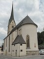
Hüttau, church


Web links
proof
- 50412 - Hüttau. Community data, Statistics Austria .
- Huettau . In: Salzburger Nachrichten : Salzburgwiki .
- Entry on Hüttau in the Austria Forum (in the AEIOU Austria Lexicon )
-
↑ a b c d The 2001 local directory of Statistics Austria gives the place Hüttau belonging to the locality Hüttau, according to current censuses 2011: Register census from October 31, 2011 (pdf, statistik.at) The state geographic information system SAGIS , however, indicates the town boundary on the left edge of the valley, so that the town falls entirely into the towns of Sonnberg and Sonnhalb - their boundary runs right through the parish church;
the address range Hüttau includes the place Hüttau to the left of the Fritzbach and the localities Fritzerberg, houses with the address Iglsbach mix in between them ; only the addresses Hüttau at the lowest Sattelbach belong to the village of Iglsbach ; the houses on the lower Igelsbach (sports field) belong to Bairau , so do the addresses;
the official local point of Sonnberg is near Hüttau, that of Hüttau below Fritzerberg;
the limit of Katastralgemeinden runs in the stream, so that the left-bank districts of Hüttau to KG Hüttau , the right side above the Larzenbachmündung to Sonnbergstuben , those below to Sonn half include - ^ Norbert Heger : The Roman milestones of Hüttau. In: Annual publication of the Salzburg Museum Carolino Augusteum 23/24 (1977/78).
- ↑ a b c d e history of the copper mine Hüttau , kupferzeche.at.
- ↑ 1325 . In: Salzburger Nachrichten: Salzburgwiki .
- ↑ Urbare, after Jacob Wichner: Benedictiner-Stift Admont in its relations to Erzstifte and Lande Salzburg. MGSLK 36 (1896), p. 166 resp. 167 (full article pp. 133-251).
- ↑ Adam Doppler: Excerpts from the original documents of the prince archbishop. Consistorial Archives in Salzburg (1441-1460). In: Communications from the Society for Salzburg Regional Studies (MGSLK) 14 (1874), p. 53.
- ↑ still recorded in the Franziszäischer Cadastre 1817–1861 (layer online at SAGIS)
- ↑ Autobahn and Schnellstraßen-Finanz-Aktiengesellschaft (Ed.): The autobahn network in Austria. 30 years of Asfinag . Self-published, Vienna / Absam January 2012, A 10 Tauern Autobahn , p. 84 ( pdf , asfinag.at). pdf ( Memento of the original from January 1, 2015 in the Internet Archive ) Info: The archive link was inserted automatically and has not yet been checked. Please check the original and archive link according to the instructions and then remove this notice.
- ↑ The train station itself is already in the locality of Bairau
- ↑ Station information Hüttau , ÖBB Scotty .
- ↑ Kupferzeche Hüttau (kupferzeche.at)
