
Myriameter stone
Myriameter stones are survey marks. A myriameter (from ancient Greek μυριάς myrias "ten thousand" - cf. myriad ) corresponds to 10,000 meters , i.e. 10 kilometers.
Myriameter stones on the Rhine

These historic milestones are placed every ten thousand meters to the right and left of the Rhine between Basel and Rotterdam .
history
The Central Commission for Rhine shipping ordered on 25 May 1864 in Amsterdam - after straightening of the Upper Rhine by Gottfried Tulla - the first time an overall survey of the river Rhine , which its beginning, the middle bridge to Basel km Rhine (now 166, 6) and should end at the mouth of the Rhine. Members were the states bordering the Rhine, Baden, Bavaria, France, Hesse, Nassau, the Netherlands and Prussia.
In 1867 the Central Commission decided to set marking stones, so-called myriameter stones, to mark the measurement results. The stones were made of Ibbenbüren sandstone with the approximate dimensions of 120 × 50 × 50 cm and ended in a flat, four-sided pyramid. All four sides were labeled. The side of the Rhine bears the number of the stone in Roman numerals. Below, the indication AP describes the height of the stone above the Amsterdam Peil ( Amsterdam level , corresponds to NN ), which is important for calculating the river gradient. On the land side, the distances from Basel and Rotterdam were given. Furthermore, the distances to the nearest national borders are sometimes noted on the mountain or valley side. Originally, stones painted in black and white were set every ten kilometers on both sides of the Rhine. From 1883 onwards they were replaced by national kilometers. They were temporarily valid until 1890. Today they are z. Some of them are still used as landmarks for land surveying.
labeling
The 23rd stone in Altlußheim on the right bank of the Rhine at km 396.57 serves as an example of typical inscription.
| photo | labeling | Explanation | |
|---|---|---|---|
| Waterside |
 |
XXIII. ---- 96.604 M + AP |
Stone no. 23 –––– 96.604 m above Amsterdam level |
| Land side |
 |
23.0000 M. from Basel. –––– 59.4450 m. To Rotterdam. |
23.0000 Myriameters (230,000 km) from the middle Rhine bridge in Basel (at km 166.6) –––– 59.4450 Myriameters (594.450 km) to (the port of) Rotterdam |
| Valley side |
 |
4.0072 sts to the border. |
4.0072 Myriameter (40.072 km) to the former border between the Grand Duchy of Baden and the Grand Duchy of Hesse (at km 436.6) |
| Mountain side |
 |
22.6520 sts from the state border. |
22.6520 myriameters (226.520 km) from the former border between the Grand Duchy of Baden and Switzerland (at km 170) |
Received stones
Many myriameter stones have now been removed, for example during construction work. Some of them have been restored by the local homeland associations and placed again in a prominent location. Today there are still over 70 myriameter stones between Basel and the border with the Netherlands. However, some are replicas. In the administrative district of Düsseldorf, in the administrative districts of Mainz-Bingen and Rhein-Hunsrück of the federal state of Rhineland-Palatinate and the city of Koblenz, they were included in the list of monuments.
The following list is not exhaustive.
| Stone no. | Rhine km | Rhine side | place | Comments (location) | photo |
|---|---|---|---|---|---|
| 2 (II) | 186.47 | left bank of the Rhine | Niffer (France) | On the Rhine island between the Rhine side canal and the Old Rhine |

|
| 185.86 | on the right bank of the Rhine | Bad Bellingen (Rheinweiler district) | Directly on the “Fischergrund” motorway car park; was only re-erected in October 2012 after it was removed during the construction of the motorway in the 1950s |

|
|
| 4 (IV) | 206.51 | left bank of the Rhine | Blodelsheim (France) | On the Rhine island between the Rhine side canal and the Old Rhine |

|
| 206.50 | on the right bank of the Rhine | Neuenburg am Rhein ( Grißheim district ) | On the east bank of the Old Rhine |

|
|
| 5 (V) | 216.49 | left bank of the Rhine | Geiswasser (France) | On the Rhine island between the Rhine side canal and the Old Rhine |

|
| 216.49 | on the right bank of the Rhine | Hartheim am Rhein |

|
||
| 7 (VII) | 236.43 | left bank of the Rhine | Marckolsheim (France) | On the Marckolsheimer Rheininsel; in the undergrowth a few meters behind the banks of the Rhine |

|
| 236.50 | on the right bank of the Rhine | Sasbach am Kaiserstuhl ( Jechtingen ) |
|
||
| 8 (VIII) | 246.55 | left bank of the Rhine | Artolsheim (France) |

|
|
| 9 (IX) | 256.5 | left bank of the Rhine | Rhinau (France) | On the island of Rhinau; lies on his side; the upper cuboid with the lettering is only partially preserved |
|
| 256.52 | on the right bank of the Rhine | Rheinau, municipality-free area | In the Taubergießen nature reserve |
|
|
| 10 (X) | 266.56 | on the right bank of the Rhine | Schwanau (district Nonnenweier ) |

|
|
| 12 (XII) | 286.5 | left bank of the Rhine | Strasbourg (France) | On the Rohrschollen Island |
|
| 286,500 | on the right bank of the Rhine | Kehl (district Goldscheuer ) |

|
||
| 13 (XIII) | 296.46 | on the right bank of the Rhine | Kehl (Rhine port) |
|
|
| 14 (XIV) | 306.46 | on the right bank of the Rhine | Rheinau |

|
|
| 15 (XV) | 316.45 | on the right bank of the Rhine | Lichtenau |
|
|
| 16 (XVI) | 326.52 | on the right bank of the Rhine | Rheinmünster (district Söllingen ) |
|
|
| 17 (XVII) | 336.50 | left bank of the Rhine | Beinheim (France) |

|
|
| 336.51 | on the right bank of the Rhine | Rastatt ( Wintersdorf district ) |

|
||
| 18 (XVIII) | 346.48 | left bank of the Rhine | in Mothern (France) |

|
|
| 19 (XIX) | 356.45 | left bank of the Rhine | Association municipality of Hagenbach |

|
|
| 356.45 | on the right bank of the Rhine | Karlsruhe ( Daxlanden district ) |

|
||
| 20 (XX) | 366.46 | on the right bank of the Rhine | Karlsruhe | Near the oil port |

|
| 21 (XXI) | 376.58 | left bank of the Rhine | Verbandsgemeinde Rülzheim (Hördt) |
_Landseite_2.JPG)
|
|
| 376.57 | on the right bank of the Rhine | Linkenheim-Hochstetten |

|
||
| 22 (XXII) | 386.45 | left bank of the Rhine | Germersheim | On the island of green |

|
| 386.45 | on the right bank of the Rhine | Philippsburg (Rheinsheim) |
|
||
| 23 (XXIII) | 396.57 | left bank of the Rhine | Speyer | Not on the banks of the Rhine, but approx. 200 m inland on a forest path that runs parallel to the Rhine |

|
| 396.57 | on the right bank of the Rhine | Altlussheim |
|
||
| 24 (XXIV) | 406,500 | left bank of the Rhine | Otterstadt |
|
|
| 406,500 | on the right bank of the Rhine | Ketch | On the Ketscher Rheininsel |

|
|
| 25 (XXV) | 416.7 | left bank of the Rhine | Altrip | Not on the banks of the Rhine, but on the banks of an old Rhine, right next to the Motorboat Club-Altrip |

|
| 26 (XXVI) | 424.75 | on the right bank of the Rhine | Mannheim (commercial port) | Between the Upper Rhine House (port authority) and Mannheim gauge ; was originally at km 426.5 |

|
| 27 (XXVII) | 437,000 | left bank of the Rhine | Bobenheim-Roxheim |

|
|
| 437,000 | on the right bank of the Rhine | Mannheim ( Sandhofen district ) | Exactly at the end of a so-called "short kilometer", where at km 436.66 (Baden-Hesse state border) the actual kilometering continues as km 437 |

|
|
| 28 (XXVIII) | 447,000 | on the right bank of the Rhine | Biblis (district of Nordheim ) | On the mulberry meadow |

|
| 29 (XXIX) | 457,000 | left bank of the Rhine | Worms-Ibersheim | Ibersheimer Wörth |

|
| 457,000 | on the right bank of the Rhine | Gross-Rohrheim |

|
||
| 30 (XXX) | 467,000 | left bank of the Rhine | Eich (Rheinhessen) |

|
|
| 467,000 | on the right bank of the Rhine | Biebesheim on the Rhine |

|
||
| 31 (XXXI) | 477,000 | on the right bank of the Rhine | Riedstadt ( Leeheim district ) |

|
|
| 32 (XXXII) | 487,000 | left bank of the Rhine | Verbandsgemeinde Bodenheim ( Nackenheim ) | Not on the banks of the Rhine, but two parallel streets away (Rheinstraße) |

|
| 487,000 | on the right bank of the Rhine | Trebur | Not on the banks of the Rhine, but about 150 m away on the eastern bank of the Ginsheim Old Rhine , at the top of the dike; Coordinate information in the coordinate reference system ETRS89 _ UTM32 : East: m 32,453,905 and North: 5,529,941 m 49 ° 55 '12.2 " N , 8 ° 21' 28.4" O |
|
|
| 34 (XXXIV) | 507,000 | left bank of the Rhine | Budenheim |

|
|
| 35 (XXXV) | 517,000 | left bank of the Rhine | Ingelheim am Rhein ( Frei-Weinheim ) |

|
|
| 516.998 | on the right bank of the Rhine | Oestrich-Winkel |

|
||
| 36 (XXXVI) | 527.03 | on the right bank of the Rhine | Rudesheim am Rhein | On the left bank of the Rhine at km 529.52 (former Hessian-Prussian state border), the kilometering is continued as km 530 (short kilometer). Due to the missing distance of 480 m, the next stone is not at km 537.0, but at km 537.480. |
|
| 37 (XXXVII) | 537,480 | on the right bank of the Rhine | Lorch |

|
|
| 40 (XL) | 567.44 | left bank of the Rhine | Boppard ( Bad Salzig district ) |

|
|
| 41 (XLI) | 577.48 | left bank of the Rhine | Verbandsgemeinde Rhein-Mosel ( Spay ) |
|
|
| 577.47 | on the right bank of the Rhine | Braubach |

|
||
| 42 (XLII) | 587.48 | left bank of the Rhine | Koblenz ( Stolzenfels district ) | Not on the banks of the Rhine, but on the next, parallel path |

|
| 43 (XLIII) | 597.48 | left bank of the Rhine | Koblenz ( Kesselheim district ) |

|
|
| 597.48 | on the right bank of the Rhine | Verbandsgemeinde Vallendar ( Niederwerth ) |

|
||
| 45 (XLV) | 617.46 | left bank of the Rhine | Then after |

|
|
| 47 (XLVII) | 637.48 | on the right bank of the Rhine | Uncle | Was restored in April 2014; north of the NATO ramp |

|
| 48 (XLVIII) | 647.48 | left bank of the Rhine | Bonn ( Bad Godesberg district ) | Was set up again by the Cologne Waterways and Shipping Authority on November 21, 2012. There are no inscriptions on it. The location is at the Bastei restaurant , Von-Sandt-Ufer 1. |

|
| 647.47 | on the right bank of the Rhine | Königswinter ( Niederdollendorf district ) | Not on the riverside path, but in the next parallel street “Rheinufer” opposite the playground of the Rheinpavillon restaurant. Was cleaned by the circle of Heimatfreunde Niederdollendorf and remeasured on November 29, 2012. The inscriptions read: waterside XLVIII / (illegible) M (eter) / __ / over A. (msterdam) P. (egel) , mountain side 117.180 KM / from the / Landes border , valley side 209,000 KM / to the / Landes border , landside 480,000 KM / from Basel / __ / 344,450 KM / to Rotterdam |

|
|
| 49 (XLIX) | 659.23 | left bank of the Rhine | Bonn (district Graurheindorf ) | Right on the riverside path. Inscriptions that can be rudimentarily recognized on the stone are illegible due to the weather. |

|
| 657.47 | on the right bank of the Rhine | Bonn (district Geislar ) | On the Kemper value, not on the Rhine, but 150 meters closest parallel thereto way to 50 ° 45 '39.5 " N , 7 ° 5' 49.3" O . The Siegufer is 40 m away. There are no inscriptions. |

|
|
| 50 (L) | 669.2 | on the right bank of the Rhine | Niederkassel ( Lülsdorf district ) | Right on the Walter Esser Bridge |

|
| 51 (LI) | 679.49 | left bank of the Rhine | Cologne (district white ) | Not on the banks of the Rhine, but on the next but one, parallel (concreted) path |

|
| 54 (LIV) | 713.82 | on the right bank of the Rhine | Monheim am Rhein | In Kapellenstrasse, opposite the Deusser-Haus (local history museum); originally stood in the old district of Blee |

|
| 55 (LV) | 717.47 | left bank of the Rhine | Dormagen (city district of Zons ) | 51 ° 7 '25.2 " N , 6 ° 51' 21.3" E |

|
| 715.72 | on the right bank of the Rhine | Monheim am Rhein ( Baumberg district ) | On the banks of the Rhine at the end of Klappertorstrasse; originally stood in the Baumberger Aue nature reserve |

|
|
| 56 (LVI) | 727.48 | left bank of the Rhine | Neuss ( Uedesheim district ) | On the banks of the Rhine near the confluence of the Silbersee |

|
| 727.47 | on the right bank of the Rhine | Düsseldorf ( Himmelgeist district ) | In the nature reserve Himmelgeister Rheinbogen; is not on the banks of the Rhine, but approx. 100 m inland |

|
|
| 58 (LVIII) | 747.48 | left bank of the Rhine | Düsseldorf ( Lörick district ) |

|
|
| 59 (LIX) | 757.48 | left bank of the Rhine | Meerbusch (Nierst district) | Not on the banks of the Rhine, but on the next, parallel path |
.JPG)
|
| 757.48 | on the right bank of the Rhine | Düsseldorf ( Wittlaer district ) | About 400 m north of Haus Werth (former towing station) |

|
|
| 60 (LX) | 767.48 | on the right bank of the Rhine | Duisburg ( Mündelheim ) | The upper cuboid on which the lettering was located is only preserved as a stump |

|
| 61 (LXI) | 780.2 | left bank of the Rhine | Duisburg ( Homberg district ) | Not on the banks of the Rhine, but on a path between the banks of the Rhine and Königstrasse, a few meters in front of the WSA Duisburg; was originally at km 777.48 |

|
| 62 (LXII) | 787.48 | left bank of the Rhine | Duisburg (district Baerl ) |

|
|
| 64 (LXIV) | 811.35 | left bank of the Rhine | Wesel ( Büderich district ) | Right at the Hotel Wacht am Rhein |

|
| 807.48 | on the right bank of the Rhine | Voerde (Niederrhein) ( Ork district ) | About 400 m south of the dike cross in Ork |

|
|
| 65 (LXV) | 824.4 | on the right bank of the Rhine | Wesel ( Bislich district ) | Not on the banks of the Rhine, but on Pastor-Kühnen-Platz in Bislich, right on the dike |

|
| 66 (LXVI) | 827.47 | on the right bank of the Rhine | Wesel ( Bislich district ) | In the Rheinaue Bislich-Vahnum nature reserve ; only the base remains |

|
| 67 (LXVII) | 837.29 | on the right bank of the Rhine | Rees | On the Rhine promenade; Due to its extensive changes, the Rees Myriameter stone has not been inventoried by the LVR office as a monument and has therefore not been entered in the list of monuments by the city of Rees. Information from Ms. Pieper (monument protection officer of the city of Rees) from October 5, 2011. |
|

Other myriameter stones
The Royal Saxon State Railways also used myriameter stones to station their railway lines. The copies on the Windbergbahn near Dresden , the narrow-gauge railway Wilkau-Haßlau-Carlsfeld and the Gera-Weischlitz line are still preserved today . The stone at kilometer 10,000 of the Elstertalbahn is still in use today, a more modern departmental sign has not been set up. The stone is located on the right side of the railway approx. 400 m south of the Wünschendorf (Elster) train station .
Furthermore, Myriameter stones have been preserved on roads, such as at Tochheim and at the Steutz exit in the Anhalt-Bitterfeld district. A Myriameter stone is located in the garden of the District Museum in Bitterfeld , Kirchplatz 3. In Pontebba there is a Myriameter stone on the former border between Italy and Austria .
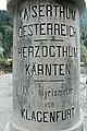
Myriameter stone on the old border between Austria and Italy in Pontebba

Myriameter stone at the Windbergbahn in Bannewitz
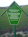
Corresponding display board for the Myriameter stone on the Windbergbahn in Bannewitz

Stein at km 10 of the Gera Süd – Weischlitz line

Myriameter stone at the exit of Steutz, direction Zerbst
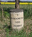
Myriameterstein after leaving Tochheim (Elbe) in the direction of Zerbst on the left.


_Myriameterstein.jpg)
See also
literature
- Friedrich Schmitt: Rhine survey and Myriameter stones . In: The bridge . No. 63, 1986, ZDB -ID 537491-1 , pp. 9-16.
- Friedrich Schmitt: Rhine survey and Myriameter stones . In: BDB-Landesnachrichten Rheinland-Pfalz, Saarland . Volume 3. 1993, ZDB -ID 1334017-7 , pp. 81-84.
- Bruno P. Kremer: Myriameter stones. (Almost) forgotten small monuments on the Rhine . In: Rheinische Heimatpflege . 48th Volume, No. 3, 2011, ISSN 0342-1805 , pp. 205-212.
Web links
- Reiner Letzner: Myriameter stones between Budenheim and Bacharach with various photos
- Myriameter stones near Monheim
- The Rhine river kilometrage (PDF; 342 kB)
- Gerd Michalek: Contemporary witnesses of Rhine shipping, Myriameter stones on the banks of the Rhine were an early measurement system . Deutschlandfunk
Individual evidence
- ^ Wilhelm Schneider, Government Surveyor, Eltville: The length measurement in the valley path of the Rhine (kilometrage). In: Wasser- und Schiffahrtsdirektion Duisburg (Hrsg.): The Rhine: expansion, traffic, administration. Rhein Verlagsgesellschaft, Duisburg 1951, pp. 303–308.
- ↑ Ulrike Weber (edit.): City of Koblenz. City districts (= General Directorate for Cultural Heritage Rhineland-Palatinate Directorate for Monument Preservation [Hrsg.]: Cultural monuments in Rhineland-Palatinate. Monument topography Federal Republic of Germany. Volume 3.3 ). Wernersche Verlagsgesellschaft, Worms 2013, ISBN 978-3-88462-345-9 , p. 329 .
- ↑ Informational directory of the cultural monuments in the Mainz-Bingen district . (PDF; 1.6 MB) General Directorate for Cultural Heritage Rhineland-Palatinate , Koblenz 2010.
- ↑ A stone goes on a journey . badische-zeitung.de, Bad Bellingen , October 6, 2012; Retrieved October 14, 2012
- ↑ Stein returns to the Rhine . badische-zeitung.de, Efringen-Kirchen , September 25, 2012; Retrieved October 14, 2012
- ↑ Much hype about myriameter stone . general-anzeiger-bonn.de
- ↑ Old stone is measured again . general-anzeiger-bonn.de
- ↑ The historical myriameter stone on the Rhine has been restored. (No longer available online.) City of Meerbusch, December 1, 2004, archived from the original on August 19, 2014 ; accessed on March 31, 2011 . Info: The archive link was inserted automatically and has not yet been checked. Please check the original and archive link according to the instructions and then remove this notice.
- ↑ Holger Drosdeck: narrow-gauge railway Wilkau-Haßlau-Carlsfeld - the illustrated book ; Foto & Verlag Jacobi, Fraureuth 2004, ISBN 3-937228-10-1 ; P.56
- ↑ monument directory Saxony-Anhalt, the district Bitterfeld, Volume 13, developed by Sabine Oszmer, Michael Imhof Verlag, Petersberg, ISBN 3-937251-53-7 , page 45