Ketchler Rheininsel
Coordinates: 49 ° 22 ′ 21 ″ N , 8 ° 30 ′ 48 ″ E
The Ketscher Rheininsel is a nature reserve near Ketsch , a municipality in the Rhein-Neckar district in Baden-Württemberg .
The area on the right side of the Rhine opposite Speyer with NSG no. 2.013 is 490.0 hectares and lies west of the core area of Ketsch. It has been under nature protection since April 11, 1950 (= date of the ordinance). The island was created by the straightening of the Rhine by Tulla and is part of the Rhine floodplain forest . The largest population of Vitis vinifera subsp. sylvestris in Germany. Also noteworthy is the occurrence of meadow valeriana pratensis , various orchids ( Cephalanthera damasonium , Neottia nidus-avis , Orchis ustulata and Orchis militaris ), oneberry , common viper tongue , edged leek and meadow elephant .

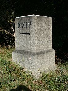
In the area at the Rhine kilometer 406.5 there is a measurement mark, a so-called myriameter stone .
Plants found on the Ketscher Rheininsel
See also
- List of nature reserves in the Rhein-Neckar district
- List of nature reserves in Baden-Württemberg
- List of German inland islands # Rhine
Web links
- 2.013 Ketchers Rhine Island - Profile
- Ketchler Rheininsel
- Rheininsel-Ketsch: https://www.rheininsel-ketsch.net/


