Wüstnächstenbach and Haferbuckel
|
Nature reserve "Wüstnächstenbach and Haferbuckel"
|
||
|
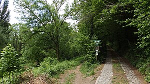
South entrance of the nature reserve |
||
| location | Weinheim in the Rhein-Neckar-Kreis in Baden-Wuerttemberg , Germany | |
| surface | 6.95 ha | |
| WDPA ID | 82951 | |
| Geographical location | 49 ° 34 ′ N , 8 ° 40 ′ E | |
|
|
||
| Setup date | August 17, 1937 | |
| administration | Karlsruhe Regional Council | |
The Wüstnächstenbach and Haferbuckel nature reserve is the oldest of the nature reserves in the city of Weinheim and the Rhine-Neckar district .
Characteristics
The area was designated as a nature reserve on August 17, 1937 by ordinance of the Baden Ministry of Culture and Education. The CDDA code is 82951 and corresponds to the WDPA ID .
location
The protected area is located east of the Weinheim district of Sulzbach and northwest of the village of Nachbarstenbach. It is located in the Bergstraße nature reserve and also belongs to the FFH area "Weschnitz, Bergstraße and Odenwald" near Weinheim.
See also
Individual evidence
- ↑ Leisure information about the nature reserve. Rhein-Neckar-Kreis, accessed on May 2, 2020 (German).
- ↑ Ordinance on the "Wüstnächstenbach und Haferbuckel" nature reserve in the Weinheim district. State Institute for the Environment Baden-Württemberg, accessed on May 2, 2020 (German).
- ↑ overview map FFH area 6417-341. State of Baden-Württemberg, accessed on May 2, 2020 (German).


