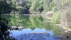
Frauweilerwiesen
|
"Frauweilerwiesen" nature reserve
|
||
| location | Wiesloch in the Rhein-Neckar-Kreis in Baden-Wuerttemberg , Germany | |
| surface | 12.3 ha | |
| Identifier | 2086 | |
| WDPA ID | 163144 | |
| Geographical location | 49 ° 17 ' N , 8 ° 41' E | |
|
|
||
| Setup date | 17th October 1985 | |
| administration | Karlsruhe Regional Council | |
The Frauweilerwiesen nature reserve is located in the area of the city of Wiesloch in the Rhein-Neckar district in Baden-Württemberg .
Characteristics
The protected area was created on October 17, 1985 by ordinance of the Karlsruhe Regional Council with the protected area number 2.086. This ordinance was published in the Law Gazette for Baden-Württemberg on November 29, 1985 and came into force thereafter. The CDDA code is 163144 and corresponds to the WDPA ID .
location
The nature reserve is located on the northwestern edge of the Kraichgau, directly southeast of the Frauenweiler district of Wiesloch . It is bounded in the south-east by the A 6 motorway and in the north-west by the B 3. It is a wetland area with two ponds created by clay mining and is part of the FFH area no. 6718.311 Nördlicher Kraichgau . The area is located in the natural area 125-Kraichgau within the main natural unit 12- Neckar- and Tauber-Gäuplatten .
Protection purpose
According to the Protected Area Ordinance, the main protection purpose is the preservation of the last wet meadows and a wetland area created after the abandoned clay mining as a habitat for native plants and animals, in particular as a spawning or breeding ground for endangered fish, amphibian, reptile, bird and small mammal species.
See also
literature
- District Office for Nature Conservation and Landscape Management Karlsruhe (Ed.): The nature reserves in the administrative district of Karlsruhe . Thorbecke, Stuttgart 2000, ISBN 3-7995-5172-7
Individual evidence
Web links
- Profile of the nature reserve in the LUBW's list of protected areas


