Ginsheim Old Rhine
| Ginsheim Old Rhine | ||
|
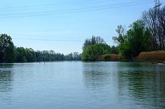
The Old Rhine above Ginsheim |
||
| Data | ||
| Water code | DE : 2398, DE : 23988 | |
| River system | Rhine | |
| origin | Junction from the Rhine 49 ° 55 ′ 11 ″ N , 8 ° 21 ′ 22 ″ E |
|
| muzzle | in the Rhine coordinates: 49 ° 58 ′ 11 ″ N , 8 ° 19 ′ 49 ″ E 49 ° 58 ′ 11 ″ N , 8 ° 19 ′ 49 ″ E
|
|
| length | 6.3 km | |
| Catchment area | 548.79 km² | |
The Ginsheimer Altrhein , known in earlier times as the Langenau Rhine or the Little Rhine , is a 6.3 kilometer long branch of the Old Rhine on the right bank of the Rhine between the Nackenheimer Schwelle and the Main estuary . It is part of an FFH and bird protection area , another FFH area borders on the arm of the Rhine.
It branches at Rhine kilometer 487.0 against the Nackenheimer Islands Kisselwörth and Sändchen on the Rhine. The access itself is closed by a tail unit, which flows around from the lower end so that the water reaches the actual separating dam to the Rhine from the north. Originally, two pipes were laid through the dam, which also serves as an access road to Langenau, to channel water from the Rhine into the Old Rhine arm. Later, a culvert was built higher up to supply the Old Rhine arm with a larger amount of water. The slope at the dam is about 50 cm.
For the first two kilometers, the Old Rhine meanders in several wide arcs parallel to the Rhine until it moves away from it in a long straight and after five kilometers reaches the town of Ginsheim . From here it goes straight back to the main stream, which is reached half a kilometer above the Weisenauer bridge at Rhine kilometer 492.9. The Ginsheimer Altrhein is a nature reserve above the village of Ginsheim . In addition, the Old Rhine is also closed to all other watercraft for two months from April 15th due to the breeding season .
In the first two kilometers in particular, the Old Rhine tends to silt up and when the tide is low, it dries up to the main channel. From Ginsheim, on the other hand, it is artificially deepened and can be navigated by motorboats even when the water is low, and on the lower section between the pier in Ginsheim and the Rhine also for larger ships. This is rarely used by passenger ships that head for the Ginsheim pier.
In Ginsheim there is a canoe club and a motorboat marina on the Old Rhine. In addition, the Johanna cable ferry in the center of the village connects the mainland with the Nonnenaue.
There are two small islands in the Ginsheimer Altrhein ; the upper one is directly below the dam, the second about two kilometers further downstream. The current is low for the first kilometer, but it is hardly noticeable further down. The bank on the island side in particular is close to nature and overgrown with extensive willow stands and partly reed belts. The landside bank is partially fortified with armourstones in the middle area.
In the Middle Ages, the Bohemian Castle of Astheim was located in the middle of the east bank . Up to 21 ship mills worked in the Ginsheim area at weddings from the Middle Ages to the 19th century .
In the upper third, several drainage ditches from the Hessian Ried flowed into the Old Rhine, which can still be seen today from the ruins of a pumping station one kilometer below the dam. Today these trenches are being led into the Old Rhine at a new pumping station at the level of the second island. Right at the beginning of the development of Ginsheim, the Schwarzbach flows as the only major tributary into the Ginsheimer Altrhein. Since this drains the entire area from south of Frankfurt and Offenbach to Darmstadt, the Old Rhine has a relatively large catchment area and takes over its water code number below the mouth of the Schwarzbach.
The island formed by the Old Rhine and the main stream bears the name Langenau in the southern part and Nonnenaue in the northern part .
Many fish species have made their home in the arm of the Rhine, including a. European eel , perch , bream , chub , pike , crucian carp , carp , asp , roach , rudd , tench , catfish and pikeperch .
Web links
literature
- Peter Laun: Memorandum on the Old Rhine near Ginsheim
Individual evidence
- ↑ a b Water map service of the Hessian Ministry for the Environment, Climate Protection, Agriculture and Consumer Protection ( information )
- ↑ Management plan (action plan) for the FFH / VS area “Main estuary / Ginsheimer Altrhein” with sub-area of the FFH area “Riedloch von Trebur with adjoining area” of January 29, 2012 (PDF file, 9.1 MB); accessed on August 3, 2018
- ↑ Bird sanctuary 6016-401: Main estuary and Ginsheimer Altrhein on www.rpda.de
- ↑ HE-WFD
- ↑ flow information of the Hessian canoe Association ; accessed on August 3, 2018
- ↑ Shipping Ordinance: Ginsheimer Altrhein Ordinance regulating shipping on the Ginsheimer Altrhein ; accessed on August 3, 2018
- ↑ Boathouse Haupt ; accessed on August 3, 2018
- ↑ Christoph Ohlig: DWhG - Ten Years of Water History Research and Reports (Volume 20 / Part 2), DWhB, BoD Norderstedt, ISBN 978-3-8448-1160-5 . P. 588
- ↑ Water profile Ginsheimer Altrhein on www.anglermap.de ; accessed on August 3, 2018

