
Graurheindorf
|
Graurheindorf
Federal city of Bonn
Coordinates: 50 ° 45 ′ 45 ″ N , 7 ° 4 ′ 40 ″ E
|
|
|---|---|
| Height : | 52 m above sea level NHN |
| Residents : | 3478 (Dec. 31, 2018) |
| Postal code : | 53117 |
| Area code : | 0228 |
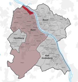  Location of the Graurheindorf district in the Bonn district
|
|
Graurheindorf is a district of the federal city of Bonn in the city district of the same name . It is located in the north of Bonn and is bounded by the Rhine River and the districts of Bonn-Castell and Auerberg . Graurheindorf has been part of the city of Bonn since 1908.
history

Rindorp was first mentioned in 1131, when the church and castle (at that time still as a manor house) were first mentioned in a document. A monastery of the Cistercian women was founded here around 1230 . The Graurheindorfer Castle was destroyed in 1689 and rebuilt in its present form in 1755 as a mansion. The builder is believed to be Michael Leveilly , who also created Bonn's town hall . The Estermannstraße follows the course of the Roman Heerstraße, the buildings along this street are one of the rare surviving examples of a Franconian street village.
The parish church of St. Margaret was built on the site of a Roman country house. The Bonn city toll was levied at the confluence of the Rheindorfer Bach . In 1809 the entire Rhine village was incorporated into the city of Bonn under French rule. It was given the epithet "gray" based on the gray costume of the Cistercian women to distinguish it from the nearby Black Rhine village on the right bank of the Rhine . From there on, Rheindorf became the Bonn-Graurheindorf district.
From the middle of the 19th century, the social life in Graurheindorf took shape: In 1848 the St. Sebastianus Schützenbruderschaft was founded, in 1872 the men's choir. At the turn of the century in 1900, the Rheindorf volunteer fire brigade was formed, and it still bears this name today. Bonn's Rheinhafen was built in Graurheindorf in the 1920s, and the Auermühle , which is now used as an office building, also dates from this time .
Graurheindorf has around 3,000 inhabitants today. Although the district was incorporated into the city of Bonn 200 years ago, the simple, almost rural street scene has been preserved.
Infrastructure


South of the port on the edge of a residential area is the Salierweg sewage treatment plant , which was built in 1934 and fundamentally expanded and redesigned in 1958 and from 1977 to 1985 and again from 1989. It is responsible for the waste water disposal of 22 districts of the city of Bonn and partly of the municipality of Alfter as well as for the incineration of the sewage sludge from the other sewage treatment plants in the city and from Königswinter . As a connection between building construction and landscape architecture , the septic tank with a height of around 20 m was given a green hood, which is distinctive in the cityscape, through earthfills in the form of a cone-shaped casing. The chimney of the incinerator is around 70 meters high.
Sports
Football is also played in Graurheindorf. TV Rheindorf has been playing there since 1911. In 2018, what was then Ascheplatz was converted into an artificial turf pitch.
See also
Web links
Individual evidence
- ↑ Population in Bonn by districts (according to the main statute) on December 31 , 2018 , Federal City of Bonn - Statistics Office, February 2019
- ^ Andreas Denk , Ingeborg Flagge : Architekturführer Bonn . Dietrich Reimer Verlag, Berlin 1997, ISBN 3-496-01150-5 , p. 77.
- ^ Ingeborg Flagge: Architecture in Bonn after 1945: Buildings in the federal capital and its surroundings . Verlag Ludwig Röhrscheid, Bonn 1984, ISBN 3-7928-0479-4 , p. 170.
- ↑ a b c Salierweg sewage treatment plant: chimney, glass roof and burner must be replaced , press release from the city of Bonn, August 28, 2012
- ↑ Bonn sewage treatment plant , City of Bonn
- ↑ City of Bonn renovates largest sewage treatment plant for 920,000 euros , General-Anzeiger , August 29, 2012
- ↑ Edgar Haupt (Ed.): 5x11. From the architectural in the landscape. RMP Stephan Lenzen Landscape Architects , Pellens Verlag, Bonn 2006, ISBN 3-9810534-2-7 , p. 132 f.

City districts: Bad Godesberg | Bulge | Bonn | Hardtberg
Districts: Alt-Godesberg | Auerberg | Beuel center | Beuel-Ost | Bonn-Castell | Bonn Center | Brüser Berg | Buschdorf | Dottendorf | Dransdorf | Duisdorf | Endeich | Friesdorf | Geislar | Godesberg-North | Godesberg villa district | Graurheindorf | Gronau | Hard height | Heiderhof | Hochkreuz | Wood | Holtorf | Holzlar | Ippendorf | Kessenich | Küdinghoven | Lannesdorf | Lengsdorf | Lessenich / Meßdorf | Limperic | Flour | Muffendorf | Nordstadt | Oberkassel | Pennenfeld | Plittersdorf | Poppelsdorf | Pützchen / Bechlinghoven | Ramersdorf | Röttgen | Rüngsdorf | Schwarzrheindorf / Vilich-Rheindorf | Schweinheim | Südstadt | Fir bush | Ückesdorf | Venusberg | Vilich | Vilich-Müldorf | West town