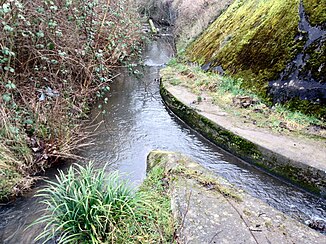
Hardtbach (Rhine)
|
Hardtbach The sections in the lower reaches are called:
|
||
|
Mouth of the Endeicher Bach from the right into the Dransdorfer Bach on Siemensstraße (Bonn) |
||
| Data | ||
| Water code | DE : 27198 | |
| location | North Rhine-Westphalia , Germany | |
| River system | Rhine | |
| Drain over | Rhine → North Sea | |
| source | Southwest of Volmershoven 50 ° 40 ′ 19 ″ N , 7 ° 0 ′ 30 ″ E |
|
| Source height | 159 m above sea level NHN | |
| muzzle | Near Bonn - Graurheindorf in the Rhine Coordinates: 50 ° 45 ′ 45 ″ N , 7 ° 4 ′ 56 ″ E 50 ° 45 ′ 45 ″ N , 7 ° 4 ′ 56 ″ E |
|
| Mouth height | 50 m above sea level NHN | |
| Height difference | 109 m | |
| Bottom slope | 7.3 ‰ | |
| length | 14.9 km | |
| Catchment area | 71.189 km² | |
| Big cities | Bonn | |
| Communities | Alfter | |
The Hardtbach is a 14.9 km long orographic left tributary of the Rhine in North Rhine-Westphalia , Germany .
geography
The Hardtbach rises southwest of Volmershoven on the municipality border between Alfter and Meckenheim at an altitude of 159 m above sea level. NHN . From here the stream flows to the northeast and after a short run reaches the southern outskirts of Volmershoven. This is where the stream coming from Kottenforst station flows, which is indicated by the water stationing map of North Rhine-Westphalia, contrary to its own topographic maps, as a source river with a total length of 17.1 km.
The Hardtbach Witterschlick flows further north , where the stream is canalised in the area of the Deutsche Steinzeug Cremer & Breuer works . His further path leads him via Nettekoven and Oedekoven to the Bonn district of Lessenich / Meßdorf . From the city limits the brook is called Der Alte Bach . Here the canalised Heilsbach flows from the right . A few kilometers further, the stream reaches Dransdorf . From here on the brook is called Dransdorfer Bach . In Dransdorf the also canalised Endeicher Bach flows into it from the right . After the stream has crossed under the Federal Motorway 565 , it changes its name for the last time and is called from here to the mouth of the Rheindorfer Bach or Mondorfer Bach . Before that, the stream passes the Bonn-Castell district before it reaches Graurheindorf at 50 m above sea level. NHN flows into the Rhine on the left .
On its 14.9 km long path, the stream experiences a gradient of 109 meters, which corresponds to a mean bed gradient of 7.3 ‰.
Catchment area and tributaries
The catchment area of the Hardtbach is 71.189 km² and drains over the Rhine into the North Sea.
|
Stat. in km |
Surname | GKZ | location | Length in km |
EZG in km² |
|---|---|---|---|---|---|
| 14.2 | Hünnesbach | 27198-? | right | 0.9 | ? |
| 13.4 | Tonbach | 27198-112 | Left | 1.016 | ? |
| 12.0 | Hitelbach | 27198-12 | right | 1.385 | 2.009 |
| 10.8 | NN | 27198-132 | Left | 1.459 | ? |
| 10.0 | Katzenlochbach | 27198-14 | Left | 2.863 | 4,722 |
| 9.8 | Markeskaulenbach | 27198-16 | Left | 2,698 | 2.897 |
| 7.5 | Heilsbach | 27198-19 | right | 1.79 | 0.6 |
| 4.3 | Endeicher Bach | 27198-2 | right | 11,563 | 28.298 |
Notes on the table
- ↑ waters code , the official in Germany watercourses code with inserted for readability separator behind the prefix uniform for all common outfall Hardt Bach stands.
- ↑ Not in the water directory of the State Office for Nature, Environment and Consumer Protection NRW 2010 (XLS; 4.67 MB) ( notes ). In older maps the upper reaches of the Hardtbach. Length as measured using the German base map 1: 5000.
- ↑ Not in the water directory of the State Office for Nature, Environment and Consumer Protection NRW 2010 (XLS; 4.67 MB) ( notes ).
- ↑ The most important tributary is the Endeicher Bach , even if it is not listed as an inflow in the water register of the State Office for Nature, Environment and Consumer Protection NRW 2010 (XLS; 4.67 MB) ( notes ).
Web links
Dransdorfer Bach on the millipede .
Individual evidence
- ↑ a b c d Water directory of the State Office for Nature, Environment and Consumer Protection NRW 2010 (XLS; 4.67 MB) ( Notes )
- ↑ a b German basic map 1: 5000
- ↑ Bach Development Plan 2008 , City of Bonn (PDF; 1.65 MB)


