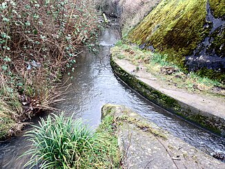
Endeicher Bach
|
Endeicher Bach in the upper reaches: Villiper Bach (9.5–8.0 km) , Katzenlochbach (8.0–3.5 km) , Lengsdorfer Bach (3.5–1.0 km) |
||
|
Mouth of the Endeicher Bach in the Dransdorfer Bach |
||
| Data | ||
| Water code | DE : 271982 | |
| location | Bonn , North Rhine-Westphalia , Germany | |
| River system | Rhine | |
| Drain over | Dransdorfer Bach → Rhine → North Sea | |
| source | South of Röttgen (around Jakobskreuz) 50 ° 40 ′ 3 ″ N , 7 ° 4 ′ 9 ″ E |
|
| Source height | approx. 175 m above sea level NHN | |
| muzzle | In Endeich in the urban canal coordinates: 50 ° 43 ′ 34 " N , 7 ° 4 ′ 27" E 50 ° 43 ′ 34 " N , 7 ° 4 ′ 27" E |
|
| Mouth height | approx. 65 m above sea level NHN | |
| Height difference | approx. 110 m | |
| Bottom slope | approx. 9.5 ‰ | |
| length | 11.6 km | |
| Catchment area | 28.298 km² | |
| Big cities | Bonn | |
|
Outlet of the piped Endeicher Bach on Siemensstrasse (Bonn) |
||
The Endeicher Bach , also called Katzenlochbach and later Lengsdorfer Bach , is an approximately eleven kilometer long right tributary of the Dransdorfer Bach and the longest brook in Bonn .
geography
course
From the source to the section “Im Mühlental”, the stream shows itself to be a near-natural / natural body of water with great botanical and zoological importance.
Especially in its course through the Katzenlochbachtal , which was a nature reserve from 2000 and has been part of the larger nature reserve Kottenforst since 2004 , the stream is still very natural. It is not influenced by sewage and is - except for the road bridge between Röttgen and Ippendorf and a hydraulic structure in front of Lengsdorf - completely unchanged in its course. The stream changes its course again and again during floods. The area around the stream is characterized by a natural alder-ash forest and softwood forests made up of various types of willow as it runs through the valley . Also characteristic are numerous sliding slopes and impact slopes , which enable a natural dynamic of the stream and form valuable habitats and ecological niches . In the environment of the river there is a diverse mosaic of place Hochstaudenfluren , grasslands , meadows, trees , hedges and small woods. In the Katzenlochbachtal, these areas are buffer zones between the course of the stream and the surrounding villages and have received a centuries-old landscape there. There is no hiking trail along the stream in this section of the route, so that humans cannot affect nature. Forestry and agriculture have hardly changed the immediate vicinity of the creek in the course of the Katzenlochbachtal in the past centuries.
In the settlement area through which it flows thereafter (in the Mühlental to the mouth), the Endeicher Bach is subject to increased pressure of use and is not very close to nature or is piped.
The Endeicher Bach is piped from Endeich and flows into the Dransdorfer Bach in Dransdorf (below the Siemensstraße bridge).
Catchment area and tributaries
The 38.7 km² catchment area is drained to the North Sea via Dransdorfer Bach and the Rhine .
| Surname | GKZ | location | Length in km |
EZG in km² |
Remarks |
|---|---|---|---|---|---|
| Villiper Bach | 271982 | right | 3.53 | 10.7 | also as the upper reaches of the Endeicher Bach |
| Gottchesbach | 2719822 | Left | 0.493 | 6.0 | |
| Hubertusbach | Left | 0.46 | 0.1 | ||
| Mahlbergbach | Left | 0.38 | 0.1 | ||
| Hohnderfeldbach | Left | 1.22 | 0.1 | 710 m of piped |
Web links
- Water profile "Endeicher Bach" in Bonn (PDF; 376 kB)
Remarks
- ↑ The information regarding length and catchment area differ in the sources given (catchment area: brook development plan 38.7 km² and water body directory of the LANUV 28.3 km², length: brook development plan 10.63 km (without Villiper Bach and its mouth in Siemensstraße) water body register 11, 57 km (with Villiper Bach to the entrance to the canal)). The brook development plan sees the Villiper brook as a tributary, the water station map as the upper reaches. The specified length in the info box refers to the brook development plan and the open water up to the piping in Endenich.
Individual evidence
- ↑ a b Topographical Information Management, Cologne District Government, Department GEObasis NRW ( Notes )
- ↑ a b German basic map 1: 5000
- ↑ a b Water directory of the State Office for Nature, Environment and Consumer Protection NRW 2010 (XLS; 4.67 MB) ( Notes )
- ↑ a b c Bach Development Plan 2008 , City of Bonn (PDF; 1.65 MB)

