Kottenforst
| Kottenforst terrace | |||
|---|---|---|---|
| View over the Kottenforst, in the background the Rhine Valley and the Siebengebirge | |||
| Systematics according to | Handbook of the natural spatial structure of Germany | ||
| Greater region 1st order | Low mountain range threshold | ||
| Greater region 2nd order | Rhenish Slate Mountains | ||
| Main unit group | 29 → Middle Rhine area |
||
| 4th order region (main unit) |
292 → Lower Middle Rhine Region |
||
| 5th order region | Middle Rhine Bay | ||
| 6th order region | 292.2 → Rhine-Ahr Terraces |
||
| Natural space |
292.24 → Kottenforstterrasse |
||
| Geographical location | |||
| Coordinates | 50 ° 39 '39.9 " N , 7 ° 5' 0.9" E | ||
|
|||
| local community | Bonn , Meckenheim , Wachtberg , Alfter | ||
| state | North Rhine-Westphalia | ||
| Country | Germany | ||
The Kottenforst is an approximately 40 km² forest area in the southwest and southwest of the city of Bonn . It belongs to the Rhineland Nature Park (1,045 km²) and forms its eastern edge. The natural space of the Kottenforstterrasse extends slightly beyond the forest area.
geography
The Kottenforst is the southern and highest part of a plateau from about 100 to 180 m above sea level. NHN , the Ville , which drops steeply to the east to the Rhine Valley , but whose slope to the west to the Swist and Erft is less pronounced (Geological Half Horst ). The natural structure includes the Kottenforstterrasse (also Kottenforstplatte ) as part of the Rhine-Ahr-Terraces of the Lower Middle Rhine area , despite a more or less the same natural features in contrast to the Ville belonging to the Lower Rhine Bay ; unlike this, it is still part of the Eifel low mountain range in geological terms . The part of the natural area Ville adjoining the Kottenforst, which was not shaped by the lignite mining of the Rhenish lignite mining area, is also called Waldville .
The Kottenforst is divided into a southeastern part between Meckenheim , Bad Godesberg and Bonn, in which partially natural open-air areas, such as the Katzenlochbachtal , fit, and a northwestern part between Heimerzheim , Buschhoven and Alfter . The village of Witterschlick lies between the two parts .
Soil science
The soil consists of Rhein gravel and gravel with a Pseudogley layer, through their waterproofness together with the flat ground to a long-lasting water-logging due to rainfall leads. Water collects in depressions in the ground; these numerous pools are called maars . In the area of the "Großer Cent" east of Heimerzheim there is an extensive depression with no natural runoff. This raised bog-like, extensive wetland has been artificially drained and afforested in the last few centuries by means of drainage measures. The natural water balance of the Kottenforst has been increasingly influenced in the past decades by the sharply reduced groundwater level as a result of the swamp measures for the lignite opencast mines west of Cologne.
history
The name Kottenforst comes from the Celtic word "coat" for forest. It was first mentioned in a document as early as the 7th century as a Franconian royal estate .
In Roman times, the Eifel aqueduct to supply the city of Cologne was built across the northern Kottenforst and then along the northeastern Villehang. The course of the line can still be seen today as a ditch over long stretches of the forest. The line has even been completely preserved in parts. Recovered sections are now set up in several of the surrounding locations.
The Kottenforst has remained largely uninhabited to this day. Exceptions were some post stations in the area of Buschhoven during Roman times . In addition, there were several military camps between Dünstekoven and Oedekoven , for example in the area where Breite and Schmale Allee meet today. Between about the 8th and 15th centuries there was also a settlement in the middle of the forest called “Hessekoven” in the latter area. The Venne ring wall , which was built by the Marienforst monastery near Bad Godesberg, has been preserved to protect against the Hungarian invasions around 954 .
In 973 Otto II confirmed to the Archbishop of Cologne the hunting rights and fishing rights in the former imperial estate .
For a long time, sometimes well into the 19th century, the Kottenforst was also used as pasture. There were larger open spaces in the middle of the forest that were grazed. In addition, extensive acorn fattening was operated. For example, around 820, the noble Gernhilde, owner of the Oberbachem manor , had the right to have 30 pigs driven to fattening in the Kottenforst. Extensive clearings and field names such as “Dünstekovener Kuhweide” still bear witness to this type of use. The name of the Bonn district of Schweinheim is also reminiscent of the acorn fattening that used to be practiced in the Kottenforst. Most of the open spaces of the Kottenforst, apart from some arable land in the northern part, have now been largely reforested.
The real estate on Kottenforst had from 1064 together with the Good Muffendorf (now Victory Hof) the Abbey Siegburg . As vassals of this abbey, the so-called "four men", the owners of the castles in Adendorf and Odenhausen as well as the Thurmhof and the Binsfelderhof in Friesdorf , had wood and grazing rights in the Kottenforst. In 1549, Siegburg Abbey sold these basic rights to the Archbishops of Cologne, who already had the right to hunt large game in the Kottenforst and had built hunting castles in Poppelsdorf and Buschhoven .
Around 1727, the Kottenforst was systematically surveyed for the first time under Clemens August von Bayern in order to create avenues for his parforce hunts . These mostly wide avenues were piled up dead straight and ditches were provided on both sides because of the wet subsoil. In 1730, Clemens August had the Schönwaldhaus forest service building built and from 1754 to 1756 the Herzogsfreude hunting lodge was built in Röttgen at the center of this system of avenues. The exact alignment of the paths in relation to the electoral palace and also to Schloss Brühl is remarkable . This path system has largely been preserved to this day. After the French invaded in 1794, the time of princely hunts was over; In 1807 the hunting lodge was demolished and the Kottenforst became the Forêt Impériale and, in the time of the Prussians, a state forest .
1879 was the Kottenforst far from Röttgen called " Kaisereiche " by the then Prince William of Prussia, later Emperor Wilhelm II. , Who was then at the Rheinische Friedrich-Wilhelms-University of Bonn , planted studied "highest of all by hand." It was meant to serve as a reminder of the joys he enjoyed in this area. Directly opposite the imperial oak is the Prince Oskar oak to the north and the Prince Friedrich oak planted in 1904 to the east . Princes Eitel-Friedrich and Oskar had also studied in Bonn. The three oaks are at the crossroads where the hunter's house is located. The oaks are popular destinations today. Only a few hundred meters further on, on the “Communicationsweg” to Villiprott, is the fallen natural monument, Thick Oak . From a mighty center piece of the tree that fell in 2010, the artist Klaus Simon created principles for the Bonn Namen-Jesu-Kirche . The archaeological monument Ringwall Venne can be reached in 5 km.
Here and there are crosses on the forest paths. Some of these are from the time of Elector Clemens August, such as the Wolf Cross on Villiper Allee, in more recent times some are reminiscent of fatal accidents, such as the Zavelberg Cross on Professorenweg.
Natural park
The Kottenforst was the nucleus of the Kottenforst Nature Park in 1959, which was renamed the Kottenforst-Ville Nature Park after an expansion in 1967 and has been called the Rhineland Nature Park since 2005 - after various additional extensions .

Protected area and protected area management
Large parts of the Kottenforst are now nature reserves ( fauna-flora-habitat ). The protected area supervisor of the FFH area Kottenforst is the Biologische Station Bonn e. V. This directs its care in this large forest area above all to the open land biotopes located in it or bordering it, such as meadows and pastures, deforestation areas and bodies of water, which also include the Katzenlochbachtal .
forestry
 Composition of the forest in percent (1980)
|
The Kottenforst is predominantly state-owned, another large part is the city forest of the city of Bonn. The regional forest office "Rhein-Sieg-Erft" is responsible for the forest management of the state forest, which maintains an office building in Bonn-Röttgen, but has its headquarters in Eitorf . It is responsible for a total forest area of around 60,000 hectares, making it the second largest in North Rhine-Westphalia after the Münsterland regional forest office . The Urban Green Office is responsible for the forest in the city of Bonn. The area of the Kottenforst is spread over the areas of the following municipalities: City of Bonn - where the largest part of the forest is located - Alfter , Meckenheim , Swisttal , Wachtberg and Bornheim . |
The first forestry forest description from 1829 presented the then by overexploitation out run-down condition of the forest: only 335 ha oak - and book - Hochwald and 139 hectares of pine cultures were forestry valuable. The rest consisted of thinned middle and low forest . The Kottenforst was systematically reforested as early as the time of the Prussian ownership . However, spruce and pine trees were often planted in monocultures. This development has only been corrected in the past few decades by increasingly replacing the stands with mixed deciduous forest typical of the location.
Every year around 20,000 solid cubic meters of wood are felled in the Kottenforst and processed in sawmills in the vicinity - including for the construction of stairs in Wachtberg- Fritzdorf . The Bonn company Johannes Klais Orgelbau partly uses wood from the Kottenforst.
Conflict of goals
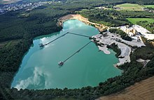
On the edge of the Kottenforstes there was and is a conflict between ecology and economy in some places , mainly due to the occurrence of coveted gravel and sand . Clay and rare high-purity white quartz gravel are stored in the Buschhoven - Volmershoven area and in the northern part of the Waldville between Weilerswist and Bornheim . The mining takes place in the form of opencast pits . Protests, protection associations and legal disputes have already taken place because of the operators' wishes for expansion areas.
Attractions
- Roman Eifel aqueduct
- Baroque hunter's lodge
- Ringwall Venne as a medieval refuge near the forester's house Venne
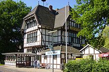
- Kottenforst station
- Lüfthildi's wayside shrine, a stele created by Martin Thiebes in 2020
- Iron man
- Wolf cross
- Thick oak
- Siebenschuss , memorial at the forester's house Buschhoven
- View of Godesburg and the Siebengebirge
- Waldau on the northern edge of the Kottenforst with the House of Nature, wildlife park
- Nature reserve Kiesgrube Dünstekoven
- Dürrenbruch nature reserve
- Böhling (viewpoint near Alfter with a view of Bonn)
- Hangmotte Alfter , medieval refugee castle near the Böhling
Public transport
Main article: Stop / transfer point Meckenheim Kottenforst
The former train station and today's Kottenforst stop ( Meckenheim Kottenforst since 2014 ) is located on the Voreifelbahn ( Bonn - Euskirchen ), on which the S 23 runs for local rail passenger transport .
The station is located in the Meckenheim area in the Lüftelberg district in the immediate vicinity of the Alfter community. The former reception building is a popular summer excursion destination with large outdoor restaurants. In 2012, the Deutsche Bahn stop was converted to the current station standard and equipped with an elevated platform.
The Kottenforst can also be reached directly with several bus lines, e.g. B. the VRS lines 602 (Waldau), 603 (Röttgen), 615, 800, 843, 845, 855.
The tariff of the Verkehrsverbund Rhein-Sieg (VRS) applies and the NRW tariff applies to all tariff areas .
Others
The gnarled head beeches are a specialty . A type of wood extraction practiced here earlier led to cripple growth in the beech trees with a sometimes bizarre appearance (ghost forest). Due to the old age (approx. 250 years) these head beeches are now enormously in danger of breaking or threatening to tip over, which is why the city of Bonn already wanted to close forest paths in the Waldau , which led to violent protests among the population. At the moment (2018) it is still possible to enter the slalom, but warning signs are used to indicate the high risk.
Since 2017, the Kottenforst has also been suffering from the extremely increased drought and heat, which has led to severe bark beetle infestation and catastrophic tree deaths with huge clear cuts as a result. With the project series “Forest.anders.think”, the regional forest office “Rhein-Sieg-Erft”, in cooperation with various organizations and artists, would like to shake people up and draw attention to the consequences of climate change. One of the first activities is the “Zeitwende” project in June 2020. At the end of a clear cut of around 200 hectares, a wall of dead spruce stands in front of a wall of dead spruce with a warning in large white letters “Zeitwende”. At the front of the forest path is the installation Angel of Cultures by the artists Carmen Dietrich and Gregor Merten from Burscheid . The installation is "a wake-up call for all of us to do business sustainably, to renounce unbridled consumption and to end the global destruction of the environment - for a move towards considerate treatment of nature and peaceful and fair coexistence between people." (Excerpt from the information column) . The project area is located on Gudenauer Weg, about 2 km south of Ippendorf .
Kottenforst is the title of a crime novel by the Bonn author Alexa Thiesmeyer . The action takes place in the forest area and the neighboring districts, in particular Röttgen and Ückesdorf .
Individual evidence
- ^ Institute for Regional Studies (ed.); Heinrich Müller-Miny (arrangement): Geographical and regional explanations for the topographical map 1: 50000 . 1. Delivery, self-published by the Federal Institute for Regional Studies and Spatial Research, Bad Godesberg 1963, p. 28.
- ↑ Federal Research Institute for Regional Studies and Regional Planning (ed.); Ewald Glässer (arrangement): The natural spatial units on sheet 122/123 . Self-published, Bonn-Bad Godesberg 1978, ISBN 3-87994-328-1 , pp. 18, 35 (= Geographische Landesaufnahme 1: 200,000. Natural spatial structure of Germany ).
- ↑ Bruno P. Kremer: The green hinterland of Bad Godesberg. The Kottenforst - a unique living and adventure space . In: Godesberger Heimatblätter: Annual volume of the Verein für Heimatpflege und Heimatgeschichte Bad Godesberg eV , ISSN 0436-1024 , Volume 53 (2015), Verein für Heimatpflege und Heimatgeschichte Bad Godesberg , Bad Godesberg 2016, pp. 183-201 (here: p. 187 ).
- ↑ Clemens Dasler: Forest and Wildbann in the early German Empire. Wildlife certificate from 973, 2001, ISBN 978-3-412-12800-5 ( limited preview in Google book search).
- ↑ World Database on Protected Areas - Kottenforst Nature Reserve (English)
- ↑ 5308-303 Kottenforst Forest Reserve. (FFH area) Profiles of the Natura 2000 areas. Published by the Federal Agency for Nature Conservation . Retrieved November 20, 2017.
- ↑ 5308-401 Kottenforst-Waldville bird sanctuary. (EU bird sanctuary) Profiles of the Natura 2000 areas. Published by the Federal Agency for Nature Conservation . Retrieved June 5, 2020.
- ↑ Annual report 2011. (PDF; 1.6 MB) (No longer available online.) Biologische Station Bonn e. V., December 5, 2011, archived from the original on February 1, 2014 ; accessed on January 27, 2014 .
- ^ Mario Quadt: Extension of the gravel pit in front of the court. In: General-Anzeiger (Bonn) . July 15, 2016, accessed August 9, 2018 .
- ↑ Modernization offensive 2: DB will modernize 108 train stations in North Rhine-Westphalia over the next few years. Deutsche Bahn, press release from December 16, 2011.
- ↑ Rolf Kleinfeld: Road blocking hotly discussed. In: General-Anzeiger (Bonn) . April 15, 2016. Retrieved November 29, 2018 .
- ^ Stefan Hermes: Regional Forestry Office: Art project in the Kottenforst shows the negative effects of climate change. In: General-Anzeiger (Bonn) . June 15, 2020, accessed June 25, 2020 .
- ↑ Project: Ville forests, turning point in the Kottenforst. Landesbetrieb Wald und Holz Nordrhein-Westfalen, Regionalforstamt Rhein-Sieg-Erft
literature
- Werner D'hein: Kottenforst. 13 hikes through a historical cultural landscape . Gaasterland-Verlag, Düsseldorf 2008, ISBN 978-3-935873-21-5 .
- Bruno P. Kremer (also publisher): The Kottenforst. A Rhenish cultural and recreational landscape . Wienand, Cologne 1999, ISBN 3-87909-648-1 .
- Albert Hexges: The Kottenforst. A contribution to the forest history of Kurköln with special consideration of the development of forest ownership, forest law, forest organization and forest use. In: Bonner Geschichtsblätter, Volume 35 . Bonn 1984, pp. 23-98.
- State survey office of North Rhine-Westphalia (publisher): Kottenforst-Ville Nature Park . Topographic map 1: 50,000, also a hiking map of the Eifelverein . 1980, DNB 551928581 (in cooperation with the Kottenforst Forestry Office, with description on the reverse).


