Waldau (Bonn)
The Waldau is part of the Bonn city forest . It is located in the Venusberg district on the southern slope of the mountain of the same name and forms the northernmost part of the Kottenforst . It is best known as a destination for excursions.
geography
The Waldau is located on the southern ridge of the Venusberg, between Ippendorf , the Venusberg district and the campus of the Bonn University Hospital in the north, Friesdorf in the east, Röttgen in the south and Ückesdorf in the west. South, state forest and close the Rhineland Nature Park at. The Waldau already belongs to the elevated terrace west of the Rhine and lies at around 170 meters above sea level. The soil is clay to gravel . The area of the Waldau as an official part of the city forest is 160 ha . The Engelsbach flowing through the Melbe valley to the Rhine has its source here.
nature
The Waldau is largely composed of mixed forest. The original vegetation consisted mainly of oak and hornbeam , many pines were added through forestry . The gnarled head beeches or spawning oaks , which are up to 250 years old, are particularly striking . A type of wood extraction practiced here earlier led to the beeches becoming crippled and sometimes giving them a bizarre appearance (ghost forest). See information board “Head booking - Witnesses from the past”. In the spring dominated Buschwindröschen the forest floor, in the summer at the St. John's fall many fireflies on.
Wildlife species in the Waldau include the tawny owl , Bechstein's bat , fallow deer , badger , common toads and grass snakes .
history
Since the Middle Ages, the Waldau, like the surrounding forests, has been used for felling and as a hut forest . Around 1750, Elector Clemens August opened up the Kottenforst with a systematic network of paths, and the Dottendorfer Allee, which runs through Waldau, dates from this period . In the late 19th century there was major clearing and agricultural use, and there was also an experimental farm of the University of Bonn on the Annaberger Feld in the southwest of the Waldau.
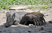
In 1908, the city of Bonn bought the farm on the Waldau and a large part of the area. Numerous bomb craters in the area originate from the Second World War . After the war there was major deforestation, and later the reforestation of the forest areas that had been lost as a result and through agriculture began. In 1961 a game reserve was set up in which wild boar , red deer and fallow deer can be observed outdoors. In 1989 the House of Nature was opened, which provides information on geology, animal and plant life in the area.
Attractions
The Waldau attracts visitors from Bonn and the surrounding area with the game reserve, which is popular with children. The Haus der Natur, designed as a “forest information center”, consists of a natural history museum and a forest nature trail . There is also a restaurant in the old manor building with a modern extension.
literature
- Holger Willcke: The heart of the Bonn city forest. The Waldau. In: General-Anzeiger Bonn, April 24, 2007, p. 8
- Ursel and Jürgen Zänker: Building in Bonn room 49–69. Attempt to take stock . In: Landschaftsverband Rheinland (Hrsg.): Art and antiquity on the Rhine . Guide to the Rheinisches Landesmuseum Bonn . No. 21 . Rheinland-Verlag, Düsseldorf 1969, p. 177/178 .
Web links
Coordinates: 50 ° 41 ′ 27.1 ″ N , 7 ° 5 ′ 39.3 ″ E


