
Bornheim (Rhineland)
| coat of arms | Germany map | |
|---|---|---|

|
Coordinates: 50 ° 46 ' N , 6 ° 59' E |
|
| Basic data | ||
| State : | North Rhine-Westphalia | |
| Administrative region : | Cologne | |
| Circle : | Rhein-Sieg district | |
| Height : | 62 m above sea level NHN | |
| Area : | 82.69 km 2 | |
| Residents: | 48,321 (Dec. 31, 2019) | |
| Population density : | 584 inhabitants per km 2 | |
| Postal code : | 53332 | |
| Primaries : | 02222, 02227 , 02236 | |
| License plate : | SU | |
| Community key : | 05 3 82 012 | |
| LOCODE : | DE BXH | |
| City structure: | 14 districts | |
City administration address : |
Rathausstrasse 2 53332 Bornheim |
|
| Website : | ||
| Mayor : | Wolfgang Henseler ( SPD ) | |
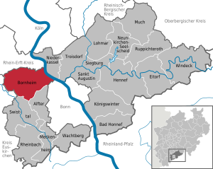
| Location of the city of Bornheim in the Rhein-Sieg district | ||
  |
||

Bornheim ( ) is a medium-sized city in the Rhein-Sieg district in the south of North Rhine-Westphalia . Due to its central location between Cologne and Bonn , it is one of the fastest growing cities in the region and is now the third largest city in the Rhein-Sieg district. The Eifel aqueduct , a Roman aqueduct , through which Roman Cologne was supplied with drinking water at that time , once ran through the districts of Waldorf, Kardorf, Merten and Walberberg .
geography
Bornheim lies between the two major cities of Cologne and Bonn and extends with its districts from the plains on the left bank of the Rhine of Cologne Bay in the east over the slope of the foothills in the west to the still wooded plateau of the Ville . The highest point of the urban area is at the upper end of the Roisdorf district at 165.6 m above sea level. NHN ( ⊙ ), the lowest point is on the Rhine bed at Widdig at 46.6 m above sea level. NHN indicated.
The city borders on the federal city of Bonn in the south, the municipalities of Alfter and Swisttal in the southwest, the municipality of Weilerswist in the west, the cities of Brühl and Wesseling in the north, and on the Rhine on the city of Niederkassel in the east.
City structure
Bornheim is divided into 14 districts. these are
- the "foothills"
- Bornheim (with Botzdorf, 8,199 inhabitants)
- Brenig (with Bisdorf, 2,340 inhabitants)
- Dersdorf (1,218 inhabitants)
- Hemmerich (1,561 inhabitants)
- Kardorf (2.153 inhabitants)
- Merten (with Trippelsdorf, 5,638 inhabitants)
- Roisdorf (6,070 inhabitants)
- Rösberg (1,478 inhabitants)
- Sechtem (5,241 inhabitants)
- Walberberg (4,730 inhabitants)
- Waldorf (with Üllekoven, 3,447 inhabitants)
- and the "Rheindörfer"
history
The region of today's city of Bornheim was settled in prehistoric times. To the east of the foothills, a concentration of sites can be seen on the Lossterrassenplatte left bank of the Rhine between the districts of Bornheim and Sechtem. Barrows with grave goods as well as stone tools were found here, which prove a settlement in prehistoric times. An Iron Age homestead was located in the Hersel district.
Furthermore, two refuges were found in the vicinity. These were quite simple ramparts, built by Teutons or Celts to protect their settlers. For example, the Aldeburg in the Walberberg Forest (ring wall), still recognizable in its ground plans, and a section wall on the Stromberg in the south of the Rösberg forest near the Dobschleider Hof.

The presence of the Romans from 50 BC to 450 AD is also documented by buildings. Remnants of the Roman Canal from the Eifel to Cologne are still present in the Bornheim area or can be opened up as cuts in the terrain. The Roman Villa in Botzdorf was discovered in 2002.
Even then, the promontory served as a fruit and vegetable garden for the Roman settlements of Bonna ( Bonn ) and Colonia Claudia Ara Agrippinensium (Cologne).
Many burial sites and a few place names tell of the conquest and numerous village foundations by the Franks , because Merovingian sites are also spatially related to places with the suffix “home”. Examples for clarification are the names of the places Bornheim, Mehlem, Mülheim (Bonn), Schweinheim, Stockheim, Holzem, Niederbach and Oberbachem, Ließem, Hochheim or Stockem.
The main town Bornheim is documented as "Brunheim" in Bonngau , in the county of Count Ehrenfried , for the first time on August 2, 945. As part of the medieval Heerstraße, today's Königstraße was an important transport route from Bonn to Aachen very early on . It was first mentioned in 1272 as "Connixstroß". The first documented place within the city of Bornheim is the Widdig district, which was first mentioned in 804 as "Wittheich".
In the 10th and 11th centuries, almost all the villages with their landmarks came as endowments to monasteries and free aristocratic monasteries in Bonn ( Cassius pen ) and Cologne (also to the Cologne Cathedral Chapter ).
From the office of the guardian , as administrator of the endowments , the manors grew under the electoral sovereignty of the Electorate of Cologne . Wilhelm Schilling von Buschfeld , Ritter, Herr zu Bornheim, was mentioned in a document between 1173 and 1198 as the first Cologne ministerial from the family of the Lords of Bornheim . His son called himself Ritter Wilhelm von Burnheim . The lords of Bornheim in turn became the founding fathers of various Rhenish aristocratic families, including Landsberg , which is still flourishing today .
Bornheim Castle


In the years between 1728 and 1732 , the Bornheim Palace was built for the barons Waldbott von Bassenheim in the style of a Maison de Plaisance ( pleasure palace ) , presumably according to the plans of Johann Conrad Schlaun , a Baroque architect . Only the outer bailey remained of the previous buildings , nothing of the former gate tower with drawbridge remained. A baroque entrance arch with a stone bridge and a bell tower was built as a replacement. Other remains of the outer bailey, such as the bell tower, fell victim to a major fire on February 4, 1972.
The lords of the castle in the 19th century changed several times. The acquirers were Gerhard Freiherr von Carnap in 1826 , Wenzel Graf von Boos-Waldeck in 1859 and Heinrich Freiherr von Diergardt in 1872. From 1964 to 1974/75 at the latest, the property served as the residence of the Ambassador of Iraq to the Federal Republic of Germany. Bornheim Castle is still owned by the Barons von Diergardt, who leased it to the Teutonic Order , which operates the Bornheim Castle Clinic there.
Incorporations
For the electoral period, when the first local boundaries were formed, the modern city was divided into eight areas for Electoral Cologne office Brühl belonged.
With the entry of the French revolutionary army, the old divisions were abolished. The French promised themselves military and economic advantages from this. Self-government in the villages was prevented and all power was therefore with the French. In 1798, the occupied territories were then divided into administrative zones, as this meant better use of the annexed Rhineland. Due to the new border between the departments of Rhine / Mosel and Roer, starting on the left bank of the Rhine between Hersel and Bonn and from there straight to the west, the splendor of Alfter was cut up with Alfter and Roisdorf. Thus Roisdorf was separated from Alfter and Roisdorf became its own municipality. The Dingstuhl Waldorf was also divided into the communities of Waldorf and Hemmerich-Kardorf. The glory of Bornheim remained and later formed the joint community of Bornheim with the other three communities with the seat of administration in the Bornheim court and office building on Burgstrasse with 3,633 inhabitants in 1740.
Merten, Rösberg, Sechtem and Walberberg were combined to form the Sechtem municipality with 2,880 inhabitants. Hersel, Uedorf, Widdig, Urfeld, Keldenich and Wesseling were combined to form the Hersel municipality with 2,328 inhabitants. These three districts with a total of 8,841 inhabitants belonged to the canton Brühl , in the arrondissement Cologne of the Rur department with a prefecture in Aachen. The three joint municipalities of Hersel, Sechtem and Bornheim were renamed a short time later in the Mairien Hersel, Sechtem and Waldorf.


During the 19th century, the Mairie office (from 1816 mayor's office and office from 1928) Waldorf moved several times, because every new mayor wanted the office close by. All eleven mayors had a different seat in their office, so that a new town hall was built in Bornheim in 1883 after there had previously been major discussions about the new location. Ultimately, however, a majority for Bornheim and against the locations Waldorf and Roisdorf prevailed, since Bornheim was already the largest place at that time and was also geographically central within the mayor's office. At that time, the mayor's office in Waldorf was divided into the four communities Bornheim-Brenig, Kardorf-Hemmerich, Roisdorf and Waldorf.
As a result of the global economic crisis in 1929, most cities and municipalities were heavily in debt, such as Bonn, Hersel and Sechtem, because these municipalities had a large number of unemployed due to the decline of their industry. At that time, the Bornheim-Brenig community in the Waldorf district was an exception, where a solid financial policy, relatively low unemployment and large savings resulted in an unbelievable excess of 60,000 Reichsmarks at the time.
Due to a town hall in Merten built in 1927 shortly before the economic crisis and the crisis in most of the factories, the closure of many briquette pits and the problems of Berggeist AG in Brühl, the Sechtem district and all affiliated communities were in such a financial emergency that on May 16, 1931 a personal union with the Waldorf Office was concluded. On June 20, 1931, Waldorf Mayor Ditz also took over the official business of the Sechtem office. As a result, due to a lack of space, a villa next to the town hall was bought and converted for office purposes.
In the third office, too, the time was ripe for a new town hall, although the question was whether it should be built in the main town of Hersel or in the affiliated municipality of Wesseling, which has become more and more important in recent years. The people of Wesseling justified their suggestion by stating that their location had become very important due to the expanded port and the growing industry. In addition, the municipality of Wesseling played its biggest trump card by donating the building site for the new town hall to the Hersel Office, which also decided the question of space.
In the summer of 1932 the rumor spread that the municipalities of Wesseling and Keldenich were to break away from the Hersel office in the Bonn district and be incorporated into the Cologne district. The rumor was confirmed and the citizens of the Hersel Office were presented with a fait accompli by the Prussian state government. The municipalities of Keldenich and Wesseling were separated from the association of the Hersel office on October 1, 1932 and merged with the Berzdorf municipality from the Brühl office to form the new Wesseling office. The greatly reduced Hersel Office thus lacked the town hall, the mayor and the staff. The communities Hersel, Uedorf, Widdig and Urfeld thus came to the Waldorf Office and were also administered from Bornheim.
In addition, the district president dissolved the three registry offices Sechtem, Waldorf and Hersel and founded the new registry office Bornheim. This point in time can be described as the hour of birth of today's city of Bornheim.
On May 7, 1934, at the request of the official members of the Prussian State Ministry, the Waldorf office was renamed “Bornheim Office”. On April 1, 1935, the district president in Cologne approved the merger of the Bornheim and Sechtem offices to form the new Bornheim office. The two offices promised themselves considerable savings and a strengthened position from this. In addition, the Hersel Office was finally attached to the Bornheim Office, so that the following structure emerged on July 1st:
- Bornheim-Brenig, Kardorf-Hemmerich, Roisdorf and Waldorf were merged to form the new Bornheim community.
- Hersel, Uedorf, Widdig and Urfeld were merged to form the new, larger municipality of Hersel.
- Merten, Rösberg, Sechtem and Walberberg were merged to form the new, larger municipality of Sechtem.
These three new communities formed the Bornheim office.
On August 1, 1969, the law on the local reorganization of the Bonn area ( Bonn Law ) created the “new” municipality Bornheim by merging the three municipalities of Bornheim, Hersel (excluding the Urfeld district) and Sechtem, while the office was dissolved Bornheim formed.
Since January 1, 1981, the Bornheim community has also been known as the “City of Bornheim”.
politics
City council
The city council is the municipal representative body of the city of Bornheim. The citizens decide on the composition every five years. The last election took place on May 25, 2014. On November 7, 2014, a councilor resigned from the CDU, but remains in the council as a non-party. Since then, the CDU only has 19 seats in the council. On December 2, 2015, the pirate Jürgen Weiler left the ABB group. Since then, the ABB is no longer a parliamentary group.
|
Allocation of seats in the city council
A total of 48 seats
|
Council election 2014
Turnout: 55.72%
% 50 40 30th 20th 10
0
42.13
26.29
10.79
7.37
6.16
3.57
3.25
0.43
n. k.
Gains and losses
|
Community development
When the greater Bonn area was reorganized in 1969, the Bornheim district, which included the Bornheim, Hersel and Sechtem communities, became the Bornheim community. The village of Urfeld , which belongs to the municipality of Hersel , came to Wesseling . Bornheim has been a town since 1981.
Bornheim was ruled by the CDU from 1946 to 2004 with an absolute majority. Only after 58 years did it lose its absolute majority and no longer provide the mayor. From 2009 to 2014 an alliance made up of the CDU and Bündnis 90 / Die Grünen ruled Bornheim. The social democrat Wolfgang Henseler has been mayor since 2004 .
Town twinning
Bornheim has been twinned with Bornem in Belgium since 1989 and with Mittweida in Saxony since 1991 . Since 2010 there has been a town partnership with Zawiercie in Poland .
coat of arms
_COA.svg) |
Blazon : “A red bar in gold, covered with a grid made up of 4 right and 4 left silver sloping strips. At the front flank point a fallen, black flaming sword covered by the red bar in the middle. " |
|
Foundation of the coat of arms: The lineage of the Lords of Bornheim is documented for the first time in 1107. Bornheim Castle was first mentioned as a knight's seat in 1147. The lattice beam is the coat of arms of the von Bornheim family and can be found in the Breniger Schöffensiegel in 1319.
The flaming sword from today's coat of arms of the city of Bornheim, on the other hand, refers to the old aldermen's seal of Waldorf from 1380, which is the attribute of the parish patron of Waldorf St. St. Michael is. |
Culture and sights


- Bornheim Castle
- The island of Herseler Werth on the border with Hersel
- The listed parish church of St. Servatius
- The listed Old Evangelical Church Bornheim
Schools and educational institutions
Bornheim itself has a primary school (Johann-Wallraf-Schule), a comprehensive school (Europaschule) and a grammar school (Alexander-von-Humboldt-Gymnasium (AvH)). Further educational institutions are listed in the respective districts.
- Bibelseminar Bonn - theological college
- Johann Wallraf School - primary school
- Europaschule Bornheim - comprehensive school
- Alexander von Humboldt High School
- Volkshochschule Bornheim / Alfter (municipal training center for the city of Bornheim and the municipality of Alfter)
- Bornheimer Musikschule e. V.
- Bornheim City Library
economy
Bornheim has around 2,600 businesses in the areas of trade and craft, plus 96 restaurants. The intensive agriculture with fruit and vegetable cultivation is important here in the climatic / pedological favorable area of the foothills and their foreland.
Since 2014, Bornheim asparagus grown and marketed in and around Bornheim has been protected by the European Union with a designation of origin .
One of the headquarters of Landgard is located in the Roisdorf district , one of the largest German marketing institutions for fruit and vegetables , which emerged from the auction cooperative founded in 1920. There are also the Roisdorf mineral springs, which promote and fill various mineral waters and produce non-alcoholic refreshments.
The companies RHENAC Stanzteile GmbH and EN ElectronicNetwork AG, which emerged from the Moeller company, are now located in the former Moeller production site in the Hersel industrial park .
Tourism
Bornheim is close to the Rhineland Nature Park . It has a large number of historical buildings, churches, monasteries, castles and old farmsteads as well as traces of the Romans. There are numerous hiking trails, including the Heinrich-Böll-Weg , which opened in 2017 on the occasion of the 100th birthday of the Nobel Prize for Literature , which leads past the former home of the Böll family to the grave of Heinrich Böll and his wife in the Bornheim district of Merten.
traffic

Bornheim's location on the heavily trafficked left Rhine route between Bonn and Cologne ensures inexpensive public transport connections:
- The regional trains Rhein-Wupper-Bahn and MittelrheinBahn between Wuppertal / Cologne and Bonn - Mehlem / Koblenz stop in Roisdorf and Sechtem.
- The rail line 16 runs on the Rhine track , a track of the former Köln-Bonner railways (CFU). It travels from Bonn to Cologne via Wesseling along the Rhine. Stops are in Hersel, Uedorf and Widdig.
- Tram line 18 runs on the Vorgebirgsbahn , another KBE route. It travels from Bonn to Cologne via Bornheim, Brühl and Hürth along the foothills. Stops are "Roisdorf West", "Bornheim Rathaus" and in Bornheim, Dersdorf, Waldorf, Merten and Walberberg.
- The tram line 68 runs on the route between Bornheim and Ramersdorf on the route of line 18. Stops are “Roisdorf West”, “Bornheim Rathaus” and “Bornheim”.
- The RVK bus lines 817 ( Rheinbach - Swisttal-Heimerzheim - Brenig - Bornheim - Roisdorf - Hersel) and 818 (Sechtem - Merten - Rösberg - Waldorf - Dersdorf - Bornheim - Roisdorf - Hersel) connect the individual districts of Bornheim, the minibus line 882 connects Bornheim with the municipality of Alfter . In addition, there is the 790 collective call taxi line between the districts.
- Furthermore, the SWB bus route 633 connects the Bornheimer villages Sechtem, Bornheim and Roisdorf via Alfter and Bonn-Duisdorf, and the bus route 604 (Hersel - Buschdorf - Auerberg - Nordstadt - Bonn Hauptbahnhof - Lengsdorf - Endenich - Ückesdorf ) connects Hersel to the Bonner North.
- Bornheim belongs to the tariff area of the Verkehrsverbund Rhein-Sieg (VRS).
Bornheim has a total of 348.1 km of roads and paths (as of 2018). On January 1, 2018, 33,028 motor vehicles were registered in the city, 27,489 of which were cars.
religion

Roman Catholic Church
There are twelve Catholic parishes in the Bornheim urban area , which are grouped into two parish associations:
- Pastoral care area Bornheim - on the Rhine and foothills
- St. Sebastian (Roisdorf)
- St. Servatius (Bornheim)
- St. Evergislus (Brenig)
- St. Aegidius (Hersel)
- St. Georg (Widdig).
- Pastoral care area Bornheim - Vorgebirge
- St. Albertus Magnus (Dersdorf)
- St. Michael (Waldorf)
- St. Joseph (Kardorf)
- St. Aegidius (Hemmerich)
- St. Markus (Rösberg)
- St. Martin (Merten)
- St. Gervasius and Protasius (Sechtem)
- St. Walburga (Walberberg) .
From 1925 to 2007, the Dominican monastery of St. Albert existed in and later around the Rheindorfer Burg in Walberberg . Until the 1970s, the Dominicans owned a philosophical and theological college here, and the “Walberberger Institut” existed as a folk college until 2007.
In Botzdorf, Brenig and other Bornheim villages there is still the old custom that on Good Friday and Holy Saturday children go to the clatter and thus replace the ringing of bells. The custom of Beierning has been preserved in several places in Bornheim , where the church bells are struck manually in certain rhythms and melodies on special holidays.
Protestant church

- Evangelical parish foothills
- 1. Parish: Bornheim (Reconciliation Church, Old Church), Brenig and Roisdorf
- 2. Parish: Dersdorf, Hemmerich (Markuskirche), Kardorf, Merten, Rösberg and Waldorf
- Parish of Hersel
- Hersel (Dreieinigkeitskirche), Sechtem (Die Arche), Uedorf and Widdig (and Aegidienkapelle Bonn-Buschdorf)
- Parish of Brühl
- Martin Luther Church (Walberberg) (1st parish of Brühl)
Free Churches
In Bornheim-Roisdorf there is a free church, the Evangelical Free Church Bornheim (Baptists). The Bibelseminar Bonn , a theological college with a free church background, has had its training center in Haus Wittgenstein (Roisdorf) since 1996. Here, young people are trained on a biblical basis to become youth officers, pastoral workers, pastors and missionaries.
Judaism

Königstrasse 55. Location of the synagogue until November 1938
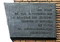
Plaque


Bornheim owned a synagogue until 1938 . It was burned down by the Bornheim National Socialists on the Night of the Reichspogrom . A plaque in Königstraße commemorates this place of worship. Only the three cemeteries in Bornheim (Botzdorf), Walberberg and Hersel bear witness to the Jewish community in Bornheim . The Jewish people of Bornheim, as far as they could not emigrate, were almost all murdered in the National Socialist concentration camps . "Stumbling blocks" were laid in Bornheim to commemorate her. The Jewish cemeteries were documented in a 2004 study commissioned by the city of Bornheim.
Personalities

Honorary citizen
- Heinrich Böll (1917–1985) lived in the Merten district from 1982 to 1985 and is buried there in the old cemetery. On the occasion of the 25th anniversary of his death, Böll was made an honorary citizen posthumously. His son René received the certificate on July 16, 2010.
- Franz Farnschläder, Bornheim (1912–1992), honorary citizen since January 17, 1992
- Peter Langel, Widdig (1919–2003), Deputy Mayor, honorary citizen since 1985
- Heinz Nowicki (1912–2000), honorary citizen since 1975
- Ferdinand Rott, Merten (1894–1958), honorary citizen since August 20, 1956
- Sister Secunda (1878–1957), Augustinian , in Bornheim Abbey since 1909, honorary citizen since June 13, 1957
- Franz von Kempis, Sechtem (1870–1960), honorary citizen since 1958
sons and daughters of the town
- Ernst Volckheim (1898–1962), officer and co-founder of the German Panzer Force
- Franz Bosbach (* 1952), historian
Personalities associated with the city
- Paul von Rusdorf (around 1385–1441), Grand Master of the Teutonic Order from 1422 to 1441, came from the knightly family of the Lords of Roisdorf. He is buried in the Annenkapelle of the Marienburg / West Prussia.
- Part of the family of Klemens Wenzel Lothar von Metternich (1773 to 1859) lives under the name Metternich in Waldorf.
- Otto Schmitz-Hübsch (1868–1950), fruit growing pioneer and breeder, founded Germany's first pure fruit estate in Merten in 1896.
- Günter Lamprecht (* 1930), actor, lives in Bornheim.
- Hans-Helmuth Knütter (* 1934), political scientist and author, lives in Bornheim.
- Gunter Desch (* 1937), German medical officer, inspector of the medical and health services of the Bundeswehr, lives in Bornheim.
- Toni Schumacher (* 1938), soccer goalkeeper, lives in Bornheim-Hemmerich.
- Georg Bollenbeck (1947–2010), German and cultural scientist, lived in Bornheim-Brenig.
- Klaus Ludwig (* 1949), the former racing driver and multiple German touring car champion, lived in Bornheim-Roisdorf.
- Manfred Lütz (* 1954), psychotherapist and book author, lives in Bornheim.
- Bernd Stelter (* 1961), carnivalist and television comedian, lives in Hersel.
- Johannes B. Kerner (* 1964), sports presenter, lived in Hersel as a child.
- Arnd Schmitt (* 1965), Olympic champion in epee fencing in 1988, lives in Bornheim.
- Sebastian Hartmann (* 1977), Member of the Bundestag, Chairman of the North Rhine-Westphalian SPD, lives in Sechtem.
- Christian Knees (* 1981), racing cyclist (including winner around Cologne 2006 and participant in the Tour de France 2006 ) lives in Bornheim.
- Célia Šašić (* 1988), national soccer player from Hersel.
literature
- Horst Bursch: The settlement names of the city of Bornheim, A study of the toponymy and settlement history of the foothills , Bornheim 1983.
- Wilhelm Ewald: Rhenish seals. 6 Vols. Vol. III Plate 10 (Publications of the Society for Rhenish Regional Studies 27), Bonn 1906–1975.
- Klaus Grewe : The Roman Canal Hiking Trail. An archaeological hiking guide. Ed .: Eifelverein, ISBN 3-921805-16-3 .
- Dietrich Höroldt : Bornheim. A young city based on old culture. History from the Stone Age to the present. JP Bachem Verlag 2008, ISBN 978-3-7616-1627-7 .
- Ulrike Müssemeier, E. Nieveler, R. Plum, H. Pöppelmann: Chronology of the Merovingian grave finds from the left Lower Rhine to the northern Eifel , Materialh. on the preservation of monuments in the Rhineland, 15, Cologne / Bonn 2003.
- Bernd Päffgen: Merovingian settlement finds in the northern Rhineland with special consideration of the results in the brown coal area. In: M. Schmaedecke (Hrsg.): Rural settlements between late antiquity and the Middle Ages. Arch. U. Mus. 33, Liestal 1995, pp. 89-109.
Web links
Individual evidence
- ↑ Population of the municipalities of North Rhine-Westphalia on December 31, 2019 - update of the population based on the census of May 9, 2011. State Office for Information and Technology North Rhine-Westphalia (IT.NRW), accessed on June 17, 2020 . ( Help on this )
- ↑ Information according to the digital terrain model (available in the TIM-online map service )
- ↑ residents in the individual localities. Retrieved March 25, 2020 (population figures: August 2, 2019).
- ^ Klaus Grewe: Aqueducts. Water for Rome's cities , catalog of the salvaged and rebuilt sections of the Roman Canal (p. 390)
- ^ Bernhard Gondorf: The castles of the Eifel and their peripheral areas. A lexicon of the "permanent houses" . J. P. Bachem, Cologne 1984, ISBN 3-7616-0723-7 , p. 47 (Bornheim Castle).
- ^ Entry on Bornheim, Schloss in the private database "Alle Burgen".
- ↑ Foreign Office (Ed.): List of the diplomatic corps in Bonn (as of January 1964)
- ↑ Foreign Office (ed.): List of diplomatic missions and other representations in Bonn (as of September 1974)
- ↑ Martin Bünermann: The communities of the first reorganization program in North Rhine-Westphalia . Deutscher Gemeindeverlag, Cologne 1970, p. 82 .
- ^ Federal Statistical Office (ed.): Historical municipality directory for the Federal Republic of Germany. Name, border and key number changes in municipalities, counties and administrative districts from May 27, 1970 to December 31, 1982 . W. Kohlhammer, Stuttgart / Mainz 1983, ISBN 3-17-003263-1 , p. 303 .
- ^ City of Bornheim. Council election - overall result. May 25, 2014, accessed June 16, 2014 .
- ^ Councilor Stefan Montenarh leaves the CDU parliamentary group . General-Anzeiger Bonn (foothills), 8./9. November 2014, p. 25.
- ↑ General-Anzeiger Bonn. Councilor Jürgen Weiler leaves the ABB Group. December 3, 2015, accessed July 15, 2016 .
- ^ Coat of arms of the city of Bornheim. City of Bornheim, accessed on September 2, 2017 .
- ↑ Mini-Timetable Line 604. (PDF) Verkehrsverbund Rhein-Sieg GmbH, December 11, 2016, accessed on March 2, 2017 .
- ↑ The VRS tariff area. Verkehrsverbund Rhein-Sieg GmbH, accessed on March 2, 2017 .
- ↑ Mobility in North Rhine-Westphalia - data and facts 2018/2019. In: Road traffic. Ministry for Building, Housing, Urban Development and Transport of the State of North Rhine-Westphalia, pp. 35, 66 (PDF; 14.2 MB, holdings on January 1, 2018).
- ↑ Beiern in the Rhineland
- ↑ Stolpersteine in Bornheim. City of Bornheim, accessed on October 28, 2016 .
- ↑ Wolfgang Kaes : Story of Maria Hilf. Bornheimer Kloster was a factory for wallpaper. In: General-Anzeiger (Bonn). August 3, 2012, accessed November 8, 2014 .
- ↑ Heinrich Böll posthumously receives honorary citizenship of the city of Bornheim. City of Bornheim, July 12, 2010, accessed November 8, 2014 .
- ↑ List of honorary citizens on the homepage of the city of Bornheim
- ↑ Interview with Johannes B. Kerner, in which he confirms his childhood in Hersel.
Alfter | Bad Honnef | Bornheim | Eitorf | Hennef (victory) | Koenigswinter | Lohmar | Meckenheim | Much | Neunkirchen-Seelscheid | Niederkassel | Rheinbach | Ruppichteroth | Saint Augustine | Siegburg | Swisttal | Troisdorf | Wachtberg | Windeck