Breitenbenden
|
Breitenbenden
City of Mechernich
Coordinates: 50 ° 34 ′ 52 " N , 6 ° 40 ′ 33" E
|
|
|---|---|
| Height : | 277 m above sea level NHN |
| Area : | 1.89 km² |
| Residents : | 641 (Jun. 30, 2017) |
| Population density : | 339 inhabitants / km² |
| Incorporation : | 1st July 1969 |
| Postal code : | 53894 |
| Area code : | 02443 |
|
Breitenbenden, aerial photo (2015)
|
|
Breitenbenden is a district of Mechernich , Euskirchen district , North Rhine-Westphalia .
geography
The village is located southeast of Mechernich.
There is a larger retirement home in the village .
history
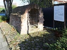
The Roman Eifel aqueduct , which supplied ancient Cologne with water, passes the local area to the east and has a large number of manholes that were used to maintain the pipeline. In 1979 and 1980, during the construction of the L165, a Roman building near the Eifel aqueduct and dating from the 1st to 3rd centuries AD, presumably a sewer maintenance facility, had to be archaeologically examined and preserved.
Breitenbenden was first mentioned in 1192 as "Breydenbent"; the place name is derived from the term broad meadow .
The St. Leonhards Chapel was built between 1871 and 1876.
On July 1, 1969, Breitenbenden was incorporated into Mechernich.
Culture and sights
Attractions:
- St. Leonhards Chapel
- Roman Eifel aqueduct
The long-distance cycle paths lead through the village:
- Eifel-Höhen-Route , which runs as a circular route around and through the Eifel National Park .
- Valley route , it opens up interesting tourist places in North Rhine-Westphalia on a family-friendly route.
Stations 14 to 17 of the Römerkanal hiking trail , which runs past Breitenbenden to the east, are located near the village.
traffic
The state road 115 runs through the village , on the outskirts the federal road 477 to Mechernich and the state road 165 as a feeder to the nearby federal highway 1 with the junction Bad Münstereifel / Mechernich.
Individual evidence
- ↑ Breitenbenden. City of Mechernich, June 30, 2017, accessed September 25, 2017 .
- ^ Klaus Grewe : Atlas of the Roman water pipes to Cologne. With contributions by Werner Brinker, Günther Garbrecht, Hansgerd Hellenkemper , Heinz-Otto Lamprecht, Horst D. Schulz , Edgar Thofern. (= Rhenish excavations. Volume 26. ). Rheinland-Verlag, Cologne 1986, ISBN 3-7927-0868-X , p. 79 ff .
- ^ Antonius Jürgens: Mechernich-Breitenbenden: Roman buildings. In: Heinz Günter Horn (Ed.): The Romans in North Rhine-Westphalia. Konrad Theiss Verlag, Stuttgart 1987, ISBN 3-8062-0312-1 , p. 541 ff.
- ↑ Hans Peter Schiffer: Churches and chapels in the deanery Mechernich. History, design, equipment. Kall 2003, p. 209 .
- ↑ Hans Peter Schiffer: Churches and chapels in the deanery Mechernich. History, design, equipment. Kall 2003, p. 210 .
- ↑ Martin Bünermann: The communities of the first reorganization program in North Rhine-Westphalia . Deutscher Gemeindeverlag, Cologne 1970, p. 100 .
- ↑ Klaus Grewe and Manfred Knauff: The long leadership of the Romans . The Römerkanal hiking trail Nettersheim-Cologne. Ed .: Eifelverein e. V. 2012, ISBN 978-3-921805-81-7 , pp. 167 ff .


