Full
|
Full
City of Mechernich
Coordinates: 50 ° 32 ′ 59 ″ N , 6 ° 38 ′ 49 ″ E
|
|
|---|---|
| Height : | approx. 330 m above sea level NHN |
| Residents : | 129 (April 4, 2010) |
| Postal code : | 53894 |
| Area code : | 02484 |
|
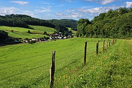
View of the full
|
|
Vollem is a district of Mechernich in the North Rhine-Westphalian district of Euskirchen .
geography
Vollem lies in the valley of the Veybach , which flows through the village, and on the county road 32, which runs through the valley. The next motorway junction is Bad Münstereifel / Mechernich on the A 1 .
history
Even the Romans built the Eifel aqueduct through the Veybach valley to supply water to ancient Cologne . A Roman aqueduct bridge can be visited in the southwest of the town . The small bridge was built to cross the Kallmuther Bach. It was exposed in 2008 and provided with a protective roof.
There is an old watermill in full. It was built around 1730 as a ban mill for the places Urfey, Vollem, Kallmuth, Lorbach and Keldenich. It is still fully functional today.
Individual evidence
- ^ Klaus Grewe : Atlas of the Roman water pipes to Cologne (= Rhenish excavations. Volume 26). With contributions by Werner Brinker, Günther Garbrecht, Hansgerd Hellenkemper , Heinz-Otto Lamprecht, Horst D. Schulz , Edgar Thofern. Rheinland-Verlag, Cologne 1986, ISBN 3-7927-0868-X , p. 64 ff.
- ↑ a b Michael Hamacher: Mills in the Fey Valley between Dreimühlen and Burgfey. The Feybach once drove 12 mills. In: District Euskirchen: Yearbook 2012. ISSN 1863-592X , p. 15 f.

