
Lückerath (Mechernich)
|
Lückerath
City of Mechernich
Coordinates: 50 ° 34 ′ 59 " N , 6 ° 35 ′ 4" E
|
|
|---|---|
| Height : | 317 m above sea level NHN |
| Residents : | 323 (Jan. 1, 2014) |
| Postal code : | 53894 |
| Area code : | 02443 |
 In the center of the village, in the ditch, the rivulet of the Schossbach stream
|
|
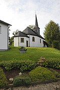
- St. Luzia


Lückerath is a district of Mechernich in the Eifel .
geography
Lückerath is a village that belongs to the city of Mechernich ( Euskirchen district ) in the south of North Rhine-Westphalia .
The Schoßbach flowing through the village has its headwaters about 1000 m southwest of the town center at the end of the elevated road and joins the Mühlenbach in the northeast of the town , which flows into the Erft near Dirmerzheim from the west . The Rot- und Bruchbachtal nature reserve lies north of the village .
The state road 169 running through the village connects the federal road 265 in Hergarten with the federal road 266 located in the south .
Neighboring villages are Schützendorf in the east, Bleibuir in the northwest and Denrath in the south.
Culture
- The "Lückerath Children's Fair" takes place every year on the 3rd Sunday of September and attracts thousands to the village on Schoßbach.
- Half-timbered ensembles worth seeing, a former half-timbered gymnasium serves as the village house
- Chapel of St. Luzia from 1718
- Lückerath has a primary school, the Catholic primary school Am Bleiberg .
Web links

Antweiler | Mountain | Bergbuir | Bergheim | Notification | Bleibuir | Breitenbenden | Denrath | Dreimühlen | Eicks | Eiserfey | Firmenich | Floisdorf | Go | Glehn | Harzheim | Hay cabin | Holzheim | Hostel | Kalenberg | Kallmuth | Katzvey | Kommern | Kommern-Süd | Lessenich | Lorbach | Lückerath | Mechernich | Obergartzem | Rissdorf | Roggendorf | Satzvey | Schaven | Schützendorf | Strempt | Urfey | Voissel | Full of | Vussem | Wachendorf | Hamlet on the mountains | Weißenbrunnen | Weyer | Wielspuetz