
Erft
|
Erft main line upper course: Kuhbach |
||
.png) Course of the Erft ( interactive map ) |
||
| Data | ||
| Water code | EN : 274 | |
| location |
Eastern Eifel
|
|
| River system | Rhine | |
| Drain over | Rhine → North Sea | |
| source | southeast of Engelgau as Kuhbach Erftquelle in Holzmülheim 50 ° 29 ′ 14 ″ N , 6 ° 41 ′ 14 ″ E |
|
| Source height | approx. 527 m above sea level NHN (main line upper course) Erftquelle: approx. 414 m above sea level NHN |
|
| muzzle | near Neuss - Grimlinghausen in the Rhine Coordinates: 51 ° 11 '4 " N , 6 ° 43' 54" E 51 ° 11 '4 " N , 6 ° 43' 54" E |
|
| Mouth height | approx. 31 m above sea level NHN | |
| Height difference | approx. 496 m | |
| Bottom slope | approx. 4.7 ‰ | |
| length | 106.6 km (including Kuhbach ) | |
| Catchment area | 1,837.915 km² | |
| Discharge at the Neubrück A Eo gauge: 1,595.43 km² Location: 9.75 km above the mouth |
NNQ (07/16/2007) MNQ 1970/2007 MQ 1970/2007 Mq 1970/2007 MHQ 1970/2007 HHQ (06/04/1984) |
5.15 m³ / s 10.4 m³ / s 16.4 m³ / s 10.3 l / (s km²) 31.3 m³ / s 46.6 m³ / s |
| Left tributaries | Veybach , Rotbach , Neffelbach | |
| Right tributaries | Swist , Gillbach , Norfbach | |
| Big cities | Neuss | |
| Medium-sized cities | Euskirchen , Erftstadt , Bedburg , Bergheim , Grevenbroich , Kerpen | |
| Small towns | Bad Münstereifel | |
 Lower course of the Erft near Bergheim |
||
 Erftquelle near Holzmülheim |
||
The Erft is a 106.6 km long, southwest and orographically left tributary of the Rhine . It flows through three districts and their respective district towns; Seen downstream, these are: District Euskirchen with Euskirchen , Rhein-Erft-Kreis with Bergheim and Rhein-Kreis Neuss with Neuss in North Rhine-Westphalia ( Germany ).
geography
course
The Erft rises at the northwestern edge of the Eifel belonging Ahr Hills in the Euskirchen district. Your kilometering begins southwest of the Frohngau district of Nettersheim at just under 527 m above sea level. NHN on the eastern slope of the Harzbüchel ( 537 m ). The Kuhbach is the source of the left upper course of the main strand, which flows south of the Himberg ( 549.6 m ). After 1.3 km of the upper course, a stream also called Kuhbach , also 1.3 km long and on the right-hand side, flows south across from Frohngau . The flowing water keeps the upper course name Kuhbach up to the further 2.4 km downstream in the Nettersheimer district Holzmülheim located Erftquelle (approx. 414 m ).
From there the Erft initially flows in a northeastern direction and then predominantly in a northerly direction. In the upper reaches, it first flows through the Eicherscheid flood retention basin and then through the town of Bad Münstereifel . Later it touches Euskirchen and Weilerswist , where it is crossed by the federal motorway 61 and then by the federal motorway 553 at the Bliesheim interchange .
North of Weilerswist it receives its largest tributary , the Swist , crosses under the Federal Motorway 1 and then flows along the A 61 via Kerpen - passing the Federal Motorway 4 east of the Kerpen junction - and Bergheim to Bedburg .

Before Grevenbroich , the Erft passes under the 540 federal motorway and reaches Neuss ; there, water is knocked off at a barrage from the Erft to the Obererft flowing into the Rhine . At Neuss it crosses under the federal highway 57 . Then the Erft joins the Rhine south of Düsseldorf's Josef-Kardinal-Frings-Brücke near Neuss-Grimlinghausen at a height of around 31 m . It was moved there in 1475 during the siege of Neuss by Charles the Bold of Burgundy.
Tributaries
|
Stat. in km |
Surname | GKZ | location | Length in km |
EZG in km² |
|---|---|---|---|---|---|
| 90.3 | Eschweiler Bach | 27414 | Left | 11,647 | 32,142 |
| 76.4 | Veybach | 27418 | Left | 22.879 | 84,924 |
| 73.3 | Kuchenheimer Mühlengraben | 274192 | right | 10.632 | 21.076 |
| 63.2 | Swist | 2742 | right | 43.658 | 289,408 |
| 55.8 | Rotbach | 2744 | Left | 39.215 | 236.265 |
| 53.6 | Liblarer Mühlengraben | 27454 | right | 10,329 | 39.126 |
| 46.7 | Neffelbach | 2746 | Left | 40.266 | 236.973 |
| 36.6 | Small Erft | 274732 | right | 12.784 | 35.283 |
| 32.3 | Finkelbach | 27474 | Left | 15,922 | 105.698 |
| 30.3 | Puetzbach | 274752 | Left | 11.101 | 33.673 |
| 5.3 | Gillbach | 2748 | right | 28,468 | 98.674 |
| 1.6 | Norfbach | 27494 | right | 19.867 | 105.691 |
Localities
At the Erft - source to mouth - are these localities ( viewed downstream ):
- Nettersheim -Holzmülheim
- Bad Münstereifel- Schönau
- Bad Münstereifel- Eicherscheid
- Bad Münstereifel
- Bad Münstereifel- Iversheim
- Bad Münstereifel- Arloff
- Bad Münstereifel- Kirspenich
- Euskirchen- Kreuzweingarten
- Euskirchen- Rheder
- Euskirchen- Stotzheim
- Euskirchen
- Euskirchen- Wüschheim
- Weilerswist- Bodenheim
- Weilerswist- Lommersum
- Weilerswist- Hausweiler
- Weilerswist- Vernich
- Weilerswist
- Erftstadt - Bliesheim
- Erftstadt- Liblar
- Erftstadt- Blessem
- Erftstadt- Dirmerzheim
- Erftstadt- Gymnich
- Kerpen- Brüggen
- Kerpen- Balkhausen
- Kerpen- Türnich
- Kerpen
- Kerpen- Horrem
- Bergheim- Quadrath-Ichendorf
- Bergheim
- Bergheim- Zieverich
- Bergheim- Thorr
- Bergheim- Paffendorf
- Bergheim- Glesch
- Bedburg
- Bedburg Kaster
- Bedburg- Broich
- Grevenbroich- Frimmersdorf
- Grevenbroich- Gustorf
- Grevenbroich- Neuenhausen
- Grevenbroich
- Grevenbroich- City of Wevelinghoven
- Grevenbroich chapels
- Grevenbroich city of Hülchrath
- Neuss- Holzheim-Minkel
- Neuss- Holzheim
- Neuss- Weckhoven
- Neuss- Selikum
- Neuss- Erfttal
- Neuss- Gnadental
- Neuss- Grimlinghausen
Water management

Between Türnich and Bedburg , the Erft is up to 20 meters wide in places. The river bed was relocated several times; it had to give way to mining in the Rhenish lignite area and was later straightened. The Erft became a water-rich river by feeding in the swamp water from lignite mining. In 1955 the Erft discharged 5 m 3 of water per second, between 1965 and 1975 over 26 m 3 of water. By relocating the Garzweiler opencast mine in the direction of Erkelenz , the swamp water will in future no longer be drained into the Erft, but will instead seep into the wetland of the Schwalm-Nette valley . As a result, the Erft will become a small river with a water flow of less than 3 m 3 of water per second and will change its appearance quite considerably. The Erftverband will remove the bank reinforcements on the island of Hombroich ( Neuss-Holzheim ) by 2015 so that the future Erft can look for a new bed. In the area of the Zubend in Wevelinghoven , old bedding beds from Roman times are widely included in the LVR's renaturation concept . The dismantling is to continue to Bedburg until 2045.
Neozoa and neophytes
Due to the warm water being discharged from the lignite industry into the Erft, introduced plant species such as the Brazilian thousand-leaf and the South American thick-leaved waterweed can survive here. Every year, 300 million cubic meters of warmed up groundwater (“swamp water”) from lignite mining are pumped into the Erft. In addition, there is the cooling water from the Frimmersdorf lignite power station. In winter the mean water temperatures are still 15 ° C and in summer 28 ° C. The middle course of the river is 8 ° C warmer than the upper course. The hot water is supplied below Erftstadt. As early as the 1990s, anglers reported three catches of piranhas , which, in contrast to the sunfish, could not form a reproductive population, but were merely released aquarium fish and probably only survived a few months. There are also guppies and red- eared tortoises in the Erft . For this reason, the BUND tried to stop the construction of the Neurath lignite power station.
Neozoa in the Erft:
|
Neophytes in the Erft:
|
see also: bioinvasion
history

The Erft was first mentioned in a document in the 7th century. It was initially called "Arnapa", later "Arnefe" and "Arlefe". Finally, in 1320, the name "Arfe" was found.

The city of Erftstadt was named after the river Erft in 1969 and the Erftkreis, which was newly formed on January 1, 1975 as part of the district reform , was renamed the Rhein-Erft district on November 1, 2003 ; also two railway lines, the Erftbahn ( Bedburg - Horrem ) and the Erfttalbahn (Euskirchen – Bad Münstereifel), as well as two regional transport lines, the Rhein-Erft-Express (RE 8) and the Rhein-Erft-Bahn (RB 27).
Worth seeing

Bad Münstereifel in the Erft valley
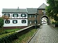
Aachener Tor in Bergheim , landmark of the Rhein-Erft district
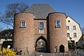
Erft gate in Bedburg- Kaster

Frimmersdorf power plant on canalised Erft

Erft near Neuss (2017)

Old and new estuary,
Tranchot map (1805)
Erft flood canal near Horrem


On the banks of the Erft there are, among other things, noteworthy castles , monasteries and palaces ( viewed downstream ):
- Hardtburg in Euskirchen-Stotzheim
- Türnich Castle in Kerpen-Türnich
- Hemmersbach Castle in Kerpen-Horrem
- Frens Castle near Bergheim-Quadrath
- Paffendorf Castle in Bergheim
- Bedburg Castle in Bedburg
- Grevenbroich Castle in Grevenbroich
- Wölkersburg in the city park in Grevenbroich-Wevelinghoven
- Wevelinghoven Castle in Grevenbroich-Wevelinghoven
- Old pastorate in Grevenbroich-Wevelinghoven
- Langwaden Abbey in Grevenbroich
- Hülchrath Castle in Grevenbroich-Hülchrath
- Reuschenberg Castle in Neuss-Selikum
Also:
- Museum Insel Hombroich in Neuss- Holzheim
- several moths and water mills
freetime and recreation
Well-developed cycle paths are laid out along the Erft , the 110 km long Erft cycle path runs from the source to the mouth.
The Erft is used by kayakers, a popular tour starts at the Erprather Mühle and leads over the Römerbrücke (kayak slalom route) to the Rhine.
Individual evidence
- ↑ a b German basic map 1: 5000
- ↑ a b c d e Topographical Information Management, Cologne District Government, Department GEObasis NRW ( information )
- ↑ Hydrological Yearbook 2007. ( Memento from August 9, 2014 in the Internet Archive ) (PDF, 360 kB)
- ↑ Map services of the Federal Agency for Nature Conservation ( information )
- ↑ Water directory of the State Office for Nature, Environment and Consumer Protection NRW 2010 (XLS; 4.67 MB) ( Notes )
- ↑ a b Tropical fish and plants make themselves comfortable in the rivers , on taz.de.
- ↑ Piranhas fished from the Rhine tributary , from January 31, 2007, on focus.de
- ↑ Piranhas and guppies: Exotics cavort in the Erft ( memento from October 3, 2009 in the Internet Archive ), from January 28, 2002, on vistaverde.de
- ↑ Piranhas soon also in the Rhine? ( Memento from September 15, 2012 in the web archive archive.today ), from July 24, 2009, on rp-online.de
- ↑ a b The Erft - a tropical river? ( Memento from June 8, 2010 in the Internet Archive ), on erftkanu.de
- ↑ Vallisneria spiralis L. (water screw, Hydrocharitaceae) ( Memento from August 11, 2013 in the Internet Archive ), on aquateophyten.de
- ↑ Excursion of the Bochum Botanical Association with a list of plants on August 29, 2015
literature
- Dirk Holterman, Harald Herzog: The Erft-Radweg, From the source to the mouth, Bouvier Verlag , Bonn, 2nd edition 2004, ISBN 3-416-03029-X .
- Dagmar Peters: Wanderlust an der Erft , Droste Verlag , Düsseldorf, 2015, ISBN 978-3-7700-1530-6 .
Web links
- Erftverband , on erftverband.de
- Erftradweg , on erftradweg.de
- Map / aerial photo of the course of the Erft