
Horrem (Kerpen)
|
Horror
City of Kerpen
|
||
|---|---|---|
 |
||
| Height : | approx. 80 m above sea level NHN | |
| Area : | 7.59 km² | |
| Residents : | 12,891 (Dec. 31, 2018) | |
| Population density : | 1,698 inhabitants / km² | |
| Incorporation : | 1st January 1975 | |
| Postal code : | 50169 | |
| Area code : | 02273 | |
Location of Horrem in North Rhine-Westphalia |
||

Horrem is a district of the city of Kerpen in the Rhein-Erft district in North Rhine-Westphalia on the eastern bank of the Erft . Until 1975 Horrem was an independent municipality.
geography
In the south is Götzenkirchen and in the east Neu-Bottenbroich , also districts of the city of Kerpen. Neighboring places are in the north Quadrath-Ichendorf (to Bergheim) and in the east Habbelrath (to Frechen).
history
Horror
Horrem was first mentioned in a document in 864 as Horoheim . During this time the settlement was described as belonging to the Kölngau . The old name of the place means something like swamp home . The name Horrem can also be derived from the Latin word "horreum" (granary) with good reasons. The Erft area was already known for its fertile loess soils in Roman times . After 18 years of service, Roman legion veterans were entitled to a farm post. These manors, Villae Rusticae, are documented for the Horrem area. The Roman legion in Cologne was supplied with grain from here, among other things.
In the 13th and 14th centuries, Horrem belonged to the Duchy of Jülich . From the 14th to the 17th century, the von Merode rulers of Hemmersbach Castle , that is, Horremer Unterherrschaft. The red posts of the Horrem coat of arms come from their coat of arms. 1789 Horrem was a place in the Jülich office Bergheim . After the occupation by the French troops, Horrem came to the canton of Kerpen in the Arrondissement of Cologne in the Département de la Roer . In Prussian times the municipality of Hemmersbach was established in the Bergheim district and was renamed Horrem in 1907 . The community initially belonged to the Sindorf mayor and from 1928 to the Sindorf office. In 1938 the name of the office was changed to Amt Horrem .
With the Cologne Act of 1974, Horrem has belonged to the city of Kerpen since January 1st, 1975.
Götzenkirchen
Up until the Napoleonic era the place was called Gutzenkirchen (from the name Godo or Götz) or Gotteskirchen; then the place names changed until it stayed with the current name. In the annals of the Historical Association for the Lower Rhine from 1912, "Churches of God" are mentioned. This name is also listed in the 1966 handbook of the Archdiocese of Cologne in brackets after the current name. In 1808 the parish in Götzenkirchen was subordinated to the Clemenskirche in Hemmersbach. The 20th World Youth Day took place in 2005 on the so-called "Marienfeld" in the adjacent former opencast mine, which is now a nature reserve.
coat of arms
The coat of arms of Horrem shows a lion with a blue anchor in its paws in a divided shield above in gold and four red posts on gold below.
traffic
rail
Deutsche Bahn and S-Bahn


The horrem station is a transportation hub in the Rhineland . It connects the route Cologne Hbf –Horrem– Düren - Langerwehe - Eschweiler Hbf - Aachen Hbf with the Erftbahn Horrem – Quadrath-Ichendorf – Bergheim – Bedburg – Grevenbroich– Düsseldorf Hbf . In addition, the S-Bahn S 12 Horrem – Cologne – Troisdorf – Siegburg – Hennef (Sieg) –Herchen – Au and S 13 / S 19 Düren – Horrem – Cologne – Cologne / Bonn Airport – Troisdorf (–Siegburg – Hennef (Sieg) –Herchen (–Au)). The NRW-Express RE 1 - the busiest train connection in Germany - also stops in Horrem, as does the Rhein-Sieg-Express RE 9. The tectonic shift of the Horremer Jump, which is part of the first jump, runs right through the station . With a view to small shifts, the rail joints of the S-Bahn and regional trains are mounted at this point so that they can be easily moved in the direction of travel. An elaborate underground bridge was built for high-speed traffic.
The station building was demolished in November 2012 and completely rebuilt. As part of a pilot project by Deutsche Bahn, the new station building was built as “Germany's first 'green station'” strictly according to ecological principles and equipped with environmentally friendly technology.
"North-South Railway" Rheinbraun
Another railway line runs along the eastern edge of Horrem. Coal and overburden are transported on this works railway line between the opencast mines and the coal-fired power stations of RWE Power (formerly Rheinbraun AG ). The Horrem Bridge was built in 1953/1954 at the point where this railway line crosses the Cologne – Aachen line operated by Deutsche Bahn . It became necessary because the electrification of the railway meant that the 1623 m long tunnel through the Ville had to be torn down - slit open. It was built in 1840 for the Belgium – Aachen – Cologne line.
The "strategic path"
The embankment of the "Strategic Railway" runs west of Horrem and Götzenkirchen . After 1870/71 this was supposed to connect the Rhine-Ruhr area through the Eifel with the Lorraine industrial area, which at that time belonged to the German Empire . In 1919 the Treaty of Versailles ended these plans. The bridge stumps near Ahrweiler and the “ government bunker ” near Dernau - Marienthal also belong to this unfinished railway line . The section from Horrem to Liblar was partly relocated after the Second World War because of lignite mining, but was closed shortly afterwards.
Assassination attempt in 1901
On November 28, 1901, at around 7 p.m., passenger train No. 640 from Verviers to Cologne Central Station derailed near Horrem station because a replaced old rail that was stored between the tracks had been laid across the track and fastened with wire . 4 dead, 3 seriously injured and 12 slightly injured were the result.
Street

Horrem is located directly at the Kerpen junction and can be reached via the Bergheim- Süd and Kerpen- Türnich exits (both A 61 ) and Kerpen / Sindorf / Horrem ( A 4 ). The A4 itself crosses Horrem in an east-west direction between Götzenkirchen and Horrem. The federal road 55 runs on the northern edge of the village .
In front of the station building there is a bus station with six platforms for the VRS omnibus routes in the direction of Bergheim, Bedburg, Elsdorf, Erftstadt, Frechen, Hüelte, Hürth , Kerpen, Königshoven and Sindorf .
The station forecourt and the bus station have been rebuilt and completely redesigned since 2010.
religion

The catholic parish association Horrem-Sindorf consists of the parishes "Christ the King" with the old parish church of Romanesque origin "St. Clemens" and the new parish church "Christ the King" in Horrem, " St. Cyriakus " in Götzenkirchen, "Holy Spirit" in Neu- Bottenbroich and "Sankt Maria Königin" as well as "Sankt Ulrich" in Sindorf.
The Protestant parish of Horrem with the Kreuzkirche am Mühlengraben in Horrem. The church and community center were dedicated in 1967.
There is also a New Apostolic Church and an Evangelical Free Church Congregation .
Horrem achieved worldwide fame through the visit of Pope Benedict XVI. as part of the World Youth Day 2005 on Marienfeld, east of Horrem .
The listed St. Cyriakus Church in Götzenkirchen is worth seeing .
education
In Horrem there are numerous kindergartens and two municipal primary schools - the Clemensschule and Rathausschule -, the municipal secondary school on Mühlengraben as well as the private secondary school Mater Salvatoris , the Adolf Kolping vocational college Horrem (technical center I - vocational college of the Rhein-Erft district) and the PRÄHA Education Center Horrem for Heilhilfsberufe gGmbH with the state-recognized vocational schools Anna-Hermann-Schule Kerpen and Präha Lehrinstitut für Physiotherapy . Since 2002, the internationally recognized Bachelor of Physiotherapy degree can be obtained there in the third year of training and an additional fourth year in Heerlen , Netherlands . The municipal secondary school and the Willy Brandt comprehensive school in Kerpen are located in the Horrem – Sindorf school center.
Attractions
Horror
Worth seeing are: the churches, especially the old St. Clemens Church, Hemmersbach Castle , the Salvatorian convent with adjoining secondary school (girls secondary school until 2016), the old town hall and the Pope's hill on Marienfeld . The previous building of Hemmersbach Castle, which was destroyed in 1366, is still recognizable as a "moth" on the southern edge of the village .

Hemmersbach Castle: gatehouse to the outer bailey

Hemmersbach Castle: Park


The Clemenskirche probably emerged from an own chapel of the Hemmersbach house. The medieval nave was significantly enlarged in 1852. The racing driver Wolfgang Graf Berghe von Trips lived at Hemmersbach Castle . A museum about him was located on the grounds of the castle until 2014, parts of the exhibition were transferred to the museum "Prototype - People. Force. Wagon." delivered in Hamburg. The first go- kart track in Germany, which had to make way for new residential buildings, was very close by . It was initiated by the "Renngrafen" von Trips, who got to know karting in the USA and introduced it in Germany. Michael Schumacher trained there as a child on the go-kart before the new kart track in Kerpen- Manheim was set up.
Götzenkirchen
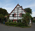
The ensemble of the old village street is characterized by small, mostly single-storey half-timbered houses.
The church of St. Cyriakus goes back to an original building of the 11th century. The current building is a simple baroque building. Because of the lowering of the groundwater level as a result of brown coal mining , Rheinbraun had to underpin the old foundations of the church; oil hydraulic pumps were installed to enable readjustment in the event of subsequent ground movements. The associated measuring points can be seen on the outside walls of the church.
House at Cyriakusstraße 40

House at Maurinplatz 1

Parish Church of St. Cyriacus

Crossroads on Cyriakusstrasse


literature
- See " Kerpen ".
- additionally:
- Helmut Weingarten: The railway between the Rhine and Erft. A reading book for railroad fans. Rheinland-Verlag, Cologne 1987, ISBN 3-7927-0973-2 , pp. 36-47 ( contributions to the history of the Erftkreis 5).
- Helmut Weingarten: The branches of the order of the 19th and 20th centuries. In: Erftkreis (ed.): Monasteries and monasteries in the Erftkreis. Rheinland-Verlag, Pulheim-Brauweiler 1988, ISBN 3-7927-1044-7 , p. 295: Salvatorian women ( contributions to the history of the Erftkreis 6 = Erftkreis publication 128).
- Susanne Harke-Schmidt, Franz Kretschmar: Hemmersbach Castle. Knight's seat, manor, Byteburg. Published by Claus Bachem. Bachem, Cologne 2002, ISBN 3-7616-1515-9 .
Web links
- Information about Horremer Bahnen
- Helmut Weingarten: Through the district at full speed
- Götzenkirchen
- Pastoral care area Horrem-Sindorf
Individual evidence
- ↑ Distribution to the districts in 2018. In: Website of the city of Kerpen. Retrieved February 9, 2019 .
- ↑ Martin Bünermann, Heinz Köstering: The communities and districts after the municipal territorial reform in North Rhine-Westphalia . Deutscher Gemeindeverlag, Cologne 1975, ISBN 3-555-30092-X .
- ↑ Germany's first climate-neutral station building for Kerpen-Horrem. DM Mobility Network Logistics, archived from the original on May 30, 2013 ; Retrieved October 7, 2013 . , VBR News-Net, Bahnaktuell
- ↑ Entry on the embankment of the strategic railway line from Neuss-Holzheim to Rommerskirchen in the database " KuLaDig " of the Rhineland Regional Association , accessed on July 16, 2017.
- ^ Ludwig Ritter von Stockert : Railway accidents. A contribution to railway operations theory. , Vol. 1. Leipzig 1913, p. 269, No. 197. Stockert does not provide any information as to whether the perpetrator or perpetrators could be identified.
- ↑ Bernd Imgrund , Nina Osmers : 111 places in the Cologne area that you have to see . Verlag Emons , Cologne 2010, ISBN 978-3-89705-777-7 , location 50.
Balkhausen | Blatzheim with Bergerhausen , Dorsfeld , Geilrath and Niederbolheim | Brüggen | Buir | Horrem | Langenich | Manheim | Manheim-new | Mödrath | Neu-Bottenbroich | Sindorf | Türnich