
Dernau
| coat of arms | Germany map | |
|---|---|---|

|
Coordinates: 50 ° 32 ' N , 7 ° 3' E |
|
| Basic data | ||
| State : | Rhineland-Palatinate | |
| County : | Ahrweiler | |
| Association municipality : | Altenahr | |
| Height : | 124 m above sea level NHN | |
| Area : | 5.72 km 2 | |
| Residents: | 1680 (Dec. 31, 2019) | |
| Population density : | 294 inhabitants per km 2 | |
| Postal code : | 53507 | |
| Primaries : | 02643 (Dernau) 02641 (Marienthal) |
|
| License plate : | AW | |
| Community key : | 07 1 31 017 | |
| LOCODE : | DE DEU | |
| Community structure: | 2 districts | |
| Association administration address: | Rossberg 3 53505 Altenahr, Germany |
|
| Website : | ||
| Local Mayor : | Alfred Sebastian | |
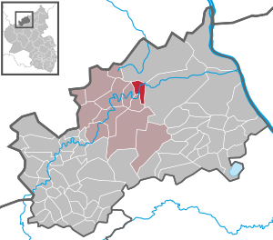
| Location of the local community of Dernau in the Ahrweiler district | ||
  |
||


Dernau an der Ahr is a municipality in the district of Ahrweiler in the north of Rhineland-Palatinate . Dernau belongs to the Altenahr community and is its second largest local community.
geography
Geographical location
Dernau lies in the Ahr Valley on the edge of the Ahr Mountains at approx. 125 m above sea level. NN , about 30 kilometers south of Bonn and 50 kilometers north of Koblenz . The highest elevation within the municipality is at 360 m above sea level. NN the Krausberg .
Neighboring communities
Dernau borders in a clockwise direction on the following communities, local communities and cities, starting in the north: Grafschaft , Bad Neuenahr-Ahrweiler , Rech and Mayschoss .
Community structure
A small part of the town of Marienthal to the east belongs to Dernau ; the greater part belongs to the city of Bad Neuenahr-Ahrweiler. Although Dernau has no official districts, it does have five so-called "Rotten", which emerged at the end of the 19th century and whose territories are precisely defined down to individual houses. Although there is a friendly relationship between the ranks, a certain local patriotism is always involved, for example in the village tournaments such as B. the donkey cup (soccer). The five groups are called “Baache”, “Haardte”, “Kiere”, “Ortesse” and “Patt Nocks”.
history
Roman times

The Romans already settled in the Ahr valley with its mild climate and from then on the settlement increased. At the foot of the vineyards facing south - for example from the cemetery to the upper village - there is a Roman layer of burns and broken glass. The main settlement area, however, was not far from the former winegrowers' association. During the construction of the cellars of the Dernau winegrowers' association in 1884 and on various other occasions, parts of a Roman courtyard ( villa rustica ) with hot water systems , mosaics, bathing facilities and a burial ground were exposed. There were coins found from the 3rd and 4th century AD.
After the end of the Roman era in 407, Dernau was first settled by the Alemanni and then by the Franks ( Ripuarer ). The old name of the place "Degerana" probably indicates the short period of settlement by Alemanni in the middle of the 5th century. The remains of two medieval moated castles with the associated moats could still be seen in the parcels "Im Graben" and "An der Burg" until the 1950s .
Middle Ages and Modern Times
Until 843 the entire area belonged to the Franconian Empire . According to the resolutions of the Treaty of Verdun , the so-called Middle Kingdom fell to Lothar I , who later gave the Lorraine region its name. Lothar I divided his Middle Kingdom to his descendants only 12 years later ( division of Prüm ). The middle area, which bordered from Friesland via the Rhineland to the Mediterranean, went to his son Lothar II.
The first documentary mention took place in 893 in the Prümer Urbar . In the Prüm list of goods this year a vineyard area was listed in "degernavale" or "degeneranauale" with an annual yield of three fuders of wine . This mention refers to the wine-growing town of Dernau, in whose area the Kesselinger Klosterhof in the climatically more favorable valley of the Ahr grew wine.
With the towns of Mayschoss and Rech, Dernau belonged to the rather small county of Saffenberg . In the course of its history, the eponymous Saffenburg changed hands frequently and has not been permanently inhabited since the 16th century . At the time of the Thirty Years' War , the Saffenburg was the scene of various witch trials .
After the witch hunters from Ahrweiler and Saffenburg were driven out by the Swedes in 1632, the villages of Dernau, Mayschoss and Rech were plundered by their troops.
Fifty years earlier (1588) Dernau had been plundered by the mercenaries of Martin Schenk von Nideggen during the time he was occupying Bonn.
The Saffenburg was destroyed in 1704 at the instigation of the Duke of Jülich in order to prevent mercenary troops from continuing to settle here in the future.
The Marienthal Monastery in the Dernau district was founded in 1136, plundered by the Swedish troops in 1632, and burned down by the Turenne troops in 1646 . Completely rebuilt in 1699, the monastery was abolished in 1802 under Napoleon as part of the secularization . In the last century it was part of a state viticulture domain . This state winery was taken over in 2004 by private local wineries and continued or expanded.
18th and 19th centuries
After 1792 the Ahr valley, like the entire left bank of the Rhine , was occupied and annexed by French revolutionary troops . From 1798 to 1814, Dernau was part of the canton of Ahrweiler , which in turn belonged to the arrondissement of Bonn in the French Rhine-Moselle department . During these two decades important foundations for today's form of viticulture were created. As a result of the agreements made at the Congress of Vienna , the entire previous Rhine-Moselle department fell to the Kingdom of Prussia in 1815 . Dernau was in 1816 the under Prussian administrative district Ahrweiler in Koblenz assigned, that of 1822 to the Rhine province belonged.
Dernau was particularly hard hit by the flood disaster of 1804. Two people drowned, two bridges, a house, three barns or stables and a forge were completely destroyed. 103 houses and just as many barns or stables were badly damaged.

From the 18th century to the middle of the 19th century there was a Jewish community in Dernau ; they made up about five percent of the total population. Jews from the surrounding communities visited the synagogue and the Jewish school in Teichgasse in Dernau. Six Jewish teachers are documented in Dernau from 1801 to 1847. According to the Prussian law of 1843 for the establishment of district synagogues, Dernau formed from around 1855 a. a. with Ahrweiler and Heimersheim a common synagogue community with Ahrweiler as the central point. Many of the Dernau Jews emigrated to Ahrweiler. In 1933, the proportion of the Jewish population in Dernau was not even one percent of the total population.
On September 17, 1880, the Ahr valley railway line with a terminus in Ahrweiler was opened. On December 1, 1886, the construction to Altenahr and on July 15, 1888 to Adenau was completed. This gave Dernau a connection to the left Rhine route , and with the completion of the Ludendorff Bridge in 1918/19 also to the right Rhine route.
20th century
From October 1943, as part of the underground relocation of war-important industries, five railway tunnels on the unfinished Neuss - Ahrtal railway line between Ahrweiler and Rech were rebuilt in order to manufacture components for V2 production with prisoners from the Rebstock satellite camp . While the Kuxberg tunnel was initially used as a production facility with a construction warehouse in the Hubachtal near Marienthal because of the higher coverage , it was planned to build a production line for V1 production in the Trotzenberg tunnel since July 1944 . This did not happen again, as the preparatory work was canceled in September 1944 due to internal disputes over competence between the Army (V2) and the Air Force (V1) and because the front was approaching. From September 2 to 27, 300 former Auschwitz prisoners who worked for the Volkswagen works in the V1 project were housed in two makeshift barracks near Dernau. After waiting two weeks for building materials, all 300 prisoners were brought to Mittelbau Dora in the Harz Mountains on September 21, 1944 , after they had dismantled the barracks. Since October 1944 tunnels in Dernau and Marienthal were used as air raid shelters for the population. Several weeks in the Hubachtal near Marienthal together with around 200 Buchenwald prisoners who had to dismantle the V2 production facilities there since September 1944 in order to bring them to Artern in the Harz Mountains. The last 100 or so prisoners from Buchenwald left the Hubach Valley and their accommodations there in the tunnel at the beginning of December 1944. From September to November 1944 a total of approx. 1000 workers (200 of them prisoners) were working for the V2 at Marienthal. From mid-August to mid-September 1944 approx. 600 workers (300 of them former Auschwitz prisoners, who were mentioned above) were on duty or on standby for the preparatory work for V1 production in Dernau.
In March 1945, US soldiers advancing as part of Operation Lumberjack blew up the tracks at Dernauer Bahnhof.
- Painting on the historical Dernau

Teichgasse around 1920

Kirchgasse around 1930
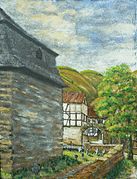
Old churchyard around 1926

Attending church in the winter of 1940

_ca._1920.JPG)

.JPG)
After the Second World War Dernau was in the French occupation zone . With the formation of the state of Rhineland-Palatinate in 1946, Dernau became a municipality in the Ahrweiler district . Subsequent considerations to annex the area of the lower and middle Ahr to North Rhine-Westphalia , as there are not only economic ties with the Bonn-Cologne area, were not implemented.
From 1960 to 1972 the so-called government bunker ("Marienthal Office") was built between Dernau and Ahrweiler . It should serve the constitutional organs from Bonn as a nuclear bomb-proof alternative seat in the event of a defense . After the end of the Cold War , the facility lost its strategic importance and became obsolete when the German government moved to Berlin . A small part of the extensive facility was opened to the public as of March 1, 2008 as the Cold War Museum . The rest of the bunker was gutted and locked.
politics
Municipal council
The municipal council in Dernau consists of 16 council members who were elected in a personalized proportional representation in the local elections in 2019 , and the honorary local mayor as chairman.
The distribution of seats in the municipal council:
| choice | CDU | FBL | total |
|---|---|---|---|
| 2019 | 7th | 9 | 16 seats |
| 2014 | 9 | 7th | 16 seats |
| 2009 | 10 | 6th | 16 seats |
| 2004 | 11 | 5 | 16 seats |
mayor
Alfred Sebastian became mayor of Dernau in 2009. In the direct election on May 26, 2019, he was confirmed in office for a further five years with 91.68% of the votes.
Culture and sights
Buildings


- Quarry stone bridge from 1717, rebuilt after 1804
- Old winegrowers' houses in the town center
- Old churchyard with basalt tombstones on the north side of the church
- Jewish cemetery Dernau an der Straße (K 35) to Grafschaft -Esch
- Krausberg Tower, built in 1927, blown up in 1944, reconstruction 1950 - 1967
- Parish Church of St. John the Apostle and Sylvester Chapel
- Government bunker in the Marienthal district or in Ahrweiler
- Former Augustinian monastery in Marienthal including church ruins
Regular events
Dernau organizes events that are known nationwide
- the Dernau wine spring - usually on the last weekend in April
- the winegrowers festival - four days on the last weekend in September
- the Martinsmarkt for regional delicacies - on the first or second weekend in November
Tourism, business and transport
tourism
According to the accommodation statistics of the State Statistical Office of Rhineland-Palatinate , the tourism sector in Dernau is growing faster than average. The change from a weekend excursion destination to a holiday resort is taking place. Numerous catering and accommodation businesses such as inns and restaurants are available to tourists. The offer of accommodation ranges from private rooms to guest houses and bed and breakfasts to simple hotels and complete holiday apartments. Next to the sports field there is a campsite and a mobile home parking space.
The Strauss taverns and the hut of the Eifelverein on the Krausberg next to the Krausberg tower offer easy refreshments .
Dernau is located on the route hiking trails Rotweinwanderweg , Ahrtalweg and AhrSteig and has several circular hiking trails such as the Krausbergrundweg . Krausbergturm (362 m above sea level) and Alfred Dahm tower (384 m above sea level) are among the hiking destinations. There is a small ski slope on the Krausberg.
economy
Dernau is the seat of the wine cooperative Weinmanufaktur Dagernova , founded over 140 years ago with 600 companies today. In the village there are numerous small businesses such as bicycle rentals, taxis, supermarkets, specialist trades, workshops, gas stations and a large number of wine-growing businesses.

Dernau is largely characterized by viticulture and, with 106 hectares of vineyards, is the second largest wine-growing community in the Ahr . Mainly red wine is grown. The individual layers of the municipality are:
- Dernauer Hardtberg, 30 hectares
- Dernauer Pfarrwingert, 10 hectares
- Dernauer Schieferlay, 21 hectares
- Dernauer Burggarten, 24 hectares
- Dernauer Goldkaul, 50 hectares
traffic

- The Dernau station is located on the Ahr Valley Railway Remagen - Ahrbrück , on which the "Rhein-Ahr-Bahn" (RB 30) runs every hour between Bonn Hbf and Ahrbrück. The "Ahr Valley Railway" (RB 39) runs between Remagen and Dernau is compressed every half hour.
- The tariff of the Verkehrsverbund Rhein-Mosel (VRM) applies to local public transport up to the state border , and that of the regional Verkehrsverbund Rhein-Sieg (VRS) across the country, and the NRW tariff for journeys throughout North Rhine-Westphalia . Local rail passenger transport (SPNV) is carried out by DB Regio NRW as part of the "Cologne Diesel Network", which uses "vareo" multiple units from Alstom Coradia LINT .
- Dernau is on the federal highway 267 , the so-called Ahr-Rotweinstraße , halfway between Altenahr and Bad Neuenahr-Ahrweiler.
Personalities
Born in Dernau
- Jacob Heymann (1746–1818), head of the synagogue in Dernau and a leading figure in Judaism in the Ahr valley at the time.
- Johann Josef Leyendecker (1810–1867), Paul Josef Leyendecker , Mathias Leyendecker (1821–1871)
- Peter Joseph Ley
- Willibald Näkel (1927–2004), local politician, mayor / local mayor from 1964 to 1984, holder of the Federal Cross of Merit, initiator of Ahr land consolidation and reconstruction, co-founder of the red wine trail in 1972 with brother Karl Näkel u. a., winemaker and restaurateur, owner of the Meyer-Näkel winery in the second generation, pioneer of dry Ahr red wine
- Wilhelm Josef Sebastian (* 1944), politician, member of the German Bundestag
- Werner Näkel (* 1953), German winemaker and owner of the Meyer-Näkel winery in Dernau
- Julia Baltes (* 1989), 64th German Wine Queen and co-owner of the Bertram – Baltes winery
Associated with Dernau
- Caius Iulius Peregrino 1st-2nd Century AD Roman citizen who lived in a villa rustica in Dernau with his wife Primia Camula . (Information from tombstone fragments from 1885)
- Martin Schenk von Nideggen (1540–1589), a military leader in the Dutch service, looted Dernau with his troops in 1587
- Stefan Leuer (1913–1979), architect and university professor, designed the observation tower on the Krausberg
- Björn Glasner (* 1973), German racing cyclist, active since 1978, professional 1996–2010
- Mandy Großgarten (* 1987), 62nd German Wine Queen
literature
- Matthias Bertram: underground relocation, Rebstock secret command, people and facts, culture of remembrance in Germany . Shaker-Media Verlag, Herzogenrath, 2018, ISBN 978-3-95631-656-2 .
Web links
- Official website of the community of Dernau
- History of the community of Dernau
- Floods in Dernau and their influence on the topography of the place
- Literature about Dernau in the Rhineland-Palatinate state bibliography
Individual evidence
- ↑ State Statistical Office of Rhineland-Palatinate - population status 2019, districts, communities, association communities ( help on this ).
- ↑ altenahr.de Info from VG Altenahr
- ↑ Flood disaster in the Ahr valley
- ↑ Receipt ( Memento of the original from April 27, 2015 in the Internet Archive ) Info: The archive link has been inserted automatically and has not yet been checked. Please check the original and archive link according to the instructions and then remove this notice.
- ^ The Regional Returning Officer Rhineland-Palatinate: Local elections 2019, city and municipal council elections
- ^ The Regional Returning Officer Rhineland-Palatinate: Municipal elections 2014, city and municipal council elections
- ↑ Alfred Sebastian this time without an opponent. In: Blick Aktuell. Krupp Verlags GmbH, Sinzig, May 5, 2014, accessed on August 4, 2020 .
- ^ The Regional Returning Officer Rhineland-Palatinate: direct elections 2019. see Altenahr, Verbandsgemeinde, sixth result line. Retrieved August 4, 2020 .
- ↑ Flood disaster in the Ahr valley
- ^ The artist family from Dernau and their successes in Paris between 1848 and 1871
- ↑ One of the first gold prospectors in California (from 1852; * 1827 Dernau; † 1865 Lewiston / Idaho) (PDF; 30.7 MB)

Cities: Adenau | Bad Breisig | Bad Neuenahr-Ahrweiler (seat of the district administration) | Niederzissen | Remagen | Sinzig
Municipalities: Ahrbrück | Altenahr | Antweiler | Aremberg | Barweiler | Bauler | Berg (near Ahrweiler) | Brenk | Brohl-Lützing | Burgbrohl | Dankerath | Dedenbach | Dernau | Dorsel | Dümpelfeld | Eichenbach | Fuchshofen | Galenberg | Glees | Gönnersdorf (near Bad Breisig) | County (Rhineland) | Harscheid (near Adenau) | Heckenbach | Herschbroich | Hoffeld (Eifel) | Hohenleimbach | Honerath | Hönningen | Bumblebee | Insul | Kalenborn (near Altenahr) | Kaltenborn | Kempenich | Kesseling | Kirchsahr | Königsfeld (Eifel) | Kottenborn | Leimbach (near Adenau) | Lind (near Altenahr) | Mayschoss | Meuspath | Müllenbach (near Adenau) | Müsch | Niederduerenbach | Nürburg | Oberduerenbach | Oberzissen | Ohlenhard | Pomster | Quiddelbach | Rech | Reifferscheid | Rodder | Schalkenbach | Guilt (Ahr) | Senscheid | Sierscheid | Spessart (Brohltal) | Trierscheid | Waldorf | Wassenach | Weir | Weibern (Eifel) | Wershofen | Wiesemscheid | Wimbach | Winnerath | Throws