
Königsfeld (Eifel)
| coat of arms | Germany map | |
|---|---|---|
_COA.svg)
|
Coordinates: 50 ° 30 ' N , 7 ° 11' E |
|
| Basic data | ||
| State : | Rhineland-Palatinate | |
| County : | Ahrweiler | |
| Association municipality : | Brohl valley | |
| Height : | 272 m above sea level NHN | |
| Area : | 7.2 km 2 | |
| Residents: | 689 (Dec. 31, 2019) | |
| Population density : | 96 inhabitants per km 2 | |
| Postal code : | 53426 | |
| Area code : | 02646 | |
| License plate : | AW | |
| Community key : | 07 1 31 041 | |
| Association administration address: | Kapellenstrasse 12 56651 Niederzissen |
|
| Website : | ||
| Local Mayor : | Werner Breuer ( CDU ) | |
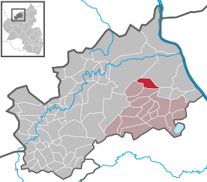
| Location of the local community of Königsfeld in the Ahrweiler district | ||
  |
||


Königsfeld is a municipality in the Ahrweiler district in Rhineland-Palatinate . It belongs to the Brohltal community , which has its administrative headquarters in Niederzissen .
geography
Königsfeld is located in the Vinxtbach valley. The residential areas Landgut Leyerhof and Ölmühle also belong to Königsfeld . The municipality is located in the conservation area "Rhein-Ahr-Eifel".
history
Königsfeld was first mentioned in a document on May 19, 992 when King Otto III. his faithful, the brothers Sigibodo and Richwin , who gave the Bannforst to "Cuningesvelt". On October 7, 1226, King Henry VII handed over the patronage rights of "Kuningsfelt" to the court of Sinzige . In a document from 1276 the place is called "Conixfelt". In 1335 the moated castle at "Cunisfelt" was first mentioned in a document. In 1336, Königsfeld was granted city rights and later even became the capital of the Königsfeld rulership , which included Königsfeld, Dedenbach and, at times, Schalkenbach and Vinxt . This rule, including the former moated castle in Königsfeld, belonged to the Imperial Knight von der Landskron and later (around 1700) to the Waldbott von Bassenheim . In 1784, the Königsfeld carpenters Philipp Zipp and Henrich Zipp played a key role in an attack on the village of Vinxt, which was part of the Landskron rulership and was transferred to the Duchy of Jülich in 1659 through an exchange of territory and, as part of this, to the Electoral Palatinate . The former mayor Hans-Josef Zipp comes from the same Zipp family.
In 1794 French revolutionary troops occupied the left bank of the Rhine . Under the French administration, Königsfeld was the main town ( chef-lieu ) of a mairie in the canton of Wehr , which was assigned to the arrondissement of Bonn and the Rhine-Mosel department . After the treaties concluded at the Congress of Vienna , the region, including Königsfeld, became part of the Kingdom of Prussia in 1815 . In 1816, Königsfeld became the seat of the mayor's office of the same name in the Ahrweiler district , which was part of the Coblenz administrative district and from 1822 to the Rhine Province . In 1930 the seat of the mayor's office, which had since been renamed "Amt" (1927), was relocated to Niederzissen .
The municipality has belonged to the state of Rhineland-Palatinate since 1946 and to the Brohlal community since 1969 .
- Population development
The development of the population of the municipality of Königsfeld, the values from 1871 to 1987 are based on censuses:
|
|
politics
Municipal council
The local council in Königsfeld consists of twelve council members, who were elected by a majority vote in the local elections on May 26, 2019 , and the honorary local mayor as chairman.
mayor
Werner Breuer became the local mayor of Königsfeld on June 1, 2016. Since there were no applicants for the direct election on May 26, 2019, the new election of the local mayor was incumbent on the council in accordance with municipal regulations. He confirmed Breuer, who originally no longer wanted to run for office, in his office on August 22, 2019.
Breuer's predecessor as local mayor, Hans-Josef Zipp (CDU), resigned from office at the end of May 2016 after 22 years in office.
Culture and sights
Attractions

_J%C3%BCdischer_Friedhof_186.JPG)
The parish church of St. Nicholas with its stately west tower dates back to the 13th century with its oldest components. Inside there is a Madonna from the first half of the 13th century. As early as 1226, King Heinrich VII transferred the rights of patronage over Königsfeld to Gerhard von Landskron . A model is exhibited in the church, which shows the former city with city wall and moated castle (demolished in 1830, the stones were used to build the old school building).
The closed village center with half-timbered houses and a Jewish cemetery on the edge of the forest are also worth seeing .
See also: List of cultural monuments in Königsfeld
Religions
The parish of Königsfeld includes Königsfeld, Dedenbach, Schalkenbach, Vinxt and Rodder in the Rhineland.
Surroundings
The Königsfeld area is ideal for hiking. The center of the village of Köngsfeld is the starting point of a “ceramic route”, a hiking trail that is adorned with many ceramic works of art and leads through a large part of the Vinxtbach valley.
Club life
Life in Königsfeld is characterized by a range of clubs. Young and old can meet at DJK Königsfeld e. V. Do sports. The teenagers and young adults have joined forces in the bachelor club, which also organizes the annual fair. Other important associations are the volunteer fire brigade, the St. Hubertus rifle club, the Künnisfelder Möhnen, Os Künnisfeld, the women's community, the church choir, the craftsmen's table and the Schwazz Bozze.
Web links
- Official website of the local community of Königsfeld
- City and rule of Königsfeld
- Königsfeld in the grip of the Waldbott von Bassenheim (with a picture from 1725, on which the moated castle, city wall and city gate can be seen)
- Literature about Königsfeld in the Rhineland-Palatinate State Bibliography
Individual evidence
- ↑ a b State Statistical Office of Rhineland-Palatinate - population status 2019, districts, municipalities, association communities ( help on this ).
- ↑ State Statistical Office Rhineland-Palatinate (ed.): Official directory of the municipalities and parts of the municipality. Status: January 2019 [ Version 2020 is available. ] . S. 9 (PDF; 3 MB).
- ^ Philipp de Lorenzi: Contributions to the history of all parishes in the Diocese of Trier , Bischöfliches General-Vicariate, 1887, p. 389 ( www.dilibri.de )
- ↑ State Statistical Office Rhineland-Palatinate - regional data
- ^ The Regional Returning Officer Rhineland-Palatinate: Local elections 2019, city and municipal council elections
- ↑ 12th meeting of the Königsfeld municipal council. In: Council and Citizen Information System. Verbandsgemeindeverwaltung Brohltal, May 23, 2016, accessed on August 3, 2020 .
- ↑ Hans-Josef Schneider: Königsfeld: Mayor Breuer stops. In: Rhein-Zeitung. Mittelrhein-Verlag GmbH, Koblenz, December 6, 2018, accessed on August 3, 2020 .
- ^ The Regional Returning Officer Rhineland-Palatinate: direct elections 2019. see Brohltal, Verbandsgemeinde, second line of results. Retrieved August 3, 2020 .
- ↑ CDU thanks Hans-Josef Zipp. In: Blick Aktuell. Krupp Verlags GmbH, Sinzig, June 25, 2016, accessed on August 3, 2020 .

Cities: Adenau | Bad Breisig | Bad Neuenahr-Ahrweiler (seat of the district administration) | Niederzissen | Remagen | Sinzig
Municipalities: Ahrbrück | Altenahr | Antweiler | Aremberg | Barweiler | Bauler | Berg (near Ahrweiler) | Brenk | Brohl-Lützing | Burgbrohl | Dankerath | Dedenbach | Dernau | Dorsel | Dümpelfeld | Eichenbach | Fuchshofen | Galenberg | Glees | Gönnersdorf (near Bad Breisig) | County (Rhineland) | Harscheid (near Adenau) | Heckenbach | Herschbroich | Hoffeld (Eifel) | Hohenleimbach | Honerath | Hönningen | Bumblebee | Insul | Kalenborn (near Altenahr) | Kaltenborn | Kempenich | Kesseling | Kirchsahr | Königsfeld (Eifel) | Kottenborn | Leimbach (near Adenau) | Lind (near Altenahr) | Mayschoss | Meuspath | Müllenbach (near Adenau) | Müsch | Niederduerenbach | Nürburg | Oberduerenbach | Oberzissen | Ohlenhard | Pomster | Quiddelbach | Rech | Reifferscheid | Rodder | Schalkenbach | Guilt (Ahr) | Senscheid | Sierscheid | Spessart (Brohltal) | Trierscheid | Waldorf | Wassenach | Weir | Weibern (Eifel) | Wershofen | Wiesemscheid | Wimbach | Winnerath | Throws