
Aremberg
| coat of arms | Germany map | |
|---|---|---|

|
Coordinates: 50 ° 25 ' N , 6 ° 49' E |
|
| Basic data | ||
| State : | Rhineland-Palatinate | |
| County : | Ahrweiler | |
| Association municipality : | Adenau | |
| Height : | 530 m above sea level NHN | |
| Area : | 9.62 km 2 | |
| Residents: | 218 (Dec. 31, 2019) | |
| Population density : | 23 inhabitants per km 2 | |
| Postal code : | 53533 | |
| Area code : | 02693 | |
| License plate : | AW | |
| Community key : | 07 1 31 005 | |
| LOCODE : | DE 6AT | |
| Association administration address: | Kirchstrasse 15 53518 Adenau |
|
| Website : | ||
| Local Mayor : | Alois Schneider | |
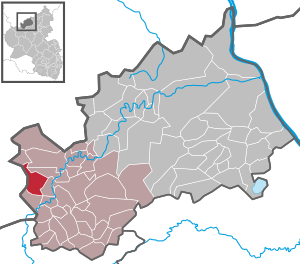
| Location of the local community Aremberg in the district of Ahrweiler | ||
  |
||


Aremberg is a municipality in the Ahrweiler district in Rhineland-Palatinate . It belongs to the Adenau community .
geography
Aremberg lies within the Ahr Mountains (Ahreifel) around 9.5 km (as the crow flies ) west-northwest of Adenau on the southwest flank of the 623 m above sea level. NHN high Arembergs between 510 and 560 m above sea level. NHN . The residential areas Forsthaus Gierscheid, Landgut Kapellenberg and Lenzenhof belong to Aremberg.
history
The first documentary mention of a "Henricus von Arberg" was in 1166.
- Population development
The development of the population, the values from 1871 to 1987 are based on censuses:
|
|
politics
Municipal council
The council in Aremberg consists of six council members, who in the local elections on May 26, 2019 in a majority vote were elected, and the honorary mayor as chairman.
mayor
In the direct election on May 26, 2019, Alois Schneider was confirmed in his office for another five years with 60.14% of the votes.
Infrastructure
The town's infrastructure has declined in recent years. In view of the high recreational value of the region and the planned closing of the gap on federal motorway 1 , the situation is expected to stabilize in the medium term.
The village has the Zur Burgschänke restaurant (a former school campus of the city of Duisburg), a community center and a school campus, which is jointly run by the Ernst-Moritz-Arndt-Gymnasium Bonn and the Friedrich-Ebert-Gymnasium Bonn .
Attractions
Sights include the ruins of the Höhenburg Aremberg, later Aremberg Castle, the ancestral seat of the Dukes of Aremberg , and the splendidly designed Catholic parish church of St. Nicholas . Local attractions include the 130 hectare large nature reserve Aremberg , in 1977 to protect the tertiary was established lava dome and the castle ruins.
Guardian Angel Chapel
The Guardian Angel Chapel was built in 1669 by the Guardian Angel Brotherhood founded by Pastor Lorenz Sprünker in the same year . The altar, which was built around 1670 and comes from the castle church in Croy (Belgium), was donated by the first Duke of Arenberg, Philipp-Franz . The inscription on the partition reads "Honor hikers the place of prayer for the holy guardian angel". The chapel was later extended by a porch. The sandstone blocks of the entrance arch come from the former ducal castle, the ruins of which are on the Aremberg. The chapel is still in use today and can be visited on Sundays in summer.
Traditions
The feast of St. The Trinity has a special place in the history of the parish of Aremberg. Many years ago, terrible storms caused great damage in the northern Eifel . As if by a miracle, the municipality of Aremberg was spared. While there was great need in the villages around afterwards, the Arembergers were able to support the poor.
In thanks for the protection of God, St. After the afternoon service, a procession to the guardian angel chapel to the station of the crucifixion of Christ, where the accompanying priest gives a blessing of bread. The blessed bread was given to the poor in earlier years. The establishment of the Trinity procession probably goes back to the founder of the Guardian Angel Brotherhood, Pastor Laurentius Sprüncker, who was pastor in Aremberg from 1663 to 1720.
Other traditions:
- Spring festival and fair. The bachelors organize a spring festival and the fair weekend every year. On these weekends, numerous residents and visitors from near and far gather to celebrate together with the bachelors in a warm atmosphere.
- Saint Martin
- Altar boy mulled wine sale
- Concerts in the parish church
leisure
Aremberg is a stage on the AhrSteige , which opened in November 2012 and leads from the source of the Ahr in Blankenheim to the confluence of the Ahr into the Rhine near Sinzig. The second stage, around 11.3 km long, begins at Freilinger See in Aremberg . At the same time, the third stage begins on site, which is 18.7 km long and goes to Insul . This leads over the Aremberg castle ruins and over the highest point of the Ahrsteige at 623 m .
Web links
- Internet presence of the local community Aremberg
- Literature about Aremberg in the Rhineland-Palatinate state bibliography
- Wilhelm Knippler: Aremberg im Dhall - houses and people in a dwarf residence. In: Heimatjahrbuch 1982. Ahrweiler district (historical representation of the Ahrweiler district).
- Eifel calendar for the year 1939, pp. 17-21 (H. Neu: The relations of Austria to the Eifel [with illustration of "Aremberg Castle after the destruction of 1803, in the state of 1820-1830"])
- Aremberg in the past and present . Warlich, Meckenheim 1987, ISBN 3-9800970-7-2
Individual evidence
- ↑ a b State Statistical Office of Rhineland-Palatinate - population status 2019, districts, municipalities, association communities ( help on this ).
- ↑ State Statistical Office Rhineland-Palatinate (ed.): Official directory of the municipalities and parts of the municipality. Status: January 2019 [ Version 2020 is available. ] . S. 5 (PDF; 3 MB).
- ↑ State Statistical Office Rhineland-Palatinate: My village, my city. Retrieved May 2, 2020 .
- ^ The Regional Returning Officer Rhineland-Palatinate: Local elections 2019, city and municipal council elections.
- ^ The Regional Returning Officer Rhineland-Palatinate: direct elections 2019. see Adenau, Verbandsgemeinde, third line of results. Retrieved August 6, 2020 .
- ↑ School camp - the last chapter. In: RP online. March 8, 2007, accessed May 2, 2020 .
- ^ Information board for the community at the chapel
- ↑ Information page of the Ahr Valley tourism about the Ahrsteig ( Memento from August 18, 2013 in the Internet Archive )

Cities: Adenau | Bad Breisig | Bad Neuenahr-Ahrweiler (seat of the district administration) | Niederzissen | Remagen | Sinzig
Municipalities: Ahrbrück | Altenahr | Antweiler | Aremberg | Barweiler | Bauler | Berg (near Ahrweiler) | Brenk | Brohl-Lützing | Burgbrohl | Dankerath | Dedenbach | Dernau | Dorsel | Dümpelfeld | Eichenbach | Fuchshofen | Galenberg | Glees | Gönnersdorf (near Bad Breisig) | County (Rhineland) | Harscheid (near Adenau) | Heckenbach | Herschbroich | Hoffeld (Eifel) | Hohenleimbach | Honerath | Hönningen | Bumblebee | Insul | Kalenborn (near Altenahr) | Kaltenborn | Kempenich | Kesseling | Kirchsahr | Königsfeld (Eifel) | Kottenborn | Leimbach (near Adenau) | Lind (near Altenahr) | Mayschoss | Meuspath | Müllenbach (near Adenau) | Müsch | Niederduerenbach | Nürburg | Oberduerenbach | Oberzissen | Ohlenhard | Pomster | Quiddelbach | Rech | Reifferscheid | Rodder | Schalkenbach | Guilt (Ahr) | Senscheid | Sierscheid | Spessart (Brohltal) | Trierscheid | Waldorf | Wassenach | Weir | Weibern (Eifel) | Wershofen | Wiesemscheid | Wimbach | Winnerath | Throws