
Aremberg (mountain)
| Aremberg | ||
|---|---|---|
 The Aremberg with the village Aremberg viewed from the direction of |
||
| height | 623.8 m above sea level NHN | |
| location | near Aremberg ; District of Ahrweiler , Rhineland-Palatinate ( Germany ) | |
| Mountains | Ahr Mountains (Ahreifel) | |
| Coordinates | 50 ° 25 '1 " N , 6 ° 48' 47" E | |
|
||
| Type | volcano | |
| rock | basalt | |
| Age of the rock | Tertiary | |
| particularities | Aremberg castle ruins with a lookout tower | |

The Aremberg is a tertiary volcano with 623.8 m above sea level. NHN the highest mountain in the Ahr Mountains (Ahreifel) . It is located near Aremberg in the Rhineland-Palatinate district of Ahrweiler . The Aremberg castle ruins with a lookout tower bear its basalt cone .
geography
location
The Aremberg rises in the north-western part of Rhineland-Palatinate around 2.25 km east of the border with North Rhine-Westphalia and belongs to the volcanic field of the Eastern Eifel . The village of Aremberg lies on its south-west slope , and the village of Antweiler at its south-eastern foot . A middle section of the Ahr flows past the mountain to the east, and to the north it is surrounded by the western Ahr tributary Eichenbach .
Natural allocation
The Aremberg belongs in the natural spatial main unit group Eastern Eifel (No. 27) and in the main unit Ahreifel (272) to the subunit Northern Ahrbergland (272.1), with its eastern flank in the subunit Middle Ahrtal (272.2) falling into the natural area Dümpelfelder Ahrtal (272.20).
Protected areas
The Aremberg nature reserve ( CDDA no. 81313; designated 1977; 1.3 km² in size) and the Aremberg fauna-flora-habitat area (FFH no. 5506-302; 2.41 km²) lie on a large part of the Aremberg region . There are also parts of him on protected landscape Rhein-Ahr-Eifel (CDDA No. 323834;. 1980 925.86 square kilometers) and the bird sanctuary Ahrgebirge (VSG No. 5507-401;. 304.23 square kilometers).
Aremberg castle ruins with a lookout tower
On the summit region of the Aremberg there are small remains of the Aremberg Castle, first mentioned in 1166, and in its former site a lookout tower built in 1854 out of ruins ( ⊙ ).
Nürburgring Nordschleife
The Aremberg race track section of the Nürburgring's Nordschleife , from which you can see the Aremberg, is named after the mountain.
Traffic and walking
East past the Aremberg leads in the valley Ahr between Fuchshofen and Antweiler the national road 73. From this road to the south of the mountain running branches in Antweiler county road 6 from that strikes south of the village Aremberg the K fifth The latter connects Dorsel through Aremberg with Eichenbach , to the east of it to meet the L 73. So you can drive around the mountain once and drive up to its high altitude in the village of Aremberg. For example, starting at these roads, the mountain can be hiked on forest paths and paths. A section of a Roman road runs north past the mountain .

Aremberg with the village of the same name, aerial photo (2014)

View from the Alendorfer Kalvarienberg northeast to the Aremberg

View from the sports field of a school camp over the village of Aremberg and the Aremberg
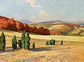
Juniper heather and Aremberg , painting by Fritz von Wille


Web links
Individual evidence
- ↑ a b Map service of the landscape information system of the Rhineland-Palatinate Nature Conservation Administration (LANIS map) ( notes )
- ↑ Map services of the Federal Agency for Nature Conservation ( information )