
Ahr
| Ahr | ||
 Course of the year |
||
| Data | ||
| Water code | EN : 2718 | |
| location | Germany | |
| River system | Rhine | |
| Drain over | Rhine → North Sea | |
| source | in the Ahr Mountains near Blankenheim 50 ° 26 '17 " N , 6 ° 38' 58" E |
|
| Source height | 474 m above sea level NHN | |
| muzzle | near Remagen - Kripp in the Rhine Coordinates: 50 ° 33 ′ 33 ″ N , 7 ° 16 ′ 36 ″ E 50 ° 33 ′ 33 ″ N , 7 ° 16 ′ 36 ″ E |
|
| Mouth height | 53 m above sea level NHN | |
| Height difference | 421 m | |
| Bottom slope | 4.9 ‰ | |
| length | 85.1 km | |
| Catchment area | 897.468 km² | |
| Discharge at the Altenahr A Eo gauge : 746 km² Location: 31.7 km above the mouth |
NNQ (1976) MNQ 1946-2007 MQ 1946-2007 Mq 1946-2007 MHQ 1946-2007 HHQ (1993) |
292 l / s 973 l / s 7.15 m³ / s 9.6 l / (s km²) 91.7 m³ / s 214 m³ / s |
| A Eo discharge : 897 km² at the mouth |
MQ Mq |
8 m³ / s 8.9 l / (s km²) |
| Medium-sized cities | Bad Neuenahr-Ahrweiler , Sinzig | |
| Communities | Blankenheim | |
| Navigable | Accessible by kayak and canoe | |
The Ahr (from Celtic aha for "water") is an 85.1 km long, western or left tributary of the Rhine in North Rhine-Westphalia and Rhineland-Palatinate ( Germany ).
geography
course
The Ahr has its source in the center of the Eifel located Blankenheim (Nordrhein-Westfalen) in the cellar of a half-timbered house in aggregated source at 474 m above sea level. NHN and then flows through the Schwanenweiher below Blankenheim Castle .
The south-east facing stream through the valley meadows of the upper Ahr valley, which is only moderately deepened into the Eifel heights and is largely under nature protection , is followed by federal road 258 . Below the district of Ahrdorf in the municipality of Blankenheim, the Ahr reaches its southernmost point and is in the Rhineland-Palatinate area. From Müsch via Antweiler to Fuchshofen , the river runs northwards and turns from Schuld via Insul to the east to Dümpelfeld . There the Ahr takes on the northeastern direction of flow of the Adenauer Bach, which joins from the right. At Altenahr, the valley bends to the east and initially has an unusually winding course. Here the river is accompanied by the B 267 , which does not follow every loop .
The largest loop in the Ahr begins in Altenahr ; it is under nature protection due to its flora and fauna. From here the valley is cut like a gorge with rugged rock slopes into the Ahr Mountains . From Reimerzhoven , viticulture is mainly carried out on the southern slopes north of the river, especially in the towns of Mayschoss , Rech , Dernau and Marienthal . The last bottleneck in the Ahr Valley lies below the Bunter Kuh , a rock formation that almost reaches the river and leaves little space for road and rail. In Walporzheim the valley widens suddenly and the Ahr crosses the district town of Bad Neuenahr-Ahrweiler . In Heimersheim the wine ends. The valley floor between Bad Bodendorf on the northern edge and Sinzig on a valley terrace in the south is characterized by arable farming and fruit and vegetable cultivation.
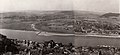
The mouth of the Ahr is located on the Golden Mile plain in the area of the city of Sinzig, near the adjacent Remagen district of Kripp , at around 53 m above sea level. NHN . Since the renaturation (from 1979, see aerial photos) it has been one of the few natural estuaries into the Rhine and has been designated as a nature reserve where the Ahr estuary .
- Pictures along the river

Ahrquelle (collected) in Blankenheim

Inscription at the source of the Ahr
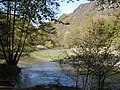
The Mittelahr below Altenahr with the rocks of the Langfig
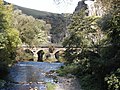
The Ahr at the Bunte Kuh rock formation near Walporzheim
The confluence of the Ahr and the Rhine before renaturation (around 1930)

The mouth of the Ahr after renaturation. On the right the village of Kripp


.jpg)

Tributaries
The tributaries on the left, over ten kilometers in length, are shown in dark blue, the ones on the right in light blue.
|
Stat. in km |
Surname | GKZ | location | Length in km |
EZG in km² |
Mouth Coordinates |
Mouth height in m above sea level NHN |
Source location Coordinates |
Source height in m above sea level NHN |
Remarks |
|---|---|---|---|---|---|---|---|---|---|---|
| 84.9 | Stegbach | 2718-1112 | right | 2.194 | Location ( Blankenheim ) | 473 | location | 542 | ||
| 84.2 | Ahr floodwater | 2718-1114 | right | 0.15 | Location (Blankenheim) | 442 | location | 445 | ||
| 83.1 | Mülheim Bach | 2718-112 | Left | 4,541 | 5,901 | location | 420 | location | 526 | |
| 82.5 | Nonnenbach | 2718-12 | right | 6,992 | 10,885 | location | 407 | location | 539 | |
| 81.9 | NN | 2718-1312 | right | 1.001 | location | 402 | location | 483 | ||
| 80.5 | Reetzer Bach | 2718-132 | Left | 3,585 | 3.558 | Location ( Reetz ) | 392 | location | 509 | |
| 79.2 | Schaafbach | 2718-14 | right | 11,422 | 28,031 | location | 378 | location | 581 | Source river: Eichholzbach |
| 78.2 | NN | 2718-152 | Left | 1,826 | location | 373 | location | 483 | ||
| 75.7 | Lampertsbach | 2718-16 | right | 9.48 | 28,071 | Location ( Dollendorf ) | 358 | Location ( Esch ) | 539 | Source river: Frömmelsbach |
| 74.6 | Fuhrbach | 2718-172 | right | 5.344 | 5.164 | Location ( Ahrhütte ) | 351 | Location ( Mirbach ) | 501 | also: Bechertstal |
| 74.0 | Mühlenbach | 2718-18 | Left | 7.106 | 16,172 | Location (Ahrhütte) | 348 | location | 490 | Source river: Weilerbach |
| 73.2 | Michelsbach | 2718-192 | right | 8.303 | 10.652 | Location ( Uedelhoven ) | 342 | location | 519 | |
| 72.9 | Aulbach | 2718-194 | Left | 5.08 | 5.055 | Location (Uedelhoven) | 341 | location | 524 | |
| 71.1 | Willemsbach | 2718-1992 | right | 1.356 | Location (Uedelhoven) | 341 | Location (Uedelhoven) | 450 | ||
| 70.7 | Göttersbach | 2718-1994 | right | 1.012 | Location (Uedelhoven) | 340 | Location (Uedelhoven) | 395 | ||
| 68.8 | Ahbach | 2718-2 | right | 14,866 | 90,958 | Location ( Ahrdorf ) | 331 | Location ( Betteldorf ) | 559 | |
| 66.0 | Herresbach | 2718-36 | Left | 3.2956 | 3,776 | Location ( Dorsel ) | 304 | location | 432 | |
| 64.2 | Trierbach | 2718-4 | right | 25.274 | 116.194 | Location ( Müsch ) | 294 | location | 614 | |
| 61.1 | Huhnenbach | 2718-52 | Left | 4,349 | 5.154 | Location ( Antweiler ) | 281 | location | 486 | |
| 60.3 | Limbach | 2718-532 | right | 3,928 | 3.68 | Location (Antweiler) | 277 | Location ( Reifferscheid ) | 460 | |
| 58.7 | Eichenbach | 2718-534 | Left | 6,934 | 7.173 | location | 273 | Location ( Lommersdorf ) | 528 | Source river: Hirzenfin soaps |
| 55.5 | Laufenbach | 2718-536 | right | 2.758 | 4.07 | Location ( Fuchshofen ) | 258 | Location (Reifferscheid) | 432 | |
| 55.4 | Dreisbach | 2718-54 | Left | 10.03 | 16,392 | Location (Fuchshofen) | 256 | location | 507 | |
| 52.0 | Armuthsbach | 2718-56 | Left | 18,353 | 60.526 | Location ( fault ) | 245 | location | 531 | |
| 49.8 | NN | 2718-5712 | Left | 0.896 | Location (fault) | 232 | Location ( Harscheid ) | 417 | ||
| 47.9 | Wood soaps | 2718-574 | Left | 0.996 | 0.549 | location | 223 | location | 348 | |
| 47.5 | Atzenbach | 2718-576 | right | 2.522 | 2.36 | location | 222 | Location ( Winnerath ) | 432 | |
| 46.6 | Welsbach | 2718-5792 | right | 1.281 | Location ( insul ) | 218 | location | 399 | ||
| 45.3 | Lückenbach | 2718-58 | right | 5.677 | 6.62 | location | 212 | Location ( Lückenbach ) | 294 | |
| 44.7 | Adenauerbach | 2718-6 | right | 15.719 | 58.473 | Location ( Dümpelfeld ) | 209 | location | 533 | Source river: Breitscheider Bach |
| 44.6 | Burgheckbach | 2718-712 | right | 0.566 | 0.759 | Location (Dümpelfeld) | 209 | location | 207 | also: Wingertsbach |
| 43.6 | Ommelbach | 2718-714 | right | 1.928 | 1.934 | Location ( Liers ) | 205 | location | 319 | |
| 42.8 | Liersbach | 2718-72 | Left | 14,463 | 28,936 | Location (Liers) | 201 | location | 529 | |
| 40.5 | Digging in the wide field | 2718-732 | right | 0.63 | 0.496 | location | 198 | location | 289 | |
| 38.4 | Kesselinger Bach | 2718-74 | right | 14,142 | 95.013 | Location ( Ahrbrück ) | 184 | Location ( Schelborn ) | 509 | also: Staffeler Bach |
| 38.3 | Steinbach | 2718-76 | Left | 2.469 | 1.401 | Location ( Brück ) | 184 | location | 363 | |
| 38.2 | Bach vom Schorling | 2718-78 | Left | 2,456 | 3.174 | Location (Brück) | 184 | location | 332 | also: Mirbach |
| 35.2 | Breidertbach | 2718-794 | Left | 1.044 | 0.713 | location | 174 | location | 332 | |
| 35.3 | Kreuzberger Graben | 2718-798 | Left | 0.814 | 0.726 | Location ( Kreuzberg ) | 169 | location | 172 | |
| 34.0 | Sahrbach | 2718-8 | Left | 15.308 | 46.072 | Location (Kreuzberg) | 171 | location | 384 | |
| 33.9 | Vischelbach | 2718-92 | Left | 10,539 | 18.671 | Location (Kreuzberg) | 171 | location | 374 | |
| 31.5 | Bach from the Burtscheiderberg | 2718-932 | Left | 2.219 | 5.216 | Location ( Altenahr ) | 157 | location | 303 | also: Rossbach |
| 22.0 | Brook at the Sonnenheck | 2718-934 | right | 1.568 | 1,777 | Position ( computing ) | 127 | location | 352 | also: Young Berren or Bärenbach |
| 21.9 | Nollbach | 2718-94 | right | 1,768 | 2,394 | Location (right) | 127 | location | 306 | also: Donnenbach |
| 20.2 | Steinbergsbach | 2718-95114 | right | 1.046 | 1,480 | Location (right) | 122 | location | 252 | Estuary over Mühlgraben? |
| 18.3 | Kratzenbach | 2718-9512 | Left | 1,921 | 3.238 | Location ( Marienthal ) | 116 | location | 229 | also: climate protection pond |
| 16.8 | Heckenbach | 2718-952 | right | 2,425 | 3.391 | Location ( Walporzheim ) | 116 | location | 356 | also: Geusbach (upper course) |
| 15.1 | Wingsbach | 2718-96 | right | 4,509 | 5.378 | Location ( Ahrweiler ) | 105 | location | 372 | |
| 14.5 | Mill pond ditch | 2718-9712 | Left | 0.174 | 0.012 | Location ( Bad Neuenahr ) | 102 | location | 106 | Outflow of the Giesemer Bach |
| 12.9 | Bachemer Bach | 2718-972 | right | 6,961 | 8,394 | Location (Bad Neuenahr) | 96 | location | 397 | |
| 11.4 | Fuchsbach | 2718-974 | Left | 4,437 | 9,072 | Location (Bad Neuenahr) | 92 | location | 255 | Upper course according to DGK: Lantershofener Bach or Töschenbach |
| 9.6 | Mill pond | 2718-9752 | right | 2.029 | 2.123 | Location (Bad Neuenahr) | 85 | location | 84 | |
| 9.2 | Idienbach | 2718-976 | right | 5.305 | 5.073 | Location ( Heimersheim ) | 84 | location | 342 | |
| 8.7 | Leimersdorfer Bach | 2718-98 | Left | 8.520 | 27.984 | Location ( Heppingen ) | 81 | location | 215 | |
| 7.0 | Mühlenbach | 2718-9912 | right | 2,383 | 5,799 | Location ( Lohrsdorf ) | 74 | location | 84 | also: mill pond |
| 6.9 | Lohrsdorfer Bach | 2718-992 | Left | 2.502 | 2.935 | Location (Lohrsdorf) | 74 | location | 135 | |
| 3.8 | Mühlenbach | 2718-9954 | Left | 3.852 | 4,484 | Location ( Sinzig ) | 62 | location | 65 | |
| 3.1 | Hellenbach | 2718-996 | right | 7.672 | 11,707 | Location (Sinzig) | 60 | location | 291 | |
| 2.5 | Harbach | 2718-998 | right | 9,921 | 14.24 | Location (Sinzig) | 58 | location | 258 |
Notes on the table
- ↑ Water code number , in Germany the official river code number with a separator inserted after the prefix for better readability, which stands for the common receiving water Ahr .
- ↑ a b c d e estuary data from GeoExplorer of the Rhineland-Palatinate water management authority ( notes ) (the estuary is not recognizable on the German base map 1: 5000)
Data
The Ahrquelle has an average bulk of 12 liters of water per second. The spring water contains many nitrogenous ions such as ammonium and nitrate .
The Ahr and its tributaries are the central water system , belonging to the East Eifel Ahr Hills . It drains a catchment area of 897.468 km². At the estuary, the Ahr reaches an average water flow of 8 m³ / s.
Of the 85.1 km total length of the Ahr, around 17 km flow into North Rhine-Westphalia and around 68 km into Rhineland-Palatinate. The river has a bed gradient of 0.4 percent in the lower course and 0.4 to 0.8% in the upper course .
Flood
The Ahr reached deadly high water levels with destructive effects in 1804 (64 dead) and 1910 (57 dead). As a result, all Ahr bridges - with the exception of the one at Rech - had to be rebuilt in the 20th century. In the Ahrstrasse tunnel in Altenahr there are marks of the highest levels.
On June 2, 2016, the Ahr level in Kreuzberg and Altenahr reached its highest level since measurements began. At the Altenahr gauge, the Ahr rose to 369 centimeters, 20 cm more than the highest flood to date in 1993.
history
There were isolated settlements in the Ahr Valley as early as Roman times , as evidenced by the Roman villa in Bad Neuenahr-Ahrweiler as Villa Rustica on the Silberberg. Due to its originally unfavorable traffic situation, the Ahr valley was , however, only densely populated relatively late - at least as far as the middle and upper reaches were concerned. That changed around the middle of the 19th century. The expansion of the settlements, the traffic routes (three different railway lines, such as the Ahr Valley Railway , were gradually built into the valley) and the agricultural areas in the Ahr Valley resulted in the river bed becoming more and more narrow. The course of the river has been straightened and its banks paved. Weirs were built in the river in order to be able to supply mills and irrigation systems evenly with water . Artificial bed sills should reduce the flow velocity and thereby prevent erosion .
However, weirs and bed sills have been dismantled for a number of years with the aim of improving water ecology. As part of the “ Salmon 2000 ” funding program , attempts have been made for several years to reintroduce salmon and sea trout to the Ahr.
Wine-growing area
The Ahr is known for the vineyards in the Ahr Valley from the local community of Altenahr downstream. The Ahr wine-growing region is the largest closed red wine-growing region in Germany. The red wine hiking trail leads through the southern slopes of the lower Ahr valley and passes the government bunker documentation site above the river valley near Ahrweiler .
Ahr cycle path
In 2007 the Ahr cycle path between Remagen-Kripp and Blankenheim was completed. It has a length of 85 kilometers and above Dümpelfeld mainly follows the route of the Middle and Upper Ahr Valley Railway, which has been disused in this section . The bike path is well developed and signposted.
literature
- Gottfried Kinkel: The guide through the Ahrthal together with a description of the cities of Linz, Remagen and Sinzig. T. Habicht, Bonn 1849, (digitized version)
- The Ahr valley (= Stollfuss hiking map. No. 9). Map 1: 50,000. Stollfuss, Bonn no year (around 1950).
- Gottfried Kinkel : The Ahr (= Rheinisches Land. Small series ). With panels by Theo Felten. Georg Fischer, Wittlich 1953.
- Matthias Röcke: Castles and palaces between Ahr and Brohlbach. Famous and unknown systems in the Ahrweiler district. Bachem, Cologne 1984, ISBN 3-7616-0751-2 .
- Michael Losse: Theiss Castle Guide Hohe Eifel and Ahrtal. 57 castles and palaces. Theiss, Stuttgart 2003, ISBN 3-8062-1775-0 .
- Vera Kettenbach: The Ahr Valley. From Bad Bodendorf to Altenahr. Gaasterland, Düsseldorf 2004, ISBN 3-935873-02-6 .
- Achim Gaasterland (Ed.): AhrtalReise. A vacation magazine for the region. Wine & culinary arts, nature & landscape, culture & fitness. Gaasterland-Verlag, Düsseldorf 2007, ISBN 978-3-935873-18-5 .
- Christoph Lüttgen: Red Wine Hiking Trail. Gaasterland-Verlag, Düsseldorf 2008, ISBN 978-3-935873-23-9 .
- Literature about the Ahr in the catalog of the German National Library
References and comments
- ^ German basic map 1: 5000.
- ↑ a b Map service of the landscape information system of the Rhineland-Palatinate Nature Conservation Administration (LANIS map) ( notes )
- ↑ a b c Water directory of the State Office for Nature, Environment and Consumer Protection NRW 2010 (XLS; 4.67 MB) ( Notes )
- ↑ a b c d e f g h i j k l m n o p q r s t u v w x GeoExplorer of the Rhineland-Palatinate water management authority ( information )
- ↑ Altenahr Ahr gauge , level data from the Rhineland-Palatinate State Office for the Environment (LfU)
- ↑ a b Federal Agency for Nature Conservation: Ahr estuary. Restoration of a river delta. on bfn.de (PDF; 174.7 kB)
- ↑ Legal ordinance on the nature reserve "Muzzle of the Ahr". (PDF; 91.7 kB) Ahrweiler district, June 23, 1981, accessed on January 2, 2014 .
- ↑ Bottom slope: difference in height of a current or in the sewer system
- ↑ Petra Ochs: When the Ahr brought death and devastation. (PDF) June 18, 2014, accessed April 12, 2017 .
- ↑ Record flood on the Ahr , from June 2, 2016, on wetteronline.de
Web links
- Nature reserve "Obere Ahr with Mühlheimer Bach, Reetzer Bach and Mühlenbachsystem" in the specialist information system of the State Office for Nature, Environment and Consumer Protection in North Rhine-Westphalia
- Map / aerial photo of the course of the Ahr
- What's new In: History and stories from the Ahr valley…. on ahr-eifel-rhein.de
- Flood. In: History and stories from the Ahr valley…. on ahr-eifel-rhein.de
- Ahr. (AW-Wiki of the Ahrweiler district), on aw-wiki.de
- Ahr river and wine landscape. on ahrxwein.de
- Working group for the protection of the Ahr , on arge-ahr.de
- The red wine hiking trail along the Ahr valley. (and other Ahr hiking trails), on ahr-rotweinwanderweg.de
- Ahr 2000 (nature conservation project), on ahr-2000.de
- Rough ramp gives salmon a chance. (Article about the dismantling ofbarrages and bed slidein the Ahr as well as the reintroduction of salmon and sea trout ), on wir-in-bad-bodendorf.de
- Where the black and blue ant blue lives. (Article about flora , fauna and renaturation of the Ahrmuende nature reserve), on wir-in-bad-bodendorf.de
- Barbara and Hans Otzen: The Ahr. Landscape - history - culture - wine. 2010, on bouvier-verlag.de (PDF; 4.18 MB)
- The Ahr: Life on the river. In: Rhein-Zeitung . Dossier, on rhein-zeitung.de