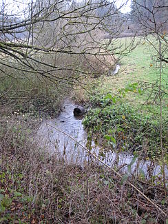
Lampertsbach (Ahr)
|
Lampertsbach Frömmelsbach (upper reaches to Alendorf ) |
||
|
Lampertsbach before stream shrinkage |
||
| Data | ||
| Water code | DE : 271816 | |
| location | Eifel , Vulkaneifel district , Euskirchen , Rhineland-Palatinate , North Rhine-Westphalia ( Germany ) | |
| River system | Rhine | |
| Drain over | Ahr → Rhine → North Sea | |
| source | east of Esch in the Vulkaneifel district 50 ° 21 ′ 31 ″ N , 6 ° 37 ′ 0 ″ E |
|
| Source height | approx. 539 m above sea level NHN | |
| muzzle | between Hüngersdorf and Dollendorf in the Ahr Coordinates: 50 ° 23 '26 " N , 6 ° 43' 10" E 50 ° 23 '26 " N , 6 ° 43' 10" E |
|
| Mouth height | approx. 358 m above sea level NHN | |
| Height difference | approx. 181 m | |
| Bottom slope | approx. 19 ‰ | |
| length | 9.5 km | |
| Catchment area | 28.071 km² | |
| Communities | Esch , Blankenheim with the districts of Alendorf and Hüngersdorf | |
|
Lampertstal west of the mouth of the Wierstaler Bach |
||
The Lampertsbach ( also called Frömmelsbach up to Alendorf ) is an approximately 9.5 km long, western and right tributary of the Ahr in the Rhineland-Palatinate district of Vulkaneifel and in the North Rhine-Westphalian district of Euskirchen .
geography
course
The Lampertsbach has its source in the Ahreifel as Frömmelsbach . The source is located east of Esch in Rhineland-Palatinate at an altitude of around 539 m .
From here the stream flows in an easterly direction and soon passes the border to North Rhine-Westphalia . It flows through the nature reserve Lampertstal and Alendorfer Kalktrifte with Fuhrbach and Mackental in the area of the municipality Blankenheim . From the mouth of the Odenbach (km 7.6) near Alendorf , where the creek passes the Kalvarienberg ( 522.8 m ), it is called Lampertsbach. As such, it flows northeast through the Lamperstal and flows east of Hüngersdorf and north of Dollendorf at an altitude of about 358 m into the Rhine tributary Ahr coming there from the north-west .
Catchment area and tributaries
The 28,071 km² catchment area is drained to the North Sea via the Ahr and Rhine .
|
Stat. in km |
Surname | GKZ | location | Length in km |
EZG in km² |
Mouth | Mouth height in m above sea level NHN |
|---|---|---|---|---|---|---|---|
| 7.6 | Odenbach | 271816-18 | Left | 5.340 | 2,880 | Alendorf | 454 |
| 6.6 | Rohrtaler Bach | 271816-192 | Left | 1,499 | ? | Alendorf | 434 |
| 6.5 | Wammesbach | 271816-32 | right | 4.304 | 6.496 | 432 | |
| 5.2 | Mirbach | 271816-4 | right | 3.953 | 5.383 | 413 | |
| 3.0 | Wierstaler Bach | 271816-92 | Left | 2.637 | ? | 389 |
Notes on the table
- ↑ Water code number , in Germany the official river code number with a separator inserted after the prefix for better readability, which stands uniformly for the Lampertsbach receiving water that is common to all .
- ↑ In the GeoExplorer of the Rhineland-Palatinate Water Management Authority ( notes ), the Wammesbach is given as the source river of the Lampertsbach, not the Frömmelsbach, so the waterway indicators also differ.
Others
The Lampertsbach has a special feature: a so-called stream shrinkage . The subsoil under a bridge is so rugged that a large part of the water flows downwards. When the water level is low, the stream "disappears" completely.
Web links
Individual evidence
- ↑ Map service of the landscape information system of the Rhineland-Palatinate nature conservation administration (LANIS map) ( notes )
- ↑ a b c German basic map 1: 5000
- ↑ a b c Water directory of the State Office for Nature, Environment and Consumer Protection NRW 2010 (XLS; 4.67 MB) ( Notes )
- ^ "Lampertstal and Alendorfer Kalktriften" nature reserve in the specialist information system of the State Office for Nature, Environment and Consumer Protection in North Rhine-Westphalia
- ↑ Topographical Information Management, Cologne District Government, Department GEObasis NRW ( Notes )
- ↑ Nature experience in the Euskirchen district


