Ahreifel
| Ahreifel | |||
|---|---|---|---|
| The Aremberg, the highest elevation in the Ahreifel | |||
| Systematics according to | Handbook of the natural spatial structure of Germany | ||
| Greater region 1st order | Low mountain range threshold | ||
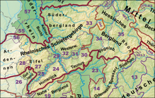
| Greater region 2nd order | 24, 25, 27–33, 344, 56 → Rheinisches Schiefergebirge |
||
| Main unit group | 27 → Eastern Eifel |
||
| 4th order region (main unit) |
272 → Ahreifel |
||
| Geographical location | |||
| Coordinates | 50 ° 27 '0 " N , 6 ° 53' 0" E | ||
|
|||
| state | North Rhine-Westphalia , Rhineland-Palatinate | ||
The Ahreifel is a natural area in the northeast of the Eifel . It includes the middle Ahr valley as well as the Ahr mountains north and the high altitudes south of it. It lies on both sides of the border between North Rhine-Westphalia and Rhineland-Palatinate
location
The Ahreifel lies between the municipality of Blankenheim in the west and the cities of Bad Münstereifel in the north, Ahrweiler in the east and Adenau in the south. It includes the Ahr valley from Antweiler in the west to Ahrweiler in the east. In North Rhine-Westphalia, all areas of the Ahreifel belong to the city of Bad Münstereifel in the Euskirchen district . In Rhineland-Palatinate, the Ahreifel region belongs to the municipalities of Adenau and Altenahr and the city of Bad Neuenahr-Ahrweiler , all in the Ahrweiler district .
Natural structure
In the manual of the natural division of Germany , the Ahreifel forms the main unit 272 and belongs to the main unit group 27 Eastern Eifel . It is further subdivided as follows:
- 272 Ahreifel
- 272.0 Reifferscheider mountain country
- 272.1 Northern Ahrbergland
- 272.2 Middle Ahr Valley
- 272.20 Dümpelfelder Ahr Valley
- 272.21 Research Ahrengtal
- 272.3 Southern Ahrbergland
places
Adenau in the south, right on the border with the Hocheifel , is the only town whose city center is in the Ahreifel region. Otherwise the settlement is characterized by small to medium-sized villages . In the Ahr valley you can find Antweiler, Schuld , Liers , Hönningen , Ahrbrück , Altenahr , Mayschoss and Dernau, among others . North of the Ahr in North Rhine-Westphalia you can find the southern elevations of the urban area of Bad Münstereifel with the Mutscheid , Rupperath , Mahlberg , Effelsberg and Houverath . The municipalities of Hümmel , Wershofen , Lind and Kalenborn are located in Rhineland-Palatinate . Rodder , Reifferscheid , Niederadenau , Kesseling and Ramersbach can also be found south of the Ahr in Rhineland-Palatinate .
Individual evidence
- ↑ E. Meynen , J. Schmithüsen u. a .: Handbook of the natural spatial structure of Germany . Federal Institute for Regional Studies, Remagen / Bad Godesberg 1953–1962 (9 deliveries in 8 books, updated map, M = 1: 1,000,000 with main units 1960).
- ^ Ewald Glässer: Geographical land survey: The natural space units on sheet 122/123 Cologne / Aachen. Federal Institute for Regional Studies, Bad Godesberg 1978. → Online map (PDF; 8.7 MB)
- ↑ Heinz Fischer, Richard Graafen: Geographical land survey: The natural space units on sheet 136/137 Cochem. Federal Institute for Regional Studies, Bad Godesberg 1974. → Online map (PDF; 5.6 MB)

