Rodder
| coat of arms | Germany map | |
|---|---|---|

|
Coordinates: 50 ° 24 ' N , 6 ° 52' E |
|
| Basic data | ||
| State : | Rhineland-Palatinate | |
| County : | Ahrweiler | |
| Association municipality : | Adenau | |
| Height : | 440 m above sea level NHN | |
| Area : | 6.38 km 2 | |
| Residents: | 239 (Dec. 31, 2019) | |
| Population density : | 37 inhabitants per km 2 | |
| Postal code : | 53520 | |
| Area code : | 02693 | |
| License plate : | AW | |
| Community key : | 07 1 31 072 | |
| Association administration address: | Kirchstrasse 15 53518 Adenau |
|
| Website : | ||
| Local Mayor : | Thomas Youngling | |
| Location of the local community Rodder in the Ahrweiler district | ||
Rodder is a municipality in the Ahrweiler district in Rhineland-Palatinate . It belongs to the Adenau community .
geography
Geographical location
Rodder is located near Adenau in the Eifel, away from major thoroughfares and relatively remote in the Vulkaneifel . Neighboring communities are Reifferscheid in the north-west, Honerath in the south-west, Werft in the south, Müsch in the south-west and Antweiler in the north-west. The development is in the midst of fields, which in turn are enclosed by extensive forest areas.
The Waldhof residential area also belongs to Rodder .
climate
The annual precipitation is 719 mm. The precipitation is in the middle third of the values recorded in Germany. Lower values are registered at 44% of the measuring stations of the German Weather Service . The driest month is February, with the most rainfall in June. In June there is 1.5 times more rainfall than in February. Precipitation varies only minimally and is extremely evenly distributed over the year. Lower seasonal fluctuations are recorded at only two percent of the measuring stations .
history
Rodder was first mentioned in documents in 975, when the place was owned by the Trier Abbey of St. Maximin . Until the end of the 18th century it belonged to the electoral office of Nürburg and to the mayor office of Reifferscheid . In the plague epidemic in 1667, almost the entire population of the place died.
Under French administration, Rodder belonged to the canton of Adenau in the Rhine-Moselle department . As a result of the resolutions at the Congress of Vienna in 1815, the left bank of the Rhine , including Rodder, was assigned to the Kingdom of Prussia . After the administrative structure newly created by Prussia, Rodder belonged to the mayor's office of Adenau in the Adenau district from 1816 , which was assigned to the Koblenz administrative district in the Rhine province (1822). Rodder has been part of the state of Rhineland-Palatinate since 1946 .
The fire disaster of 1857 destroyed 13 buildings including their stables.
- Statistics on population development
The development of the population of Oberlascheid, the values from 1871 to 1987 are based on censuses:
|
|
politics
Municipal council
The council in Rodder consists of six council members, who in the local elections on May 26, 2019 in a majority vote were elected, and the honorary mayor as chairman.
mayor
Thomas Jüngling became the local mayor of Rodder on July 12, 2019. Since there was no candidate in the direct election on May 26, 2019, the upcoming election of the mayor was incumbent on the council, which decided in favor of young people, in accordance with the municipal regulations.
The youth's predecessor as mayor was Peter Meyer.
coat of arms
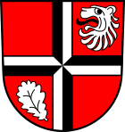
| Blazon : “In the red head of the shield a black and silver carved cross. In the upper left part of the shield a silver lion head and in the lower right part of the shield a silver oak leaf. " | |
| Founding of the coat of arms: Until 1290, the Nürburg counts, as rulers, had sovereignty over the village. The lion head depicted in the coat of arms is therefore the silver lion of the Counts of Nürburg. After that, from 1356 onwards, it was the Archbishops of Cologne who held the electoral dignity. These created the same-named Electoral Cologne Office from the Nürburg County. For this, the Rodderers also performed their haulage services and paid taxes from the income from the logging. Within the office, Rodder belonged to the Reifferscheid mayor's office. The cross in the coat of arms is therefore the black cross of the Electorate of Cologne. When the French revolutionary troops marched in, Kurköln was abolished. Rodder now belonged to the Mairie (mayor's office) Adenau, in the arrondissement of Bonn, Rhine-Moselle department of Koblenz. In addition to agriculture, the forest has always been the economic basis of the village. The oak, from the wood of which the half-timbered houses were built that have survived the centuries, deserves a special mention. |
Culture and sights
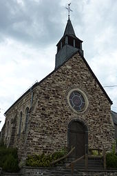
- The St. Roch chapel from 1903
- Annual fair or parish fair is celebrated on the Sunday before August 16 (Rochus).
- Old half-timbered houses
See also: List of cultural monuments in Rodder
Web links
- Literature about Rodder in the Rhineland-Palatinate State Bibliography
Individual evidence
- ↑ State Statistical Office of Rhineland-Palatinate - population status 2019, districts, communities, association communities ( help on this ).
- ↑ State Statistical Office Rhineland-Palatinate (ed.): Official directory of the municipalities and parts of the municipality. Status: January 2019 [ Version 2020 is available. ] . S. 7 (PDF; 3 MB).
- ↑ State Statistical Office Rhineland-Palatinate - regional data
- ^ The Regional Returning Officer Rhineland-Palatinate: Local elections 2019, city and municipal council elections
- ^ The Regional Returning Officer Rhineland-Palatinate: direct elections 2019. see Adenau, Verbandsgemeinde, 27th line of results. Retrieved August 9, 2020 .
- ↑ Peter Meyer: Announcement of the results of the election to the local council of the local community Rodder on May 26, 2019 (PDF; 8.1 KB) Verbandsgemeinde Adenau, June 3, 2019, accessed on August 9, 2020 .
- ↑ Description of coat of arms / justification. Rodder parish, accessed August 1, 2017 .


