
Right
| coat of arms | Germany map | |
|---|---|---|

|
Coordinates: 50 ° 31 ' N , 7 ° 2' E |
|
| Basic data | ||
| State : | Rhineland-Palatinate | |
| County : | Ahrweiler | |
| Association municipality : | Altenahr | |
| Height : | 284 m above sea level NHN | |
| Area : | 4.69 km 2 | |
| Residents: | 564 (Dec. 31, 2019) | |
| Population density : | 120 inhabitants per km 2 | |
| Postal code : | 53506 | |
| Area code : | 02643 | |
| License plate : | AW | |
| Community key : | 07 1 31 068 | |
| LOCODE : | DE RE5 | |
| Association administration address: | Rossberg 3 53505 Altenahr, Germany |
|
| Website : | ||
| Local Mayor : | Dominik Gieler ( CDU ) | |
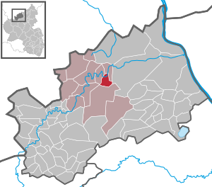
| Location of the local community Rech in the district of Ahrweiler | ||
  |
||

.png)

Rech is a municipality in the Ahrweiler district in the north of Rhineland-Palatinate . It belongs to the community of Altenahr .
geography
Computing is on the south bank of the Ahr at the foot of Mount Steiner, one of the higher mountains of the Ahr Hills , about 30 kilometers south of Bonn and 50 kilometers northwest of Koblenz .
Right borders the following communities in a clockwise direction, starting in the north: Dernau , Kesseling and Mayschoss .
history
- 1408: First documentary mention (in the registers of the Princes of Metternich)
- 1482: Rech comes to rule Saffenberg
- 1704: Destruction of the Saffenburg
- 1720: Construction of the Church of St. Luzia
- 1723: Start of construction work on the stone Ahr bridge
- 1910: The stone bridge is the only bridge to survive the great flood
- Population development
The development of the population of the municipality of Rech, the values from 1871 to 1987 are based on censuses:
|
|
politics
Municipal council
The municipal council in Rech consists of twelve council members who were elected by a majority vote in the local elections on May 26, 2019 , and the honorary local mayor as chairman.
The distribution of seats in the municipal council:
| choice | SPD | CDU | FWG | UBL | total |
|---|---|---|---|---|---|
| 2019 | by majority vote | 12 seats | |||
| 2014 | 3 | 7th | - | 2 | 12 seats |
| 2009 | 3 | 5 | 2 | 2 | 12 seats |
| 2004 | 3 | 7th | 2 | - | 12 seats |
- UBL = Independent Citizens' List Rech
mayor
Dominik Gieler (CDU) became local mayor of Rech on July 1, 2019. In the direct election on May 26, 2019, he was elected for five years with 84.76% of the vote.
Gieler's predecessor Hans-Dieter Kutscher (SPD) had held the office for 20 years, but did not start again in 2019.
Culture and sights
Buildings
In Rech, the Nepomuk Bridge is the oldest surviving Ahr bridge , which was the only one to survive the great flood of 1910. The Nepomuk Bridge was completely renovated in 2008.
The old winery , the oldest half-timbered house in Rech from the 17th century.
See also: List of cultural monuments in Rech
Regular events
- Three-day wine festival on the third weekend in September
- Lucia market on the second weekend of Advent
- Culinary vine hiking days on the last weekend in April
Economy and Infrastructure
Tourism and retail
Rech has two hotels and several private and semi-commercial accommodation providers. The tourism sector has been declining significantly since 2013, which led to the closure of several accommodation establishments and almost all retail stores.
Viticulture
Computing is part of the wine field Walporzheim in the region Ahr . There are 20 larger wine-growing businesses in the village, and the area under vines is 35 hectares . About 81% of the wine grown are red wine grape varieties (as of 2010). In 1979 there were still 54 farms operating, the vineyard area at that time was 48 hectares.
- Vineyards
traffic

- The Rech stop is located on the originally double-track Ahr Valley Railway ( Remagen - Ahrbrück ), on which the Rhein-Ahr-Bahn (RB 30) operates for local rail passenger transport .
- Local rail passenger transport is carried out by DB Regio NRW , which uses DB class 643 diesel multiple units for the Rhein-Ahr-Bahn for speeds of up to 120 km / h.
- The tariff of the Verkehrsverbund Rhein-Mosel (VRM) and the Verkehrsverbund Rhein-Sieg (VRS) as well as the NRW tariff apply to public transport on the Rhein-Ahr-Bahn .
- The federal highway 267 runs through Rech .
- Between Mayschoss and Rech (as between Dernau and Walporzheim), the Ahr Cycle Path runs as a partial railway cycle path on the route of the former northern second track of the Ahr Valley Railway, between Altenahr and Walporzheim together through two tunnels and over seven Ahr bridges.
- On the western outskirts of Rech, the Liblar - Rech section of the unfinished Ruhr-Mosel-Relief Strategic Railway was to be bundled with the Ahr Valley Railway. Several tunnel portals in the vineyards and the stumps of the Adenbach Viaduct near Ahrweiler are evidence of it today . There the disused " government bunker" was built, including two tunnels of the "unfinished" (-> Silberberg , Kuxberg tunnel ).
Personalities
- Ovo Maltine (born April 16, 1966 in Rech; † February 8, 2005 in Berlin), politician and cabaret girl
Web links
- Official website of the local parish Rech
- Literature on computing in the Rhineland-Palatinate Landesbibliographie
Individual evidence
- ↑ a b State Statistical Office of Rhineland-Palatinate - population status 2019, districts, municipalities, association communities ( help on this ).
- ↑ a b State Statistical Office Rhineland-Palatinate - regional data
- ^ The Regional Returning Officer Rhineland-Palatinate: Local elections 2019, city and municipal council elections
- ↑ Constituent meeting of the local council of the local community Rech. In: Rats- und Bürgerinformationssystem. Verbandsgemeinde Altenahr, July 1, 2019, accessed on August 5, 2020 .
- ^ The Regional Returning Officer Rhineland-Palatinate: direct elections 2019. see Altenahr, Verbandsgemeinde, last line of results. Retrieved August 5, 2020 .
- ^ Günther Schmitt: Change of the mayor after 20 years in Rech. In: General-Anzeiger. General-Anzeiger Bonn GmbH, July 3, 2019, accessed on August 5, 2020 .

Cities: Adenau | Bad Breisig | Bad Neuenahr-Ahrweiler (seat of the district administration) | Niederzissen | Remagen | Sinzig
Municipalities: Ahrbrück | Altenahr | Antweiler | Aremberg | Barweiler | Bauler | Berg (near Ahrweiler) | Brenk | Brohl-Lützing | Burgbrohl | Dankerath | Dedenbach | Dernau | Dorsel | Dümpelfeld | Eichenbach | Fuchshofen | Galenberg | Glees | Gönnersdorf (near Bad Breisig) | County (Rhineland) | Harscheid (near Adenau) | Heckenbach | Herschbroich | Hoffeld (Eifel) | Hohenleimbach | Honerath | Hönningen | Bumblebee | Insul | Kalenborn (near Altenahr) | Kaltenborn | Kempenich | Kesseling | Kirchsahr | Königsfeld (Eifel) | Kottenborn | Leimbach (near Adenau) | Lind (near Altenahr) | Mayschoss | Meuspath | Müllenbach (near Adenau) | Müsch | Niederduerenbach | Nürburg | Oberduerenbach | Oberzissen | Ohlenhard | Pomster | Quiddelbach | Rech | Reifferscheid | Rodder | Schalkenbach | Guilt (Ahr) | Senscheid | Sierscheid | Spessart (Brohltal) | Trierscheid | Waldorf | Wassenach | Weir | Weibern (Eifel) | Wershofen | Wiesemscheid | Wimbach | Winnerath | Throws