Galenberg
| coat of arms | Germany map | |
|---|---|---|

|
Coordinates: 50 ° 26 ' N , 7 ° 11' E |
|
| Basic data | ||
| State : | Rhineland-Palatinate | |
| County : | Ahrweiler | |
| Association municipality : | Brohl valley | |
| Height : | 345 m above sea level NHN | |
| Area : | 2.28 km 2 | |
| Residents: | 209 (Dec. 31, 2019) | |
| Population density : | 92 inhabitants per km 2 | |
| Postal code : | 56651 | |
| Area code : | 02655 | |
| License plate : | AW | |
| Community key : | 07 1 31 204 | |
| Association administration address: | Kapellenstrasse 12 56651 Niederzissen |
|
| Website : | ||
| Local Mayor : | Reinhold Schmitz | |
| Location of the local community of Galenberg in the Ahrweiler district | ||
Galenberg is a municipality in the Ahrweiler district in Rhineland-Palatinate . It belongs to the Brohltal community , which has its administrative headquarters in Niederzissen .
Geographical location
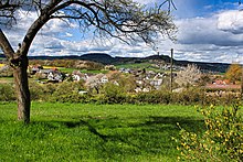
Galenberg situated on a hill (about 300- 480 m above sea level. NHN ), about three kilometers southwest of Niederzissen . To the west is the Engeler Kopf, the Brenker Schellkopf and behind that the Bockshahn near Spessart. In the northwest, the Perlkopf towers over the hilly landscape. On the right in front of it are the grove and the Olbrück castle ruins, on or on the Phonolithkopf, shaped as a saddle mountain . To the right follow Oberdürenbach , Büschhöfe and the Königsee, as well as Niederdürenbach and the Rodder Maar . In the north is Oberzissen with the Marienköpfchen. In the northeast and east follow Niederzissen with the volcanic cone of Bausenberg, the remains of Herschenberg, Ober- and Niederlützingen .
history
Place name
To explain the place name, it can be read in the local history that Stephan Weidenbach tries to interpret the name Galenberg in his publication 'Die Ortsnames im Kreis Mayen' (1901/1902). So it would be attributed to those names composed of 'munt' or 'mont' = mountain. In connection with the Celtic 'kal' = 'to be hard', Galenberg then means 'hard mountain'. This would also give a plausible explanation for the very difficult to work earth. There is a well-known saying that "Galenberg is extremely rich". But there are other interpretations as well. So the Celtic 'Gal' indicates the presence of water; Without water, settlements in the early days were unthinkable. There have always been several sources south of the location 'Im Seifen', but they have disappeared in the course of the land consolidation process carried out in 1980. Many people think the place name could refer to a former gallows. However, this cannot be proven historically. Since the influence of the French (1794–1815), the name Gallenberg can also be found on old maps .
First documentary mention
The first documentary mention is on November 25, 1275. On that day a certain Giselbert von Galinberg was present as a witness to a contract being signed in the Laach monastery . Here the Count of Virneburg sold a farm to Kell to the monastery.
Local history
In Roman times, a Roman road ran in the area from Mayen to Sinzig. A Roman estate was discovered in 1887 not far from the western boundary of the district. The place belonged from the beginning to the year 1794 to the rule Olbrück , which originated around the year 1050. The Lords of Olbrück owned some forests, fields and meadows here.
From a list from 1544, which was created to collect the so-called Turkish tax for the places Galenberg and Brechtingen (the name for Brenk at the time ), some house names can still be derived today. A document from 1643, which is comparable to a land register, shows that a total of 68 acres of arable land, 17 acres of meadows and 2 acres of vineyards were cultivated at that time.
After 1794 Galenberg belonged politically to the Mairie Wehr in the canton of Wehr and in the arrondissement of Bonn in the Rhine-Mosel department . In 1815, due to the resolutions of the Congress of Vienna , the region came under the control of the Kingdom of Prussia , and Galenberg came under the administration of the Burgbrohl mayor in the Mayen district .
Ecclesiastically, the place still belongs to the parish of Wehr and the diocese of Trier .
Population development
The development of the population of Galenberg, the values from 1871 to 1987 are based on censuses:
|
|
politics
Municipal council
The municipal council in Galenberg consists of six council members, who were elected by a majority vote in the local elections on May 26, 2019 , and the honorary local mayor as chairman.
mayor
Community leader or mayor
- 1920–1929: Johann Porz
- 1929–1946: Jakob Schmitt
- 1946–1948: Heinrich Schumacher
- 1948–1969: Heinrich Porz
- 1969–1999: Rochus Porz
- 1999–2014: Reinhold Schmitz
- 2014–2019: Bernd Esten
- since 2019: Reinhold Schmitz
In the direct election on May 26, 2019, Reinhold Schmitz was elected for five years with 60.16% of the vote.
coat of arms
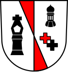
The red stand, reduced to two compartments, is derived from the twelve-fold red and silver coat of arms of Baron Waldbott von Bassenheim , Herren zur Olbrück . The tailor's cross commemorates a victim of the Olbrück rule. The church tower is the listed onion dome of the St. Rochus Chapel. The two crosses below symbolize the secular affiliation to the Electorate of Cologne (black cross) and the clerical affiliation to the Archdiocese of Trier (red cross).
Culture and sights
Attractions
- The St. Rochus Chapel from 1729 was expanded from 1954 and has been partially renovated since then. Your onion dome is a listed building . See the list of cultural monuments in Galenberg
- Village square with fountain in the center of the village; the half-timbered building comes from an old farm with a forge and is now used as fire department accommodation.
- The tailor's cross is a stone memorial cross from 1612 that commemorates the murder of a tailor by the lords of Burg Olbrück , from the Waldbott von Bassenheim family at that time .
societies
There is a volunteer fire brigade, a football club and a Möhnen club in the village. The fire brigade organizes a village festival every two years (on Pentecost). FC 'Starkstrom' has been organizing the St. Rochus fair (August 16) for years and the Möhnen (founded in 2006) are in control of the carnival. All three associations get involved either alone or together on other occasions (e.g. Martinsfeuer, Nikolausfeier, etc.).
Economy and Infrastructure
Hunting association
The Galenberg hunting area covers around 228 hectares. Although this is actually a small game hunt, roe deer, deer and wild boar can also be hunted. The annual hunting lease has been administered by the hunting association for around 150 years .
Hiking trails
In the southeast of the Galenberg district, two main hiking trails of the Eifelverein cross , namely the Jakobsweg from Bonn to Moselkern and the Vulkanweg from Andernach to Gerolstein .
Web links
- Wolfgang Dietz: The Rochus Chapel in Galenberg
- Wolfgang Dietz: The tailor's cross from Galenberg
- Local community Galenberg on the website of the Association of Brohltal
- Literature about Galenberg in the Rhineland-Palatinate State Bibliography
Individual evidence
- ↑ State Statistical Office of Rhineland-Palatinate - population status 2019, districts, communities, association communities ( help on this ).
- ↑ State Statistical Office Rhineland-Palatinate: Regional data.
- ^ The Regional Returning Officer Rhineland-Palatinate: Local elections 2019, city and municipal council elections
- ^ The Regional Returning Officer for Rhineland-Palatinate: direct elections 2019. see Brohltal, Verbandsgemeinde, tenth line of results. Retrieved August 3, 2020 .


