Waldorf (Rhineland-Palatinate)
| coat of arms | Germany map | |
|---|---|---|

|
Coordinates: 50 ° 29 ' N , 7 ° 14' E |
|
| Basic data | ||
| State : | Rhineland-Palatinate | |
| County : | Ahrweiler | |
| Association municipality : | Bad Breisig | |
| Height : | 156 m above sea level NHN | |
| Area : | 7.61 km 2 | |
| Residents: | 884 (Dec. 31, 2019) | |
| Population density : | 116 inhabitants per km 2 | |
| Postal code : | 53498 | |
| Area code : | 02636 | |
| License plate : | AW | |
| Community key : | 07 1 31 081 | |
| Association administration address: | Bachstrasse 11 53498 Bad Breisig |
|
| Website : | ||
| Local Mayor : | Hans-Dieter Felten | |
| Location of the local community Waldorf in the Ahrweiler district | ||
Waldorf is a municipality in the Ahrweiler district in Rhineland-Palatinate . It belongs to the Bad Breisig community .
geography
Waldorf is located in the Vinxtbachtal and on the edge of the Brohltal volcanic park between Sinzig and Niederzissen , below the extinct volcano Bausenberg . Waldorf includes the Adamsmühle, Berghotel Iwelstein, Marienhöhe and Ockenfelsmühle residential areas .
history
Studies by the historian Eugen Ewig have shown that the history of the place can be traced back to 646 AD. The place was first proven in a document from June 1, 960, in which a gift from the Merovingian king Sigibert III. (630-656) in favor of the Abbey of St. Martin near Metz . The place name was first mentioned in 1033 as Walendorp (= village of whales ).
Around 1540 half the village of Waldorf burned down together with the church. At that time about 200 people in 42 families lived in the village. From 1666 to 1668 Waldorf suffered from the plague.
Until the end of the 18th century, Waldorf was a subordinate rule belonging to the Electoral Cologne Office of Andernach . The "Herrschaft Waldorf" consisted only of the village of Waldorf and was a hereditary bailiff and fiefdom of the Stablo Abbey owned by the barons Walpot von Bassenheim zu Bornheim. They also exercised the right to propose the pastor at the Church of St. Remaklus zu Waldorf.
In 1794 French revolutionary troops occupied the left bank of the Rhine . Under French administration, Waldorf belonged to the Mairie Niederbreisig in the canton of Andernach , which was assigned to the Rhine-Moselle department . After the treaties concluded at the Congress of Vienna , the region, including Waldorf, became part of the Kingdom of Prussia in 1815 . From 1816 on, Waldorf belonged to the mayor's office in Niederbreisig in the Ahrweiler district , which was part of the Coblenz administrative district and from 1822 to the Rhine Province .
In the great fire on December 23, 1824, 70 houses were destroyed by flames.
The municipality has belonged to the state of Rhineland-Palatinate since 1946 and to the Bad Breisig community since 1969 .
In 1996 the community celebrated its 1350th anniversary.
- Population development
The development of the population of the municipality of Waldorf, the values from 1871 to 1987 are based on censuses:
|
|
politics
Municipal council
The council in Waldorf consists of twelve council members, who in the local elections on May 26, 2019 in a majority vote were elected, and the honorary mayor as chairman. In the 2004 election, the council members were elected by majority vote.
The distribution of seats in the municipal council:
| choice | CDU | FWG | Flat share | total |
|---|---|---|---|---|
| 2019 | 2 | 6th | 4th | 12 seats |
| 2014 | 4th | 8th | - | 12 seats |
| 2009 | 4th | 8th | - | 12 seats |
| 2004 | by majority vote | 12 seats | ||
- FWG = Free Voting Group Verbandsgemeinde Bad Breisig e. V.
mayor
Hans-Dieter Felten (FWG) became the local mayor of Waldorf in 2004. In the direct election on May 26, 2019, he was confirmed in his office for another five years with a share of the vote of 76.06%.
coat of arms
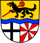
| Blazon : “Shield divided by a blue wavy bar, above a black, red-armored, striding wolf in gold, carrying a red bishop's staff placed at an angle to the left; split at the bottom, a black, continuous cross in silver at the front; reared twelve times by silver and red. " | |
| Justification for the coat of arms: The upper half symbolizes the attributes of St. Remaklus . The dividing wave bar symbolizes the Vinxtbach , the old territorial and language border between Lower and Upper Germany. The lower part indicates the "old" rule: the black cross on a silver background symbolizes the rule of the Electorate of Cologne , the red and silver twelve-fold cross indicates the barons Walpot von Bassenheim . |
Culture and sights
theatre
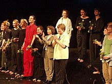
With the TheaterTotal , the nationally important theater project from Bochum makes a guest appearance in the Vinxtbachhalle every year. TheaterTotal is an off-theater project by young actors that does not have its own venue and no permanent ensemble.
Events
- Spectaculum historiae, village festival with references to the historical stations of the place
- St. Remaklus fair, held on the first weekend of September each year by the Catholic bachelor association Waldorf 1738 e. V.
Worth seeing
- St. Remaklus, church building from 1869
- Orchard nature trail
- Local museum
See also: List of cultural monuments in Waldorf
Web links
- Website of the local community Waldorf
- Waldorf in the Vinxtbach valley
- Historical information about Waldorf at regionalgeschichte.net
- Literature about Waldorf in the Rhineland-Palatinate State Bibliography
Individual evidence
- ↑ a b State Statistical Office of Rhineland-Palatinate - population status 2019, districts, municipalities, association communities ( help on this ).
- ↑ State Statistical Office Rhineland-Palatinate (ed.): Official directory of the municipalities and parts of the municipality. Status: January 2019 [ Version 2020 is available. ] . S. 9 (PDF; 3 MB).
- ↑ a b Wilfried Dünchel: Waldorf is almost 1350 years old , in 1995's Heimatjahrbuch, Kreis Ahrweiler, p. 63 ( online )
- ↑ Wilfried Dünchel: Waldorf sank into rubble and ashes in 1824 , in: Heimatjahrbuch 2000 Kreis Ahrweiler, p. 108 ( online )
- ↑ Carl Bertram Hommen: The Waldorfer Familienbuch from 1687 reports ... , in: Heimatjahrbuch 1974 Kreis Ahrweiler, p. 94 ( online )
- ^ Wilhelm Fabricius : Explanations of the historical atlas of the Rhine province, Volume 2: The map of 1789. Bonn 1898, pp. 55, 87.
- ↑ Information from the municipality
- ↑ State Statistical Office Rhineland-Palatinate - regional data
- ^ The Regional Returning Officer Rhineland-Palatinate: Local elections 2019, city and municipal council elections
- ↑ Hans Dieter Felten nominated as a candidate for the mayor. In: Blick Aktuell. Krupp Verlags GmbH, Sinzig, April 1, 2014, accessed on July 21, 2020 .
- ^ The Regional Returning Officer for Rhineland-Palatinate: direct elections 2019. see Bad Breisig, Verbandsgemeinde, last line of results. Retrieved July 21, 2020 .
- ↑ Information from the Koblenz State Main Archives from December 16, 1987
- ^ Project website


