Brenk
| coat of arms | Germany map | |
|---|---|---|

|
Coordinates: 50 ° 26 ' N , 7 ° 10' E |
|
| Basic data | ||
| State : | Rhineland-Palatinate | |
| County : | Ahrweiler | |
| Association municipality : | Brohl valley | |
| Height : | 350 m above sea level NHN | |
| Area : | 3.08 km 2 | |
| Residents: | 190 (Dec. 31, 2019) | |
| Population density : | 62 inhabitants per km 2 | |
| Postal code : | 56651 | |
| Area code : | 02655 | |
| License plate : | AW | |
| Community key : | 07 1 31 201 | |
| LOCODE : | DE NBK | |
| Community structure: | 2 districts | |
| Association administration address: | Kapellenstrasse 12 56651 Niederzissen |
|
| Website : | ||
| Local Mayor : | Christoph Stenz | |
| Location of the local community of Brenk in the Ahrweiler district | ||
Brenk is a municipality in the Ahrweiler district in Rhineland-Palatinate . It belongs to the Brohltal community , which has its administrative headquarters in Niederzissen .
geography
Brenk is four kilometers southwest of Niederzissen in the valley and on the upper reaches of the Brenkbach . The Schellkopf rises to the west ( 495 m above sea level ). The municipality is one of the natural area for Olbrücker Eifel edge and includes the south much of the wildlife sanctuaries Schorberg and Scheldkoepfchen and teaching head . It reaches its lowest point at the Gleeser Bach on the northern border, the highest at the summit of 549 m above sea level. NHN high Schorberg on the western border. The district of Fußhölle, located at the southern foot of the Schellkopf, belongs to Brenk. The municipality is located in the conservation area "Rhein-Ahr-Eifel".
history
Brenk and Fußhölle belonged to the rulership of Olbrück until the end of the 18th century .
Statistics on population development
The development of the population of the municipality of Brenk, the values from 1871 to 1987 are based on censuses:
|
|
politics
Municipal council
The local council in Brenk consists of six council members, who were elected by a majority vote in the local elections on May 26, 2019 , and the honorary local mayor as chairman.
mayor
Christoph Stenz became the local mayor of Brenk on July 6, 2009. In the direct election on May 26, 2019, he was confirmed in his office for a further five years with a share of 70.54% of the votes.
Stenz's predecessor as mayor until 2009 was Herbert Pütz.
coat of arms
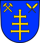
| Justification of the coat of arms: The golden, cross-shaped rod indicates the patron saint of Brenk, the holy New Year's Eve. The crossed golden ears of wheat and the crossed hammers symbolize the phonolite mining in the local community. |
Rail transport
Above the village on the slope runs the route of the meter-gauge ( narrow-gauge railway ) Brohltalbahn , which has a train station (demand stop) in Brenk . Up to the phonolite quarry at Brenk station, the Brohl Valley Railway is also used for freight transport.
Attractions
The chapel in Brenk is dedicated to Holy New Year's Eve and was built in 1867 in neo-Gothic style.
Web links
- Local community Brenk on the website of the Verbandsgemeinde Brohltal
- Literature about Brenk in the Rhineland-Palatinate State Bibliography
Individual evidence
- ↑ State Statistical Office of Rhineland-Palatinate - population status 2019, districts, communities, association communities ( help on this ).
- ↑ State Statistical Office Rhineland-Palatinate (ed.): Official directory of the municipalities and parts of the municipality. Status: January 2019 [ Version 2020 is available. ] . S. 9 (PDF; 3 MB).
- ↑ State Statistical Office Rhineland-Palatinate: Regional data.
- ^ The Regional Returning Officer Rhineland-Palatinate: Local elections 2019, city and municipal council elections.
- ↑ a b 1st meeting of the Brenk municipal council. In: Council and Citizen Information System. Verbandsgemeindeverwaltung Brohltal, July 6, 2009, accessed on August 3, 2020 .
- ^ The Regional Returning Officer of Rhineland-Palatinate: direct elections 2019. see Brohltal, Verbandsgemeinde, eighth line of results. Retrieved August 3, 2020 .


