Hohenleimbach
| coat of arms | Germany map | |
|---|---|---|

|
Coordinates: 50 ° 25 ' N , 7 ° 4' E |
|
| Basic data | ||
| State : | Rhineland-Palatinate | |
| County : | Ahrweiler | |
| Association municipality : | Brohl valley | |
| Height : | 512 m above sea level NHN | |
| Area : | 10.17 km 2 | |
| Residents: | 360 (Dec. 31, 2019) | |
| Population density : | 35 inhabitants per km 2 | |
| Postal code : | 56746 | |
| Area code : | 02655 | |
| License plate : | AW | |
| Community key : | 07 1 31 206 | |
| Association administration address: | Kapellenstrasse 12 56651 Niederzissen |
|
| Website : | ||
| Local Mayor : | Thorsten Kurt Kabuth | |
| Location of the local community Hohenleimbach in the Ahrweiler district | ||
Hohenleimbach is a municipality in the Ahrweiler district in Rhineland-Palatinate . It belongs to the Brohltal community , which has its administrative headquarters in Niederzissen .
geography
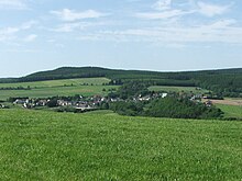
Hohenleimbach is the highest local community of the Verbandsgemeinde Brohltal and is located in its west. The Hohe Acht, the highest point in the Eifel , is about five kilometers southwest of Hohenleimbach.
The Lederbach district, located about one and a half kilometers northeast of the federal highway 412, and the Alexanderhof belong to Hohenleimbach .
history
First mentioned in 1425 as a fiefdom of Peter von Thys in Leimbach , the place was called that until the 20th century and was part of the Kempenich rule , the Kempenicher Ländchen. Since the 18th century, the nickname Wüst-Leimbach or Wüstleimbach (local dialect: Wüstlämisch ), which was used as a mock name, appeared, since many farmsteads were devastated due to the barren fields and the bitter poverty, the residents of which then mostly emigrated to America . In the 18th century, the number of inhabitants fell well below a hundred. Hohenleimbach is listed as Wüxt-Leimbach on the Tranchot - Müffling map from 1809 .
The local council has long sought to give the village a different name. Since March 3, 1916, the town was allowed to rename its name to " Hohenleimbach " according to an imperial decree, following a unanimous municipal council resolution of January 31, 1914 , with the result that the name Wüstleimbach slowly disappeared. Centuries ago the hamlet of Rembach , which was first mentioned in 1337 and in 1404 with four farms, fell into desolation in the 17th century due to poverty and the relocation of its inhabitants , a little below today's town at the confluence of the Lederbach and the Nette .
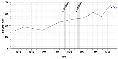
- Population development
The development of the population of Hohenleimbach, the values from 1871 to 1987 are based on censuses:
|
|
politics
Municipal council
The council in Hohenleimbach consists of six council members, who in the local elections on May 26, 2019 in a majority vote were elected, and the honorary mayor as chairman. Until 2014, the council had eight councilors.
mayor
Thorsten Kurt Kabuth became mayor of Hohenleimbach on April 5, 2013. In the direct election on May 26, 2019, he was confirmed in office for another five years with a share of the vote of 83.89%.
Kabuth's predecessor as local mayor was Clemens Seifert.
coat of arms
| Blazon : "In red, inside a golden deciduous tree (linden) over a symmetrical silver-bordered red bar cross, a left silver flank , inside a blue double wave thread." | |
| Justification for the coat of arms: The golden deciduous tree symbolizes the village linden tree in the center of the village. For belonging to Kurtrier (until 1794) the silver-rimmed red bar cross and the shield colors red and silver, the blue wavy threads for the confluence of Lederbach and Leimbach. |
Attractions
In the local community there is a village chapel built in 1963, inside of which there is a tall, seated roof turret and a colored columned altar from the 18th century. The community hall has already been expanded and renovated and is available for club life. One of the most important landmarks in the area is the "Kaiserlinde", a large tree on the village square that was planted in memory of the Battle of the Nations in Leipzig and is one of the symbols in the municipal coat of arms. The other trees in Hohenleimbach are also well cared for and well preserved.
In a broader sense, one of the sights is the Kohlestraße , a trade route that is now a hiking trail. You through the westernmost of Hohenleimbach Langhard, a 1227 First mentioned large contiguous forest area that is particularly large during the 18th century Köhler activity was recorded and not completely disappeared at that time due to colonization and conversion to agricultural land. The Kohlestraße was a charcoal transport route for horse-drawn vehicles from the coal piles (from Vinxtbach) through the Eifel to the ironworks in Saarland , partly on an old Roman road in the Middle Ages and in the 16th and 17th centuries. Century expanded.
See also the list of cultural monuments in Hohenleimbach
economy
The local community is predominantly agricultural and forestry . Many of the residents are employed in the nearby town of Adenau and in commercial enterprises in Kempenich .
literature
- Manfred Becker: Local customs in the Kempenicher Ländchen. In: Homeland yearbook of the Ahrweiler district 1987 , Bad Neuenahr-Ahrweiler 1986
- Bernhard Koll: noble houses in the former Kempenich rule. In: Homeland yearbook of the Ahrweiler district 1985 , Bad Neuenahr-Ahrweiler 1984
- Bernhard Koll: The lords of the Kempenich rule in the 15th and 16th centuries. In: Homeland yearbook of the Ahrweiler district 1987 , Bad Neuenahr-Ahrweiler 1986
- Bernhard Koll, Oliver Schüller u. a .: Between Hoher Acht and Laacher See - From the history of the Kempenicher Ländchen. Heimatfreunde Kempenich, Kempenich 1993; ed. for the 900th anniversary of Kempenich
- Between Hoher Acht and Laacher See - From the history of the Kempenich region. Heimatfreunde Kempenich e. V., Kempenich 1993.
Web links
- Website of the Hohenleimbach community
- Hohenleimbach on the website of the Verbandsgemeinde Brohtal
- Literature about Hohenleimbach in the Rhineland-Palatinate state bibliography
Individual evidence
- ↑ State Statistical Office of Rhineland-Palatinate - population status 2019, districts, communities, association communities ( help on this ).
- ↑ State Statistical Office Rhineland-Palatinate (ed.): Official directory of the municipalities and parts of the municipality. Status: January 2019 [ Version 2020 is available. ] . S. 10 (PDF; 3 MB).
- ↑ State Statistical Office Rhineland-Palatinate: Regional data.
- ^ The Regional Returning Officer Rhineland-Palatinate: Local elections 2019, city and municipal council elections
- ↑ a b 24th meeting of the Hohenleimbach municipal council. In: Council and Citizen Information System. Verbandsgemeindeverwaltung Brohltal, April 5, 2013, accessed on August 3, 2020 .
- ^ The State Returning Officer of Rhineland-Palatinate: direct elections 2019. see Brohltal, Verbandsgemeinde, twelfth line of results. Retrieved August 3, 2020 .


